NI 43-101 TECHNICAL REPORT
Feasibility Study
for the
PAN GOLD PROJECT
White Pine County, Nevada
PREPARED FOR MIDWAY GOLD CORP.

Effective date: November 15, 2011
Signature date: December 19, 2011
Prepared by
William J. Crowl, R.G. QP MMSA
Donald E. Hulse, P.E.
Terre A. Lane, QP MMSA
Donald J. Baker, PhD QP MMSA
Jennifer J. Brown, P.G. Registered Member SME

| Midway Gold Corp. | Date and Signature Pages |
| Pan Gold Project Feasibility Study | NI 43-101 Technical Report |
WILLIAM J. CROWL, R.G.
Vice President, Mining
Gustavson Associates, LLC
274 Union Boulevard, Suite 450
Lakewood, Colorado 80228
Telephone: 720-407-4062 Facsimile: 720-407-4067
Email: wcrowl@gustavson.com
CERTIFICATE of AUTHOR
I, William J. Crowl do hereby certify that:
|
1.
|
I am currently employed as Vice President, Mining by Gustavson Associates, LLC at:
|
274 Union Boulevard
Suite 450
Lakewood, Colorado 80228
|
2.
|
I am a graduate of the University of Southern California with a Bachelor of Arts in Earth Science (1968), and an MSc. in Economic Geology from the University of Arizona in 1979, and have practiced my profession continuously since 1973.
|
|
3.
|
I am a member in good standing of the Mining and Metallurgical Society of America, member # 01412QP
|
|
4.
|
I have worked as a geologist for a total of 38 years since my graduation from university; as a graduate student, as an employee of a major mining company, a major engineering company, and as a consulting geologist.
|
|
5.
|
I have read the definition of “qualified person” set out in NI 43-101 (“NI 43-101”) and certify that by reason of my education, affiliation with a professional association (as defined in NI 43-101) and past relevant work experience, I fulfill the requirements to be a “qualified person” for the purposes of NI 43-101.
|
|
6.
|
I am responsible for the preparation of the report titled “NI 43-101 Technical Report Feasibility Study for the Pan Gold Project, White Pine County, Nevada,” effective date, November 15, 2011 (the “Technical Report”), with specific responsibility for oversight of the entire document.
|
|
7.
|
I am not aware of any material fact or material change with respect to the subject matter of the Technical Report that is not reflected in the Technical Report, the omission to disclose which makes the Technical Report misleading.
|
| December 19, 2011 | i |  |
| Midway Gold Corp. | Date and Signature Pages |
| Pan Gold Project Feasibility Study | NI 43-101 Technical Report |
|
8.
|
I do not hold, nor do I expect to receive, any securities or any other interest in any corporate entity, private or public, with interests in the properties that are the subject of this report or in the properties themselves, nor do I have any business relationship with any such entity apart from a professional consulting relationship with the issuer, nor to the best of my knowledge do I have any interest in any securities of any corporate entity with property within a two (2) kilometer distance of any of the subject properties.
|
|
9.
|
I have read NI 43-101 and Form 43-101, and the Technical Report has been prepared in compliance with that instrument and form.
|
|
10.
|
I consent to the filing of the Technical Report with any stock exchanges or other regulatory authority and any publication by them, including electronic publication in the public company files on the websites accessible by the public, of the Technical Report.
|
Dated this 19th day of December, 2011.
/s/ William J. Crowl (Signature)
Signature of Qualified Person
“William J. Crowl”
Print name of Qualified Person
| December 19, 2011 | ii | |
| Midway Gold Corp. | Date and Signature Pages |
| Pan Gold Project Feasibility Study | NI 43-101 Technical Report |
DONALD E. HULSE, P.E.
Principal Mining Engineer
Gustavson Associates, LLC
274 Union Boulevard, Suite 450
Lakewood, Colorado 80228
Telephone: 720-407-4062 Facsimile: 720-407-4067
Email: dhulse@gustavson.com
CERTIFICATE of AUTHOR
I, Donald E. Hulse do hereby certify that:
|
1.
|
I am currently employed as Principal Mining Engineer by Gustavson Associates, LLC at:
|
274 Union Boulevard
Suite 450
Lakewood, Colorado 80228
|
2.
|
I am a graduate of the Colorado School of Mines with a Bachelor of Science in Mining Engineering (1982), and have practiced my profession continuously since 1983.
|
|
3.
|
I am a registered Professional Engineer in the State of Colorado (35269).
|
|
4.
|
I have worked as a mining engineer for a total of 25 years since my graduation from university; as an employee of a major mining company, a major engineering company, and as a consulting engineer.
|
|
5.
|
I have read the definition of “qualified person” set out in NI 43-101 (“NI 43-101”) and certify that by reason of my education, affiliation with a professional association (as defined in NI 43-101) and past relevant work experience, I fulfill the requirements to be a “qualified person” for the purposes of NI 43-101.
|
|
6.
|
I am responsible for the preparation of the technical report titled “NI 43-101 Technical Report Feasibility Study for the Pan Gold Project, White Pine County, Nevada,” effective date, November 15, 2011 (the “Technical Report”), with specific responsibility for Sections 14, 15, and 19 through 27.
|
|
7.
|
I am not aware of any material fact or material change with respect to the subject matter of the Technical Report that is not reflected in the Technical Report, the omission to disclose which makes the Technical Report misleading.
|
| December 19, 2011 | iii | |
| Midway Gold Corp. | Date and Signature Pages |
| Pan Gold Project Feasibility Study | NI 43-101 Technical Report |
|
8.
|
I do not hold, nor do I expect to receive, any securities or any other interest in any corporate entity, private or public, with interests in the properties that are the subject of this report or in the properties themselves, nor do I have any business relationship with any such entity apart from a professional consulting relationship with the issuer, nor to the best of my knowledge do I have any interest in any securities of any corporate entity with property within a two (2) kilometer distance of any of the subject properties.
|
|
9.
|
I have read NI 43-101 and Form 43-101, and the Technical Report has been prepared in compliance with that instrument and form.
|
|
10.
|
I consent to the filing of the Technical Report with any stock exchanges or other regulatory authority and any publication by them, including electronic publication in the public company files on the websites accessible by the public, of the Technical Report.
|
Dated this 19th day of December, 2011.
/s/Donald E. Hulse (Signature)
Signature of Qualified Person
“Donald E. Hulse”
Print name of Qualified Person
| December 19, 2011 | iv | |
| Midway Gold Corp. | Date and Signature Pages |
| Pan Gold Project Feasibility Study | NI 43-101 Technical Report |
TERRE A. LANE
Associate Principal Mining Engineer
Gustavson Associates, LLC
274 Union Boulevard, Suite 450
Lakewood, Colorado 80228
Telephone: 720-407-4062 Facsimile: 720-407-4067
Email: tlane@gustavson.com
CERTIFICATE of AUTHOR
I, Terre A. Lane do hereby certify that:
|
1.
|
I am currently employed as Principal Mining Engineer by Gustavson Associates, LLC at:
|
274 Union Boulevard
Suite 450
Lakewood, Colorado 80228
|
2.
|
I am a graduate of the Michigan Technological University of Michigan with a Bachelor of Science degree in Mining Engineering (1982).
|
|
3.
|
I am a member in good standing of the Mining and Metallurgical Society of America, member #10407QP
|
|
4.
|
I have worked as a Mine Engineer for a total of 23 years since my graduation from university; as an employee of several mining companies, an engineering company, a mine development and mine construction company, an exploration company, and as a consulting engineer.
|
|
5.
|
I have read the definition of “qualified person” set out in NI 43-101 (“NI 43-101”) and certify that by reason of my education, affiliation with a professional association (as defined in NI 43-101) and past relevant work experience, I fulfill the requirements to be a “qualified person” for the purposes of NI 43-101.
|
|
6.
|
I am responsible for the preparation of the report titled “NI 43-101 Technical Report Feasibility Study for the Pan Gold Project, White Pine County, Nevada,” effective date, November 15, 2011 (the “Technical Report”), with specific responsibility for Sections 1, 9 through 13, and 16 through 18. I most recently visited the property May 27, 2010.
|
|
7.
|
I have personally completed an independent review and analysis of the data and written information contained in this Technical Report.
|
|
8.
|
I am not aware of any material fact or material change with respect to the subject matter of the Technical Report that is not reflected in the Technical Report, the omission to disclose which makes the Technical Report misleading.
|
| December 19, 2011 | v | |
| Midway Gold Corp. | Date and Signature Pages |
| Pan Gold Project Feasibility Study | NI 43-101 Technical Report |
|
9.
|
I do not hold, nor do I expect to receive, any securities or any other interest in any corporate entity, private or public, with interests in the properties that are the subject of this report or in the properties themselves, nor do I have any business relationship with any such entity apart from a professional consulting relationship with the issuer, nor to the best of my knowledge do I have any interest in any securities of any corporate entity with property within a two (2) kilometer distance of any of the subject properties.
|
|
10.
|
I have read NI 43-101 and Form 43-101, and the Technical Report has been prepared in compliance with that instrument and form.
|
|
11.
|
I consent to the filing of the Technical Report with any stock exchanges or other regulatory authority and any publication by them, including electronic publication in the public company files on the websites accessible by the public, of the Technical Report.
|
Dated this 19th day of December, 2011.
/s/Terre A. Lane (Signature)
Signature of Qualified Person
“Terre A. Lane”
Print name of Qualified Person
| December 19, 2011 | vi | |
| Midway Gold Corp. | Date and Signature Pages |
| Pan Gold Project Feasibility Study | NI 43-101 Technical Report |
DONALD J. BAKER, PhD
Associate Principal Geologist
Gustavson Associates, LLC
274 Union Boulevard, Suite 450
Lakewood, Colorado 80228
Telephone: 720-407-4062 Facsimile: 720-407-4067
Email: dbaker@gustavson.com
CERTIFICATE of AUTHOR
I, Donald J. Baker do hereby certify that:
|
1.
|
I am currently employed as Associate Principal Geologist by Gustavson Associates, LLC at:
|
274 Union Boulevard
Suite 450
Lakewood, Colorado 80228
|
2.
|
I am a graduate of The Ohio State University with an MSc in Geology (1974), a PhD. in Geology from the University of Georgia (1980), and an M.B.A. from the University of Colorado at Denver (1991) and have practiced my profession continuously since 1978.
|
|
3.
|
I am a member in good standing of the Mining and Metallurgical Society of America, member #01088QP.
|
|
4.
|
I have worked as a geologist for a total of 40 years since my graduation from university; as a graduate student, as an employee of a major mining company, a major engineering company, and as a consulting geologist.
|
|
5.
|
I have read the definition of “qualified person” set out in NI 43-101 (“NI 43-101”) and certify that by reason of my education, affiliation with a professional association (as defined in NI 43-101) and past relevant work experience, I fulfill the requirements to be a “qualified person” for the purposes of NI 43-101.
|
|
6.
|
I am responsible for the preparation of the report titled “NI 43-101 Technical Report Feasibility Study for the Pan Gold Project, White Pine County, Nevada,” effective date, November 15, 2011 (the “Technical Report”), with specific responsibility for Sections 7 and 8.
|
|
7.
|
I have personally completed an independent review and analysis of the data and written information contained in this Technical Report.
|
|
8.
|
I am not aware of any material fact or material change with respect to the subject matter of the Technical Report that is not reflected in the Technical Report, the omission to disclose which makes the Technical Report misleading.
|
| December 19, 2011 | vii | |
| Midway Gold Corp. | Date and Signature Pages |
| Pan Gold Project Feasibility Study | NI 43-101 Technical Report |
|
9.
|
I do not hold, nor do I expect to receive, any securities or any other interest in any corporate entity, private or public, with interests in the properties that are the subject of this report or in the properties themselves, nor do I have any business relationship with any such entity apart from a professional consulting relationship with the issuer, nor to the best of my knowledge do I have any interest in any securities of any corporate entity with property within a two (2) kilometer distance of any of the subject properties.
|
|
10.
|
I have read NI 43-101 and Form 43-101, and the Technical Report has been prepared in compliance with that instrument and form.
|
|
11.
|
I consent to the filing of the Technical Report with any stock exchanges or other regulatory authority and any publication by them, including electronic publication in the public company files on the websites accessible by the public, of the Technical Report.
|
Dated this 19th day of December, 2011.
/s/Donald J. Baker (Signature)
Signature of Qualified Person
“Donald J. Baker”
Print name of Qualified Person
| December 19, 2011 | viii | |
| Midway Gold Corp. | Date and Signature Pages |
| Pan Gold Project Feasibility Study | NI 43-101 Technical Report |
JENNIFER J. BROWN, P.G.
Principal Geologist
Lowham Walsh LLC1
205 South Third Street
Lander, Wyoming USA 82520
Telephone: 307-335-8466 Facsimile: 307-335-7343
Email: jjbrown@lowhamwalsh.com
CERTIFICATE of AUTHOR
I, Jennifer J. Brown, do hereby certify that:
|
1.
|
I am currently employed as a Principal Geologist by Lowham Walsh LLC at:
|
205 South Third Street
Lander, Wyoming USA 82520
|
2.
|
I am a graduate of the University of Montana with a Bachelor of Arts in Geology (1996), and I have practiced my profession continuously since 1997.
|
|
3.
|
I am a licensed Professional Geologist in the States of Wyoming (PG-3719) and Idaho (PGL-1414), and am a Registered Member in good standing of the Society of Mining, Metallurgy and Exploration (#4168244RM) with recognized special expertise in geology and mining. I am also a member of the American Institute of Professional Geologists (MEM-0174)
|
|
4.
|
I have worked as a geologist for a total of 14 years since graduation from university - as an employee of four separate engineering and geological consulting firms and the U.S.D.A. Forest Service.
|
|
5.
|
I have read the definition of “qualified person” set out in National Instrument 43-101 (“NI 43-101”) and certify that by reason of my education, affiliation with a professional association (as defined in NI 43-101) and past relevant work experience, I fulfill the requirements to be a “qualified person” for the purposes of NI 43-101.
|
|
6.
|
I am responsible for the preparation of the technical report titled “NI 43-101 Technical Report Feasibility Study for the Pan Gold Project, White Pine County, Nevada,” effective date, November 15, 2011 (the “Technical Report”), with specific responsibility for Sections 2 through 6, and overall organization and preparation of the Technical Report.
|
|
1 Lowham Walsh LLC is part of a group of companies, including Gustavson Associates, that are controlled by Ecology and Environment, Inc.
|
| December 19, 2011 | ix | |
| Midway Gold Corp. | Date and Signature Pages |
| Pan Gold Project Feasibility Study | NI 43-101 Technical Report |
|
7.
|
I have not had prior involvement with the properties that are the subject of the Technical Report.
|
|
8.
|
I am independent of the issuer applying all of the tests in Section 1.5 of National Instrument 43-101.
|
|
9.
|
As of the date of this certificate, to the best of my knowledge, information and belief, the Technical Report contains all scientific and technical information that is required to be disclosed and I am not aware of any material fact or material change with respect to the subject matter of the Technical Report that is not reflected in the Technical Report, the omission to disclose which makes the Technical Report misleading.
|
|
10.
|
I have read National Instrument 43-101 and Form 43-101, and the Technical Report has been prepared in compliance with that instrument and form.
|
Dated this 19th day of December, 2011.
/s/ Jennifer J. Brown (Signature)
Signature of Qualified Person
“Jennifer J. Brown”
Print name of Qualified Person
| December 19, 2011 | x | |
| Midway Gold Corp. | Table of Contents |
| Pan Gold Project Feasibility Study | NI 43-101 Technical Report |

| December 19, 2011 | xi | |
| Midway Gold Corp. | Table of Contents |
| Pan Gold Project Feasibility Study | NI 43-101 Technical Report |

| December 19, 2011 | xii | |
| Midway Gold Corp. | Table of Contents |
| Pan Gold Project Feasibility Study | NI 43-101 Technical Report |

| December 19, 2011 | xiii | |
| Midway Gold Corp. | Table of Contents |
| Pan Gold Project Feasibility Study | NI 43-101 Technical Report |

| December 19, 2011 | xiv | |
| Midway Gold Corp. | Table of Contents |
| Pan Gold Project Feasibility Study | NI 43-101 Technical Report |
| December 19, 2011 | xv | |
| Midway Gold Corp. | Table of Contents |
| Pan Gold Project Feasibility Study | NI 43-101 Technical Report |
LIST OF FIGURES

| December 19, 2011 | xvi | |
| Midway Gold Corp. | Table of Contents |
| Pan Gold Project Feasibility Study | NI 43-101 Technical Report |
LIST OF TABLES
| December 19, 2011 | xvii | |
| Midway Gold Corp. | Table of Contents |
| Pan Gold Project Feasibility Study | NI 43-101 Technical Report |

| December 19, 2011 | xviii | |
| Midway Gold Corp. | Table of Contents |
| Pan Gold Project Feasibility Study | NI 43-101 Technical Report |

| December 19, 2011 | xix | |
| Midway Gold Corp. | Summary |
| Pan Gold Project Feasibility Study | NI 43-101 Technical Report |
|
1
|
SUMMARY
|
|
1.1
|
Introduction
|
Gustavson Associates, LLC (Gustavson) was commissioned by Midway Gold Corp. to complete a Feasibility Study for the Pan Gold Project in White Pine County, Nevada, based on the Updated Mineral Resource Estimate dated September 1, 2011. The Feasibility Study is intended to provide a comprehensive technical and economic analysis of the selected development option for the mineral project. This study includes detailed assessments of realistically assumed mining, processing, metallurgical, economic, legal, environmental, social, and other relevant considerations which have successfully demonstrated the economic viability of the project. The purpose of this report is to document the results of the Feasibility Study in compliance with Canadian National Instrument 43-101 Standards of Disclosure for Mineral Projects.
The Pan gold deposit is a sediment-hosted, bulk tonnage Carlin-type gold deposit along the prolific Battle Mountain-Eureka gold trend in east-central Nevada. Midway Gold US Inc. (hereafter referred to as MIDWAY) has drilled, sampled, and mapped the Pan deposit since acquiring the project in 2007. MIDWAY completed 61,875 ft of drilling in 162 holes in 2007 and 2008, and released an updated mineral resource estimate in December 2009. Gustavson performed an independent audit of the 2009 mineral resource estimate as part of a Preliminary Economic Assessment in 2010, and MIDWAY conducted a 14-hole (5774 ft) diamond core drilling program to obtain additional metallurgical and geotechnical data during the latter half of that same year. Gustavson completed a mineral reserve and mine plan as part of the March 2011 Preliminary Feasibility Study, which included an updated geologic model and mineral resource based on data obtained through February 28, 2011. MIDWAY has since completed an additional 33 holes totaling 27,795 ft.
|
1.2
|
Property Description and Ownership
|
The Pan Project is located in White Pine County, Nevada, approximately 22 miles southeast of Eureka and 50 miles west of Ely. The project area consists of 10,373 acres on 550 contiguous, unpatented federal mining claims controlled by MIDWAY. The property is located in the rolling hills of the Pancake Range in the Basin and Range physiographic province. Terrain is gentle to moderate throughout most of the project area, with no major stream drainages. Elevation of the property ranges from 6,400 to 7,500 ft above mean sea level.
At present, no infrastructure or power is in place at the Pan site. A relatively low voltage distribution line crosses the valley floor near a local ranch approximately 5 miles away. A higher voltage transmission line, 69 kV, with capacity suitable for mining and processing operations, is located approximately 14 miles from the project site and six miles north of US 50. Water to support exploration drilling is available from ranch wells approximately 3 miles to the west of the property. Logistical support is available in Eureka, Ely, and Elko, all of which currently
| December 19, 2011 | 1 | |
| Midway Gold Corp. | Summary |
| Pan Gold Project Feasibility Study | NI 43-101 Technical Report |
support large open pit mining operations. Mining personnel and resources for operations at Pan are expected to be available from Eureka, White Pine, and Elko Counties.
|
1.3
|
Geology and Mineralization
|
The geology of the Pan property is dominated by Devonian to Permian carbonate and clastic sedimentary rocks cut by the Pan fault, a steeply west dipping fault that trends north-south. The Pan fault juxtaposes gently west dipping sedimentary units on the west side of the fault with steeply northeast dipping sedimentary units on the east side. Post-mineral Tertiary volcanic rocks nonconformably overlie the faulted Devonian-Permian sedimentary units.
Gold mineralization at Pan occurs in a Carlin-style, epithermal, disseminated, sediment-hosted system. The distribution of the mineralization is controlled by structure, particularly with regard to the development of breccias, and by sedimentary bedding and alteration along unit contacts. Gold deposits within the project area generally occur as elongate bodies associated with structures and dissolution/hydrothermal breccia bodies hosted by the Pilot Shale and, to a lesser extent, the Devils Gate Limestone. Gold deposits also occur in a more tabular fashion within altered and mineralized sedimentary horizons.
|
1.4
|
Concept and Status of Exploration
|
MIDWAY’s exploration program includes core and reverse circulation drilling, geologic mapping, geochemical sampling, and geophysical surveys at the Pan property. This comprehensive program has helped to define the geologic occurrence of gold mineralization and identify additional exploration targets on the Pan property. The level of exploration in individual target areas varies from rock and soil sampling with anomalous results to drill holes which reveal anomalous to ore-grade gold values, as determined during the February 2011 Preliminary Feasibility Study. Geochemical and geophysical targets merit additional work, primarily drilling, to test anomalous rock and soil geochemical results. Additional drilling is needed in portions of the deposit to expand and better understand existing drill intercepts.
|
1.5
|
Mineral Resource Estimate
|
Gustavson completed an updated mineral resource estimate for the Pan Project in November 2011. As part of that study, Gustavson created a model to estimate the mineral resources at Pan based on data provided by MIDWAY as of September 1, 2011. No new drilling occurred at North Pan and the February 2011 resource model was not modified during the current study. Gold mineralization in Central and South Pan was re-evaluated during the course of this resource update. Drill hole data including collar coordinates, MIDWAY surveys, sample assay intervals, and geologic logs were provided in a secure Microsoft Access database. Surficial geology maps and cross-sections detailing alteration and lithology were also provided in electronic format. The database has been updated to include the additional 33 reverse circulation drill holes completed by MIDWAY in 2011.
| December 19, 2011 | 2 | |
| Midway Gold Corp. | Summary |
| Pan Gold Project Feasibility Study | NI 43-101 Technical Report |
Gustavson modeled and estimated the mineral resource by constructing geologic, alteration, and mineral domains from the MIDWAY cross sections, and by geostatistically analyzing the drill data to define the parameters required to estimate gold grades in the 3-Dimensional (3D) block model. Leapfrog 3D® geological modeling software was used to create 3D stratigraphic, alteration, and mineral domain solids. MicroModel® software was used to estimate gold grades.
MIDWAY defined the structure, stratigraphy, and alteration of the North, Central, and South Pan zones on 1 inch = 50 ft cross-sections spaced 200 feet apart and oriented east to west. Gustavson combined the MIDWAY subsurface interpretations with surface geology to create 3D stratigraphic and alteration models.
A block model was created for the Pan Deposit using blocks that are 20 feet wide, 20 feet long, and 20 feet high. Each of the blocks was assigned attributes of gold grade, mineral resource classification, rock density, tonnage factor, lithology, alteration, and a grade classification. The blocks were then assigned to a domain as appropriate to assist in estimation.
|
1.5.1
|
North Pan
|
All of the domains were estimated in 3 passes and each block was assigned a classification of measured, indicated, or inferred. The resource classification of each block was based on a factor of the average sample distance in an anisotropic direction as established by the second structure range from the variogram model for the domain being estimated. The measured class utilized a ½ ellipsoid variogram search distance. Indicated was set at a full variogram search distance and inferred was set at 2 times the variogram distance. As an additional requirement, Gustavson limited the measured and indicated estimation data to include only the fire assay intervals. Inferred resource was estimated using all available assay data. Ordinary Kriging was used to estimate grade for all domains.
|
1.5.2
|
Central and South Pan
|
All of the domains were estimated by using large search ellipses oriented in the direction of maximum continuity to provide an estimation of the gold grade within every block inside of the grade shells. The resource classification of each block was based on a factor of the closest sample distance in an anisotropic direction as established by the second structure range from the variogram model for the domain being estimated. The measured class utilized a ½ ellipsoid variogram search distance. Indicated resource was set at a full variogram search distance and inferred resource was set at 2 times the variogram distance. Each domain was estimated using a minimum of 5 composites with no more than 4 composites from a single drill hole. A maximum of 12 composites was allowed to better represent the local variability. Ordinary Kriging was used to estimate grade for all domains.
| December 19, 2011 | 3 | |
| Midway Gold Corp. | Summary |
| Pan Gold Project Feasibility Study | NI 43-101 Technical Report |
The mineral resource estimate is summarized in Tables 1-1 through 1-4. This mineral resource estimate includes all drill data obtained as of September 1, 2011, and has been independently verified by Gustavson.
Table 1-1 North Pan Mineral Resource
|
North Pan Measured Resource
|
|||
|
Opt
|
Tons
|
Au Opt
|
oz
|
|
0.008
|
13,994,415
|
0.0168
|
234,844
|
|
0.006
|
15,592,007
|
0.0158
|
245,850
|
|
0.004
|
18,597,319
|
0.0140
|
260,404
|
|
North Pan Indicated Resource
|
|||
|
0.008
|
10,565,126
|
0.0146
|
154,540
|
|
0.006
|
12,702,959
|
0.0133
|
169,135
|
|
0.004
|
17,006,845
|
0.0112
|
189,823
|
|
North Pan Measured plus Indicated Resource
|
|||
|
0.008
|
24,559,541
|
0.0159
|
389,384
|
|
0.006
|
28,294,966
|
0.0147
|
414,985
|
|
0.004
|
35,604,164
|
0.0126
|
450,228
|
|
North Pan Inferred Resource
|
|||
|
0.008
|
122,858
|
0.0112
|
1,376
|
|
0.006
|
233,476
|
0.0091
|
2,129
|
|
0.004
|
511,402
|
0.0067
|
3,427
|
Table 1-2 Central Pan Mineral Resource
|
Central Pan Measured Resource
|
|||
|
Opt
|
Tons
|
Au Opt
|
oz
|
|
0.008
|
2,329,227
|
0.0146
|
33,991
|
|
0.006
|
2,837,448
|
0.0132
|
37,482
|
|
0.004
|
3,802,537
|
0.0111
|
42,192
|
|
Central Pan Indicated Resource
|
|||
|
0.008
|
1,895,266
|
0.0122
|
23,216
|
|
0.006
|
2,524,520
|
0.0109
|
27,623
|
|
0.004
|
4,053,056
|
0.0086
|
34,885
|
|
Central Pan Measured plus Indicated Resource
|
|||
|
0.008
|
4,224,493
|
0.0135
|
57,207
|
|
0.006
|
5,361,968
|
0.0121
|
65,105
|
|
0.004
|
7,855,593
|
0.0098
|
77,077
|
|
Central Pan Inferred Resource
|
|||
|
0.008
|
240,912
|
0.0103
|
2,470
|
|
0.006
|
290,465
|
0.0096
|
2,802
|
|
0.004
|
722,079
|
0.0066
|
4,741
|
| December 19, 2011 | 4 | |
| Midway Gold Corp. | Summary |
| Pan Gold Project Feasibility Study | NI 43-101 Technical Report |
Table 1-3 South Pan Mineral Resource
|
South Pan Measured Resource
|
|||
|
Opt
|
Tons
|
Au Opt
|
oz
|
|
0.008
|
13,826,998
|
0.0182
|
251,350
|
|
0.006
|
15,584,480
|
0.0169
|
263,423
|
|
0.004
|
18,297,337
|
0.0151
|
276,641
|
|
South Pan Indicated Resource
|
|||
|
0.008
|
17,440,794
|
0.0158
|
275,596
|
|
0.006
|
20,764,856
|
0.0144
|
298,599
|
|
0.004
|
26,469,130
|
0.0123
|
325,863
|
|
South Pan Measured plus Indicated Resource
|
|||
|
0.008
|
31,267,792
|
0.0169
|
526,946
|
|
0.006
|
36,349,336
|
0.0155
|
562,022
|
|
0.004
|
44,766,467
|
0.0135
|
602,504
|
|
South Pan Inferred Resource
|
|||
|
0.008
|
1,588,716
|
0.0184
|
29,274
|
|
0.006
|
1,933,540
|
0.0164
|
31,651
|
|
0.004
|
3,096,599
|
0.0120
|
37,093
|
Table 1-4 Total Pan Mineral Resource
|
Pan Total Measured Resource
|
|||
|
Opt
|
Tons
|
Au Opt
|
oz
|
|
0.008
|
30,150,640
|
0.0173
|
520,186
|
|
0.006
|
34,013,935
|
0.0161
|
546,756
|
|
0.004
|
40,697,193
|
0.0142
|
579,238
|
|
Pan Total Indicated Resource
|
|||
|
0.008
|
29,901,186
|
0.0152
|
453,351
|
|
0.006
|
35,992,335
|
0.0138
|
495,357
|
|
0.004
|
47,529,031
|
0.0116
|
550,571
|
|
Pan Total Measured plus Indicated Resource
|
|||
|
0.008
|
60,051,826
|
0.0162
|
973,537
|
|
0.006
|
70,006,270
|
0.0149
|
1,042,112
|
|
0.004
|
88,226,224
|
0.0128
|
1,129,809
|
|
Pan Total Inferred Resource
|
|||
|
0.008
|
1,952,486
|
0.0170
|
33,120
|
|
0.006
|
2,457,481
|
0.0149
|
36,581
|
|
0.004
|
4,330,080
|
0.0105
|
45,261
|
| December 19, 2011 | 5 | |
| Midway Gold Corp. | Summary |
| Pan Gold Project Feasibility Study | NI 43-101 Technical Report |
|
1.6
|
Mineral Reserve Estimate
|
The February 2011 Prefeasibility Study demonstrated that the Pan Project is economically viable, and this Feasibility Study has strengthened that conclusion. Based on the results of the Feasibility Study, Measured and Indicated Mineral Reserves within the designed pits are considered Proven and Probable Reserves as defined by the Canadian Institute of Mining, Metallurgy, and Petroleum. The final reserves are reported using a 0.008 Au opt cutoff for the North and Central pits, and a 0.006 Au opt cutoff for the South pit. Cutoffs were chosen to maximize the NPV of the project and do not necessarily represent the minimum economic cutoff. Pit designs are based on geologic criteria provided in the April 2011 Pit Slope Evaluation report produced by Golder Associates. Geologic solids created for each lithological unit were used as a guide during the pit design process. The limestone units were designed with a 50° inter-ramp wall angle assuming pre-split blasting in these units; all other lithological units were designed with a 45° inter-ramp wall angle.
|
1.6.1
|
Whittle Optimization
|
Gustavson generated a series of optimization shells on the South and North resource blocks, ranging from $236/oz to $2360/oz. Forty six shells were generated separately for the North and South resource areas. Heap leach recoveries of 65% and 85%, for North and South Pan, respectively, were used in the optimization runs. The general parameters were based on preliminary estimates of operating cost, and incorporated recommendations from the April 2011 Pit Slope Evaluation report. Mining costs were estimated to be $1.09/ton of material moved for the pit optimization. Crushing, agglomeration, leaching, general and administration, and gold recovery costs were estimated at $3.71/ton of ore. Only Measured and Indicated Resources were considered in the evaluation; Inferred resources were treated as waste.
|
1.6.2
|
Calculation Parameters
|
The series of pit optimizations were graphed and evaluated to compare cash flows, net present values (NPV’s) and internal rates of return (IRR’s). The final South pit and the North pit optimizations are based on shells at a cost less than the three year trailing average price of
| December 19, 2011 | 6 | |
| Midway Gold Corp. | Summary |
| Pan Gold Project Feasibility Study | NI 43-101 Technical Report |
$1200/oz in order to achieve a higher NPV and overall lower cash cost per ounce. The option of mining the entire South Pan pit before the North Pan pit was evaluated during the scheduling process. Although the South Pan pit has a 20% higher recovery factor, mining the South Pan in phases results in a higher IRR by delaying the high strip of the Phase 2 South Pit until the end of the mine life. The option of mining the North pit first was also evaluated, but the higher recovery from the South Pan pit (85%, compared to 65% from North Pan) and shorter estimated leach times render the South pit the more favorable option to mine first.
|
1.6.3
|
Cutoff Grade Equations
|
The mineral reserve estimate for the Pan Project is based on designed open pits with maximized revenues at a gold price of $1180 per ounce. Cutoff grades of 0.006 Au opt (0.21 gpt) in the South pit and 0.008 Au opt (0.27 gpt) in the North & Central pits provide the highest NPV for the project.
|
1.6.4
|
Mineral Reserve Estimate
|
Using the NI 43-101 Updated Mineral Resource Estimate filed in November 2011, Proven and Probable Reserves of 53,254,000 tons at a grade of 0.016 opt are contained in the mineral resource at Pan. A total of 864,000 oz of gold are contained in the Pan Project mineral reserves. Estimated mineral reserves for the Pan Project are presented in Table 1-5.
Table 1-5 Pan Project Mineral Reserves Estimate
|
North and Central Pan
|
Tons
|
Gold
|
|
|
Cutoff Grade:
|
(x 1000)
|
opt
|
ounces (x 1000)
|
|
0.008 opt / 0.274 g/tonnes
|
|||
|
North Pan
|
|||
|
Proven Reserves
|
12,625
|
0.018
|
223.30
|
|
Probable Reserves
|
10,993
|
0.015
|
162.66
|
|
Proven & Probable Reserves
|
23,618
|
0.016
|
385.95
|
|
Inferred within Designed Pit
|
351
|
0.012
|
4.29
|
|
Waste within Designed Pit
|
27,823
|
||
|
Total tons within Designed Pit
|
51,791
|
||
|
Central Pan
|
|||
|
Proven Reserves
|
1,799
|
0.015
|
27.78
|
|
Probable Reserves
|
1,125
|
0.013
|
15.00
|
|
Proven & Probable Reserves
|
2,924
|
0.015
|
42.78
|
|
Inferred within Designed Pit
|
75
|
0.010
|
0.77
|
|
Waste within Designed Pit
|
5,387
|
||
|
Total tons within Designed Pit
|
8,386
|
||
|
Sub Total - North + Central
|
|||
|
Proven Reserves
|
14,423
|
0.017
|
251.08
|
|
Probable Reserves
|
12,119
|
0.015
|
177.66
|
|
Proven & Probable Reserves
|
26,542
|
0.016
|
428.74
|
|
Inferred within Designed Pit
|
426
|
0.012
|
5.06
|
|
Waste within Designed Pit
|
33,210
|
||
|
Total tons within Designed Pit
|
60,177
|
||
| December 19, 2011 | 7 | |
| Midway Gold Corp. | Summary |
| Pan Gold Project Feasibility Study | NI 43-101 Technical Report |
Table 1-5 cont.
|
South Pan - Phases 1 and 2
|
Tons
|
Gold
|
|
|
Cutoff Grade:
|
(x 1000)
|
opt
|
ounces (x 1000)
|
|
0.006 opt / 0.206 g/tonnes
|
|||
|
South Pan - Phase 1
|
|||
|
Proven Reserves
|
11,856
|
0.018
|
215.44
|
|
Probable Reserves
|
7,593
|
0.016
|
119.26
|
|
Proven & Probable Reserves
|
19,449
|
0.017
|
334.70
|
|
Inferred within Designed Pit
|
56
|
0.010
|
0.55
|
|
Waste within Designed Pit
|
31,887
|
||
|
Total tons within Designed Pit
|
51,392
|
||
|
South Pan - Phase 2
|
|||
|
Proven Reserves
|
1,548
|
0.014
|
21.01
|
|
Probable Reserves
|
5,716
|
0.014
|
79.80
|
|
Proven & Probable Reserves
|
7,263
|
0.014
|
100.81
|
|
Inferred within Designed Pit
|
212
|
0.016
|
3.39
|
|
Waste within Designed Pit
|
29,485
|
||
|
Total tons within Designed Pit
|
36,961
|
||
|
Sub Total - Phase 1 + 2
|
|||
|
Proven Reserves
|
13,404
|
0.018
|
236.46
|
|
Probable Reserves
|
13,308
|
0.015
|
199.05
|
|
Proven & Probable Reserves
|
26,713
|
0.016
|
435.51
|
|
Inferred within Designed Pit
|
269
|
0.015
|
3.94
|
|
Waste within Designed Pit
|
61,372
|
||
|
Total tons within Designed Pit
|
88,353
|
||
|
Total Reserves
|
Tons
|
Gold
|
|
|
(x 1000)
|
opt
|
ounces (x 1000)
|
|
|
Proven Reserves
|
27,827
|
0.018
|
487.51
|
|
Probable Reserves
|
25,427
|
0.015
|
376.71
|
|
Proven & Probable Reserves
|
53,254
|
0.016
|
864.22
|
|
Inferred within Designed Pit
|
695
|
0.013
|
9.0
|
|
Waste within Designed Pit
|
94,582
|
||
|
Total tons within Designed Pit
|
148,531
|
||
| December 19, 2011 | 8 | |
| Midway Gold Corp. | Summary |
| Pan Gold Project Feasibility Study | NI 43-101 Technical Report |
|
1.7
|
Conclusions and Recommendations
|
As a result of the work done as part of and resulting from this Feasibility Study, Gustavson concludes:
|
●
|
The Pan deposit now contains over 1.1 million ounces of gold in Measured and Indicated Mineral Resource categories using a 0.004 opt cutoff.
|
|
●
|
There continues to be good potential for the discovery of additional Mineral Resources at Pan.
|
|
●
|
There is a proven and probable Mineral Reserve of 53,254,000 tons, containing 864,000 ounces of gold.
|
|
●
|
The Pan project is an economic mining project generating approximately $122 million net present value, and an internal rate of return of 32.4% at a gold price of $1200.
|
Based on the results of this Feasibility Study, Gustavson recommends:
|
●
|
Continuation of drilling to fill-in areas that are promising development areas, specifically between the North and South pits. MIDWAY is planning on $ 1.5 million in drilling for the next two years.
|
|
●
|
Finalization of engineering for infrastructure, buildings, mining, and site facilities. This is currently estimated at $0.86 million (included in capital costs in the Feasibility Study)
|
|
●
|
Support for the EIS and permitting, estimated to be $ 0.4 million over the next 2 years.
|
|
●
|
Construction of the access road which is estimated at $ 1.7 million.
|
|
●
|
Drilling and testing of a water well, estimated at $0.1 million.
|
|
●
|
Purchase of long-lead equipment estimated at approximately $ 2.0 million.
|
| December 19, 2011 | 9 | |
| Midway Gold Corp. | Introduction |
| Pan Gold Project Feasibility Study | NI 43-101 Technical Report |
|
2
|
INTRODUCTION
|
|
2.1
|
Purpose
|
Gustavson Associates, LLC (Gustavson) was commissioned by Midway Gold Corp. to conduct a Feasibility Study for the Pan Project in White Pine County, Nevada. The purpose of this report is to document the results of the Feasibility Study according to Canadian National Instrument 43-101 Standards of Disclosure for Mineral Projects and guidelines for technical reporting. This study includes detailed assessments of realistically assumed mining, processing, metallurgical, economic, legal, environmental, social, and other relevant considerations needed to demonstrate the economic viability of the project. All data and interpretations are based on information available prior to the effective date of this report, November 15, 2011.
|
2.2
|
Qualified Persons
|
The qualified persons responsible for this report are:
|
●
|
William J. Crowl, R.G., Vice President, Mining Sector, Gustavson Associates
|
|
●
|
Donald E. Hulse, PE, Principal Mining Engineer, Gustavson Associates
|
|
●
|
Terre A. Lane, Member MMSA QP Reserves and Mining, Associate Principal Mining Engineer, Gustavson Associates
|
|
●
|
Donald J. Baker, PhD, QP Geology and Reserves, Member MMSA, Associate Principal Geologist, Gustavson Associates
|
|
●
|
Jennifer J. Brown, P.G., Registered Member SME, Principal Geologist, Lowham Walsh LLC
|
Terre Lane acted as project manager during preparation of this report, and is specifically responsible for Sections 1, 9 through 13, and 16 through 18. Dr. Donald Baker is responsible for Sections 7 and 8. Donald Hulse is responsible for Sections 14, 15, and 19 through 27. Ms. Brown is responsible for Sections 2 through 6, and Mr. William Crowl has reviewed the entire document.
|
2.3
|
Site Visit of Qualified Person
|
Terre Lane visited the Pan site on May 27, 2010, and the Ely office on October 7 and 8, 2010. While on site, Ms. Lane reviewed drill cuttings, drill logs, and assay certificates, and compared selected assay certificates to data included in the project database. At the Ely office, Ms. Lane inspected core samples and reviewed core logging and splitting procedures, data handling and sample security protocols, and chain of custody. During a site visit on February 21 and 22, 2011, Dr. Donald Baker reviewed the local geology and organization of project data, verified drill locations, and evaluated sampling methods and security protocols.
| December 19, 2011 | 10 | |
| Midway Gold Corp. | Introduction |
| Pan Gold Project Feasibility Study | NI 43-101 Technical Report |
|
2.4
|
Sources of Information
|
Gustavson sourced information from referenced documents as cited in the text and summarized in Section 27 of this report. Gustavson and others have previously filed the following technical reports on the Pan Project:
|
|
M. Gustin (2005). Pan Gold Project, Updated Technical Report, White Pine County, Nevada USA, prepared by Mine Development Associates Mine Engineering Services, issued by Castleworth Ventures Inc.
|
|
|
D. Harris (2009). Pan Project, White Pine County, Nevada NI 43-101 Technical Report, prepared by MGC Resources, filed by Midway Gold Corp.
|
|
|
Gustavson Associates, LLC (2010). NI 43-101 Preliminary Economic Assessment of the Pan Gold Project, White Pine County, Nevada, issued by Midway Gold Corp.
|
|
|
Gustavson Associates, LLC (2011). NI 43-101 Preliminary Feasibility Study of the Pan Gold Project, White Pine County, Nevada, issued by Midway Gold Corp.
|
|
|
Gustavson Associates, LLC (2011). NI 43-101 Updated Mineral Resource Estimate for the Pan Gold Project, White Pine County, Nevada, issued by Midway Gold Corp.
|
A portion of the background information and technical data for this report was obtained from the above reports. Additional information was requested from and provided by Midway Gold U.S. Inc. (MIDWAY).
|
2.5
|
Units of Measure
|
Unless stated otherwise, all measurements reported here are in US Commercial Imperial units, and currencies are expressed in constant 2011 US dollars. The mineral resource estimates cited in this report are classified in accordance with Canadian Institute of Mining, Metallurgy, and Petroleum (CIM) Definition Standards for Mineral Resources and Mineral Reserves.
| December 19, 2011 | 11 | |
| Midway Gold Corp. | Reliance on Other Experts |
| Pan Gold Project Feasibility Study | NI 43-101 Technical Report |
|
3
|
RELIANCE ON OTHER EXPERTS
|
The conclusions and recommendations included in this report rely in part on work performed and information provided by MIDWAY personnel. Much of the data and some of the geologic interpretations and conclusions presented here were first presented in the previously issued technical reports identified in Section 2.4. Additional information was provided by internal reports generated by MIDWAY geologists. This study also relies on information provided by Mr. R.J. Smith, a Registered Landman with MIDWAY, regarding land agreements, options, claims of accuracy of title, royalty information, and environmental liabilities.
| December 19, 2011 | 12 | |
| Midway Gold Corp. | Property Description and Location |
| Pan Gold Project Feasibility Study | NI 43-101 Technical Report |
|
4
|
PROPERTY DESCRIPTION AND LOCATION
|
|
4.1
|
Location
|
The Pan property is situated in the northern portion of the Pancake Range in White Pine County, Nevada, 22 miles southeast of the town of Eureka and 50 miles west of Ely (Figure 4-1). The project area encompasses approximately 10,373 acres (4,198 ha), all located within surveyed townships (Figure 4-2). The geographic center of the property is located at 39°17’N latitude and 115°44’W longitude, and the primary zones of mineralization on the property are located in Sections 25 and 36, Township 17 North, Range 55 East (T17N, R55E) and Section 1, T16N, R55E, Mount Diablo Base and Meridian (MDBM). Access to the Pan site is provided by an unmaintained dirt road that originates at US 50 and traverses the width of the property.

| December 19, 2011 | 13 | |
| Midway Gold Corp. | Property Description and Location |
| Pan Gold Project Feasibility Study | NI 43-101 Technical Report |
|
4.2
|
Mineral Tenure, Agreements, and Exploration Permits
|
|
4.2.1
|
Mineral Rights
|
The Pan Project consists of 550 contiguous, active, unpatented lode mining claims covering portions of Sections 12 through 15, 22 through 27, and 34 through 36, T17N, R55E; portions of Sections 19, 29, and 30, T17N, R56E; portions of Sections 1 through 3, 10 through 15, 22, and 23, T16N, R56E; and portions of Sections 6 and 7, T16N, R56E, as shown on Figure 4-2.

| December 19, 2011 | 14 | |
| Midway Gold Corp. | Property Description and Location |
| Pan Gold Project Feasibility Study | NI 43-101 Technical Report |
|
4.2.1.1
|
Newark Valley Mining Agreement
|
Pursuant to acquisition of the Pan Nevada Gold Corporation (PNV) effective April 16, 2007, Midway Gold Corp. acquired a 100% interest in the January 7, 2003 mineral lease agreement by and between Pan Nevada Gold Corporation (formerly Castleworth Ventures, Inc.) and Newark Valley Mining Corp. (NVMC), derivative successor in interest to the Lyle F. Campbell Trust (LFC Trust). On or before January 5 of each year, PNV must pay an advance minimum royalty of the greater of US$60,000 or the US dollar equivalent of 174 ounces of gold valued by the average of the London afternoon fixing for the third calendar quarter preceding January 1 of the year in which the payment is due. All minimum advance royalties will be creditable against a sliding scale gross production royalty of between 2.5% and 4% (Table 4-1).
If the total amount of gross production royalty due NVMC in any calendar year exceeds the advance minimum royalty due within that year, PNV can credit all un-credited advance minimum royalties paid in previous years against 50% of the gross production royalty due NVMC within that calendar year. Ten claims are also subject to an overriding 1% Net Smelter Royalty (NSR) royalty payable to a third party.
PNV must incur a minimum of US$65,000 per year work expenditures, including claim maintenance fees, during the term of the mining lease.
Table 4-1 Pan Royalty Schedule
|
Price of Gold
|
Percentage
|
|
To and including $340.00/oz
|
2.5%
|
|
From $340.00/oz to $450.00/oz
|
3.0%
|
|
$450.00/oz and greater
|
4.0%
|
(Source: MIDWAY)
The original lease encompassed 98 claims and established a 1-mile area of interest within which all new claims located by PNV or an affiliate are subject to the lease agreement. As noted, 10 PA claims are subject to the 1% NSR overriding royalty. PNV (or its predecessors) expanded the claim holdings within the area of interest to a total of 410 unpatented claims.
| December 19, 2011 | 15 | |
| Midway Gold Corp. | Property Description and Location |
| Pan Gold Project Feasibility Study | NI 43-101 Technical Report |
|
4.2.1.2
|
Additional Claims
|
Over the years, MIDWAY, a wholly owned subsidiary of Midway Gold Corp., has staked 111 additional unpatented claims (56 NC, 53 GWEN, and 2 REE claim blocks), within and adjacent to the Pan property that are without royalty burden and are not subject to the NVMC area of interest.
|
4.3
|
Environmental Liabilities
|
The BLM prepared an Environmental Assessment (EA) for exploration activities on the Pan property in 2004. This evaluation, conducted as part of the Plan of Operations (POO) process to permit surface disturbance resulting from exploration activities, produced a Finding of No Significant Impact (FONSI). Although the BLM found no significant environmental impact during the EA, the associated scoping process identified air quality, soils, vegetation, wildlife (migratory birds), grazing, wild horses, cultural resources, visual resources, and hazardous/solid wastes as potential areas of concern.
An Exploration POO Amendment describing additional exploration activities was submitted to the BLM by MIDWAY in 2010, triggering the NEPA process. The POO Amendment includes an additional 75 acres of disturbance and construction of a new access road. Based on BLM scoping, issues of concern for additional exploration include cultural resources, migratory birds, sage grouse, wildlife, vegetation, paleontology, soils, recreation, and visual resources. The draft EA prepared to address these issues did not identify any significant impacts. The draft EA was made available for public comment in March 2011 and a FONSI was signed in July 2011.
Baseline studies to support a potential Mining POO have been initiated and are ongoing. To date, soils, vegetation, and wildlife baseline surveys have been completed. No threatened and endangered or special status species plants were found in the proposed areas of exploration or road construction. Sage grouse are a special status wildlife species present in the vicinity of the existing access road. A new road designed to avoid existing sage grouse leks has been permitted, and its location approved by the BLM and the Nevada Division of Wildlife (NDOW).
A Mining Plan of Operations (POO) was submitted to the Bureau of Land Management (BLM) in September, 2011, and was deemed to be administratively complete by the BLM.
The triggered Environmental Impact Statement (EIS) will likely need to address the following issues prior to project development:
|
●
|
Potential impacts to local sensitive species: sage grouse, white sage, pygmy rabbits, and migratory birds and bats, which have potential to occur within the claim block.
|
|
●
|
Potential impacts to segments of the Lincoln Highway/Hamilton Stage Road, Carbonari sites, and other historic/archaeological sites
|
| December 19, 2011 | 16 | |
| Midway Gold Corp. | Property Description and Location |
| Pan Gold Project Feasibility Study | NI 43-101 Technical Report |
|
●
|
Geochemistry
|
|
●
|
Gold mineralization in the Pan deposit occurs as sub-microscopic particles disseminated in carbonate and clastic sedimentary rocks. All known mineralization is non-sulphur bearing oxide, and clay and silica alteration are the dominant styles of alteration. Acid rock drainage (ARD) is unlikely based on these conditions, but given the importance of the issue and according to current regulatory requirements, geochemical evaluations of waste materials will need to be completed.
|
The permitting schedule for the Pan Project will be dominated by the NEPA process requirements, which typically take at least one year for baseline studies and public review followed by comment periods for scoping and Draft EIS documents.
The schedule for other required permits will fall within the NEPA time frame and should not impact the overall permit schedule. Examples of other potentially required permits include the following:
|
●
|
Nevada Division of Minerals – Mine Registration – requires an approved POO if on Federal land – not approved until after ROD
|
|
●
|
Nevada Department of Environmental Protection – Reclamation Permit Application – Requirements are the same as the POO if on Federal Lands.
|
|
●
|
Nevada Bureau of Water Pollution Control – Application for Permit to Discharge Process Wastewater
|
|
●
|
Nevada Bureau of Water Pollution Control – Groundwater Discharge Permit, if necessary
|
|
●
|
Nevada Bureau of Air Pollution Control – Permit to Construct and Operate
|
|
4.4
|
Exploration Permits and Jurisdictions
|
MIDWAY exploration activities are permitted under the POO approved by BLM in 2004 and the POO Amendment approved by BLM in 2011. MIDWAY was originally bonded through Pan Nevada at $63,170, which allowed for surface disturbance as a result of exploratory drilling on about 22 acres within the POO boundary. The POO Amendment added approximately 75 acres of new disturbance for access roads and drill pads, and increased the bond amount to a total of $362,696. Approximately 12 acres of ground surface are currently disturbed due to recent exploration activities, and the disturbance and bonding level are updated annually and every three years, respectively, as required by BLM. There are no known historic hard rock or placer mining disturbances on the property.
Portions of the Pan Project were disturbed during previous exploration activity and only some of those areas have been reclaimed. According to the BLM and SRK (2009), MIDWAY’s responsibility is limited to those disturbed areas that are currently used for exploration activities.
| December 19, 2011 | 17 | |
| Midway Gold Corp. | Property Description and Location |
| Pan Gold Project Feasibility Study | NI 43-101 Technical Report |
MIDWAY is currently responsible for monitoring and reclamation of active drill roads and drill sites totaling approximately 100 acres.
| December 19, 2011 | 18 | |
| Midway Gold Corp. | Accessibility, Climate, Local Resources, Infrastructure, and Physiography |
| Pan Gold Project Feasibility Study | NI 43-101 Technical Report |
|
5
|
ACCESSIBILITY, CLIMATE, LOCAL RESOURCES, INFRASTRUCTURE, AND PHYSIOGRAPHY
|
|
5.1
|
Accessibility, Infrastructure, and Local Resources
|
Access to the Pan property is provided by an unmaintained dirt road that intersects US Highway 50 approximately 17 miles southeast of Eureka, Nevada. It is approximately 7 miles by road from US 50 to the Pan Project site. The property is accessible year-round, but weather conditions occasionally make access and on-site travel difficult during the winter months.
The Pan Project is wholly located on and operations will be contained within MIDWAY land holdings. Electrical power is available via a power line, which runs adjacent to US 50, approximately 6 miles north of the highway and 14 miles from the project site. Water to support exploration drilling is available from ranch wells located approximately 3 miles to the west of the property. Water rights have been secured to provide for year-round water from the Newark Valley, just west of the mine site, for a term of 25 years.
The town nearest to the project site, Eureka, Nevada, hosts a population of 610 according to 2010 US Census data. Greater Eureka County and White Pine County host area populations of 1,987 and 10,030 respectively, though population is centered primarily in Eureka and Ely, Nevada. Elko, Nevada, population of 18,400, is the nearest city to the project site, and is located approximately 110 miles to the north by road.
Logistical support is available in Eureka, Ely, and Elko, all of which currently support large open pit mining operations. Barrick Gold Corporation currently operates the Ruby Hill Mine near Eureka and the Bald Mountain Mine approximately 50 miles to the north. Quadra Mining operates the Ruth Copper pit near Ely, and large-scale mining by Barrick and Newmont Mining Corporation is ongoing near Elko and Carlin, Nevada to the north. Mining personnel and resources for operations at Pan are expected to be available from Eureka, White Pine, and Elko Counties.
|
5.2
|
Topography, Elevation, Vegetation, and Climate
|
The Pan property is located within the rolling hills of the northern most portion of the Pancake Range. The terrain is gentle to moderate throughout most of the project area, with no major stream drainages. Elevation ranges from 6,400 to 7,500 ft above mean sea level. Local vegetation includes Piñon-Juniper woodlands broken by open areas of sagebrush and grass. No springs are known to exist on the property.
The local climate is typical for the high desert of east-central Nevada and the Basin and Range province. Climate data shows average annual precipitation of 11.85 inches, average temperatures ranging from 17°F in the winter to 86° F in the summer. Daytime temperatures in Eureka
| December 19, 2011 | 19 | |
| Midway Gold Corp. | Accessibility, Climate, Local Resources, Infrastructure, and Physiography |
| Pan Gold Project Feasibility Study | NI 43-101 Technical Report |
commonly exceed 90°F during the months of July and August (Western Regional Climate Center, 2008).
| December 19, 2011 | 20 | |
| Midway Gold Corp. | History |
| Pan Gold Project Feasibility Study | NI 43-101 Technical Report |
|
6
|
HISTORY
|
|
6.1
|
Exploration History
|
Mr. Lyle Campbell discovered the Pan deposit while prospecting in 1978, when he encountered gold-bearing jasperoid, now referred to as Campbell Jasperoid. Mr. Campbell staked 147 original unpatented mining claims, and transferred ownership of the claims to the LFC Trust in 1986. The LFC Trust was bought out in 2008 and is now owned by NVMC.
Several companies have conducted exploration on the property since 1978. The following paragraphs summarize exploration activities at Pan based on information provided in previously issued technical reports:
|
●
|
Mr. Campbell leased his claims to Amselco in 1978. The majority of drilling exploration carried out by Amselco took place in North Pan.
|
|
●
|
In 1986, Hecla conducted a drilling exploration program in the central portion of the Pan property.
|
|
●
|
Echo Bay leased the claims in 1987 and completed an exploration drilling program that resulted in the discovery of gold mineralization at South Pan.
|
|
●
|
The Pan property was explored under a joint venture between Alta Gold and Echo Bay from 1988 through 1991. Drilling was conducted in both North and South Pan, in conjunction with geologic mapping, geochemical sampling, and an induced polarization geophysical survey. The Alta Bay joint venture initiated studies in support of mining development, including an archaeological survey, additional metallurgical test work, and preliminary mineral reserve calculations and mine designs.
|
|
●
|
Alta Gold retained ownership of the Pan Project after dissolution of the joint venture until 1992. Drilling exploration was reported, but the associated holes have not been validated and are not included in the modern day resource database.
|
|
●
|
In 1993, Southwestern Gold Corporation completed drilling exploration on a small section of claims that they held at that time west of North Pan. The associated drill hole collars have been identified in the field, but no other information has been validated and these holes are not included in the modern resource database.
|
|
●
|
The Pan Project was dormant from 1993 until 1999, when Latitude leased the property from LFC Trust. Between 1999 and 2001, Latitude explored the property as part of a joint venture with Degerstrom. Geologic mapping and outcrop and soil sampling were completed under the joint venture, as was drilling and metallurgical testing.
|
|
●
|
Latitude drilling focused primarily on North and South Pan mineralization, but also resulted in the discovery of mineralization in the modern day Syncline and Black
|
| December 19, 2011 | 21 | |
| Midway Gold Corp. | History |
| Pan Gold Project Feasibility Study | NI 43-101 Technical Report |
|
|
Stallion target areas of Central Pan. Latitude terminated the joint venture with Degerstrom in mid-2001, and joint ventured the project to Metallica later that year. From LFC Trust files, it appears that Metallica focused on thermal imagery and lineament study of satellite data over the Pan area. No additional subsurface exploration work was completed. The LFC Trust terminated the lease agreement with Latitude in 2002, citing Latitude’s inability to meet financial obligations.
|
|
●
|
Castleworth Ventures. Inc. leased the Pan claims in January 2003. The company completed drilling exploration and conducted geologic mapping, sampling, metallurgical test work, and resource estimation. On April 16, 2007, Pan Nevada Gold Corporation (formerly Castleworth Ventures, Inc.) was acquired by MIDWAY.
|
|
●
|
Since acquiring the Pan Project in 2007, MIDWAY has completed 209 holes, of which 195 were reverse circulation and 14 diamond core drill holes for a total of 95,394 ft. Drilling efforts have generally focused on expanding known mineralization, but also include confirmation drilling and exploration drilling in several potential target areas on the Pan property. In addition to drilling exploration, MIDWAY has completed geologic mapping, soil and outcrop sampling, and gravity survey.
|
|
6.2
|
Historical Resource and Reserve Estimates
|
Historical resource and reserve estimates are described in detail in the 2005 report produced by Mine Development Associates (MDA). These resource and reserve estimates have not been verified, are not considered reliable, are not relevant to the updated mineral resource presented in this report, and are mentioned here for historical completeness only.
| December 19, 2011 | 22 | |
| Midway Gold Corp. | Geological Setting and Mineralization |
| Pan Gold Project Feasibility Study | NI 43-101 Technical Report |
|
7
|
GEOLOGICAL SETTING AND MINERALIZATION
|
|
7.1
|
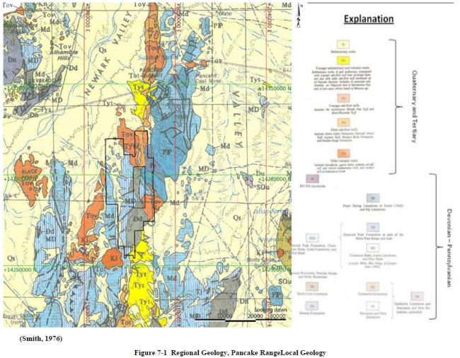
Regional Geology
|
The Pan property is located in the core of the northern portion of the Pancake Range of east-central Nevada. The Pancake Range is part of the Basin and Range Province, a large physiographic region characterized by a series of normal faults expressed as a sequence of north-south trending narrow mountain ranges separated by flat, arid valleys. The Pancake Range is approximately 85 miles long and 8 to 10 miles wide and is composed of Paleozoic carbonate and clastic sedimentary rocks, Cretaceous igneous intrusives, and Tertiary volcanics. A regional geologic map of the northern Pancake Range is presented as Figure 7-1.
| December 19, 2011 | 23 | |
| Midway Gold Corp. | Geological Setting and Mineralization |
| Pan Gold Project Feasibility Study | NI 43-101 Technical Report |
| December 19, 2011 | 24 | |
| Midway Gold Corp. | Geological Setting and Mineralization |
| Pan Gold Project Feasibility Study | NI 43-101 Technical Report |
The Pan property is bounded to the east and west by the Newark Valley. Devonian, Carboniferous, and Permian carbonate and clastic sedimentary rocks form the core of the Pancake Range, and are exposed in bedrock outcrop in the project area. A representative stratigraphic section is presented as Figure 7-2.

A Cretaceous intrusion of quartz monzonite is present just south of the Pan Project area and a quartz monzonite sill intrudes along an east-west fault in the south central portion of the property. These intrusives are assumed to be age related to the Seligman and Monte Cristo stocks, which outcrop in the Mount Hamilton area to the east of the Pan property. The Seligman and Monte Cristo stocks may have provided a heat source for the Pan mineral deposits. Post-
| December 19, 2011 | 25 | |
| Midway Gold Corp. | Geological Setting and Mineralization |
| Pan Gold Project Feasibility Study | NI 43-101 Technical Report |
mineral Tertiary volcanic rocks, including basalt and quartz latite airfall tuff, nonconformably cap the Devonian to Permian sedimentary bedrock geology in the vicinity of the Pan Project.
|
7.2
|
Property Geology
|
The geology of the Pan property is dominated by Devonian to Permian carbonate and clastic sedimentary rocks cut by the Pan fault, a steeply west dipping normal fault that trends north-south. The Pan fault juxtaposes gently west dipping sedimentary units on the west side of the fault, and steeply northeast dipping sedimentary units on the east side. Post-mineral Tertiary volcanic rocks nonconformably overlie the faulted Devonian through Permian sedimentary units. Individual lithologic units identified at the project site are described below, from oldest to youngest.
|
7.2.1
|
Lithological Units
|
|
7.2.1.1
|
Simonson Dolomite (Ds) - Devonian
|
The Simonson Dolomite is the lowermost lithologic unit intersected by drilling at the Pan property. This unit is not exposed on the surface. Thickness ranges from 500 to 1,300 ft thick in White Pine County (Smith, 1976) but only the top portion of the dolomite has been drilled at South Pan. The dolomite is a light gray, massively bedded unit.
|
7.2.1.2
|
Devils Gate Limestone (Dd) - Late Devonian
|
The oldest lithologic unit exposed in the northern Pancake Range is the Late Devonian Devil’s Gate Limestone. This unit is massive to thinly bedded, medium to dark gray, fine to coarse grained limestone. Thickness of the unit ranges from about 1000 ft to 2500 ft locally. The Devil’s Gate Limestone is the secondary host of gold mineralization at the Pan property.
|
7.2.1.3
|
Pilot Shale (MDp) - Late Devonian to Early Mississippian
|
The Pilot Shale has an upper series of thinly interbedded dolomitic and calcareous siltstone and silty shale, and a lower section of more thickly bedded calcareous siltstone with local limestone beds. The unit ranges in thickness from about 300 to 900 ft, but locally thickens structurally along the Pan fault. Silicified and argillized Pilot Shale is the primary host of gold mineralization at the Pan property.
|
7.2.1.4
|
Joana Limestone (Mj) - Mississippian
|
The Joana Limestone is a gray, medium grained, unevenly bedded limestone with abundant fossil fragments and detrital limestone interbeds. Reported fossil types include echinoderm, bryozoans, foraminifera, algae, and crinoids. Locally, light brown calcareous sandstone is present at the base of the unit. Thickness of the Joana Limestone is typically less than 150 ft at the Pan property, though the total thickness reportedly ranges from 90 to 500 ft throughout the county (Smith, 1976).
| December 19, 2011 | 26 | |
| Midway Gold Corp. | Geological Setting and Mineralization |
| Pan Gold Project Feasibility Study | NI 43-101 Technical Report |
|
7.2.1.5
|
Chainman Shale (Mc) - Mississippian
|
The Chainman Shale consists of dark gray to black shale with thin interbeds of olive gray silty shale and siltstone. Thickness of the unit ranges from 1000 to 2000 ft (Smith, 1976) and is about 1000 ft at the Pan property.
|
7.2.1.6
|
Diamond Peak Formation (Md) - Mississippian
|
The Diamond Peak Formation consists of medium beds of coarse grained, quartz-rich sandstone and olive gray siltstone overlain by thick to massive conglomerate. Thickness of the Formation ranges from less than 1,000 to 3,700 ft, and is about 2400 ft in the Pan Project area.
|
7.2.1.7
|
Ely Limestone (Pe) - Pennsylvanian
|
The Ely Limestone is a medium bedded, coarsely crystalline, medium gray limestone with local interbeds of siltstone and chert. Thickness ranges from 1800 to 3000 ft, and averages about 2000 ft in the Pancake Range.
|
7.2.1.8
|
Rib Hill Siltstone - Permian
|
The Rib Hill Siltstone is a thinly bedded, quartz-rich, calcite-cemented siltstone with sandstone interbeds and high iron oxide and carbonate content. Thickness ranges from 800 to 1,400 ft (Smith, 1976). Thickness at the Pan property is unknown as a full section is not exposed, but based on limited drilling is greater than 600 ft.
|
7.2.1.9
|
Kaibab Limestone - Permian
|
The Kaibab Limestone is a thick-bedded limestone with reportedly high fossil content. This unit is found in isolated outcrops throughout White Pine County (Smith, 1976) at thicknesses ranging from 50 to 200 ft. True thickness at the Pan property is unknown as only two isolated outcrops of lower Kaibab are exposed.
|
7.2.1.l0
|
Intrusives - Cretaceous
|
In the Mount Hamilton area to the east, both the Seligman and Monte Cristo stock have been age dated at 90.4 to 128.0 million years (Adair and Stringham, 1960). A small intrusive body south of the Pan property, the Pancake stock, was age dated at 108 million years (Smith, 1976). The Pancake stock ranges in composition from quartz monzonite to granodiorite. A quartz monzonite sill intrudes along an east-west fault in the south-central portion of the property.
| December 19, 2011 | 27 | |
| Midway Gold Corp. | Geological Setting and Mineralization |
| Pan Gold Project Feasibility Study | NI 43-101 Technical Report |
|
7.2.1.11
|
Volcanic Units (Tv) - Tertiary
|
Tertiary volcanics exposed in the northern Pancake Range include a lower (Oligocene) quartz latite airfall tuff (50-200 ft thick) and an upper basalt flow (50-100 ft thick). Infrequent quartz-rich rhyodacite of similar age is present along the northern portion of the Pan property. These units are post mineral and overlie projections of gold mineralization and structure to the north and south of the known gold deposits at Pan.
|
7.2.2
|
Structural Geology
|
The geology of the Pan property is structurally dominated by the north-south trending Pan fault, a high angle fault with possible right lateral offset. Based on drill intercepts and interpretation, the fault dips between 80° to 85° west. On the west side of the fault, Devonian through Mississippian stratigraphy dips 10° to 30° westward. On the east side of the fault, Devonian through Permian stratigraphy dips 65° to 70° to the northeast.
The stratigraphic units on the east side of the Pan fault comprise the southwest limb of a northwest trending syncline. The Pan fault is recognizable in the field by the juxtaposition of younger sedimentary rocks to the east against older sedimentary rocks to the west, and can be tracked north until covered by Tertiary volcanic units. To the south, the Pan fault appears to horsetail with splays arcing to the southeast until covered by post-mineral volcanic units.
The terrain west of the Pan fault is cut by a number of northeasterly trending high angle faults with varying displacement senses. There are also a number of northerly trending faults, which may include high angle, dip-slip faults, and low angle, easterly-directed thrust faults. Thrust faulting reasonably accounts for the multiple repetitions of the Devils Gate Limestone and Pilot Shale, the principal hosts of mineralization.
Considerable breccia is present along and in proximity to the Pan fault and other structures to the west. The breccias host a substantial portion of the gold resource at the Pan Project and are interpreted as dissolution collapse breccia and hydrothermal breccia formed during the mineralizing event. Narrow breccia zones in the Devils Gate Limestone expand in lateral dimensions in the overlying Pilot Shale. The resultant geometry is one of elongate pods of breccia extending along structural trends within the Pilot Shale, with the breccia body necking down at depth in the Devils Gate Limestone. The breccia varies from clast to matrix supported, and contains angular to subrounded sedimentary fragments. Associated crackle breccia, wherein the rock is shattered but fragments remain roughly in place and not rotated, occurs marginal to or as relicts within the breccia bodies, and is altered and mineralized in a manner similar to the dissolution/hydrothermal breccia.
|
7.3
|
Mineralization
|
The Pan Project can be separated into three general geographic zones: North Pan, South Pan, and Central Pan. Gold mineralization at the Pan Project is encountered in all three zones.
| December 19, 2011 | 28 | |
| Midway Gold Corp. | Geological Setting and Mineralization |
| Pan Gold Project Feasibility Study | NI 43-101 Technical Report |
Mineralization is both structurally and stratigraphically controlled, occurring primarily in breccias along the trend of the Pan fault, within high-angle northwest- and northeast-trending structural zones, and within calcareous shale beds. Collapse breccias in the upper Devil’s Gate Limestone and pipe-like breccia bodies that developed within the Devil’s Gate Limestone below the collapse breccia zones likely acted as conduits for gold-bearing hydrothermal solution.
In South Pan, mineralization occurs in breccias developed within both the Pilot Shale and the Devil’s Gate Limestone, distributed within a broad zone of silicification and calcite veining associated with the Pan fault zone, and appears to be stratabound in limestone and shale along the limbs of an anticline dissected by the Pan fault. The contact between the Pilot Shale and Devil’s Gate Limestone hosts mineralization along strike within both the Central and North Pan zones. These occurrences are described as Carlin-style, epithermal, disseminated, sediment-hosted systems.
Mineralization is primarily hosted in structurally controlled dissolution breccias along sub-vertical faults. Dissolution breccias formed along the Pan fault as well as minor cross faults in both North and South Pan. Wide zones of breccia developed in the Pilot Shale with narrower zones occurring in the Devils Gate Limestone.
Stratigraphically controlled mineralization occurs along argillized contacts between the Pilot Shale and Devils Gate Limestone. Better mineralization along these contacts tends to be hosted within the Pilot Shale. This style of mineralization is less common but is significant in the Wendy area of South Pan and in the Black Stallion and Syncline areas of Central Pan.
Estimation domains were delineated within the North Pan, South Pan, and Central Pan zones based on the style and orientation of mineralization in each area. Both styles of mineralization can be present within the same zone, though one is usually dominant. The search parameters within each domain were restricted to those most appropriate for the dominant style of mineralization.
|
7.3.1
|
Alteration
|
Alteration associated with the Pan deposits is typical of Carlin-style gold systems, and includes silicification, argillization, decalcification, and oxidation. Breccia bodies may be silicified (jasperoid) or argillized and can contain variably altered fragments, including silicified, clay altered, and/or decalcified fragments. The Pilot Shale- Devils Gate Limestone contact may be argillized and/or decalcified.
Silicification is characterized by multi-phase breccia and passive silica flooding along bedding and structures. Silicification occurs in breccia zones and in the Pilot Shale, and small zones have also been identified in the Devils Gate Limestone. Minor quartz veining has been reported in the North Pan zone, particularly in association with the Campbell Jasperoid.
| December 19, 2011 | 29 | |
| Midway Gold Corp. | Geological Setting and Mineralization |
| Pan Gold Project Feasibility Study | NI 43-101 Technical Report |
Decalcification of both the Devils Gate Limestone and calcareous siltstones of the Pilot Shale is spatially associated with mineralization encountered at Pan. Decalcification results in a sanded, punky texture, especially in lithologic units with high original carbonate content.
Mineralization at Pan occurs in strongly oxidized rock. Oxidation is prevalent throughout each of the zones with strong development of iron oxides (hematite and limonite). Liesegang banding formed in the Pilot Shale in association with oxidation. Sulphide minerals have rarely been described in drill logs at Pan, and are not associated with the gold mineralization.
The bulk of the mineralized area contains elevated barite levels, typically above 0.2%. Hydrothermal barite veins are present in the southeast portion of the property in association with the old Cue Ball Barite Mine, briefly worked in the 1970s.
|
7.3.2
|
Geometry of Mineralization
|
Gold deposits at the Pan Project generally occur as elongate pods in association with structures and dissolution/hydrothermal breccia bodies hosted by the Pilot Shale and, to a lesser extent, the Devils Gate Limestone. Gold deposits also occur as more tabular bodies in deposits hosted by altered and mineralized sedimentary horizons. Cross sections typical of the North and South Pan zones are shown on Figures 7-3 and 7-4.
North Pan mineralization is predominantly hosted in breccias developed in the moderately folded Pilot Shale along the Pan fault and other structures to the west. At present, very little mineralization has been identified in the Devils Gate Limestone, in part due to the lack of drilling which intersects the Pilot Shale-Devil’s Gate contact. Mineralization occurs along a north-south trend approximately 5,000 ft long and 500 to 1,000 ft wide. Gold mineralization has been identified to depths up to 650 ft, but remains open at depth and to the north under volcanic cover.
The Central Pan zone contains mostly sub-horizontal, tabular mineralization hosted along the Pilot Shale- Devils Gate Limestone contact. Mineralization in the Black Stallion and Syncline areas is dominantly hosted in folded and faulted Pilot Shale, but also occurs in Devils Gate Limestone. This area of mineralization is relatively small, but there is some potential for expansion with additional drilling.
In the South Pan zone, mineralization has been identified along the north-south trend of the Pan fault for approximately 5,000 ft, ranging in width from 300 to 700 ft. To the east of the Pan fault, sedimentary units dip 30° to 70° to the northeast, with pronounced fault drag against major structures. Gold occurs in breccias composed of shattered and clay altered, decalcified Devils
| December 19, 2011 | 30 | |
| Midway Gold Corp. | Geological Setting and Mineralization |
| Pan Gold Project Feasibility Study | NI 43-101 Technical Report |
Gate Limestone. Rock types are typically decalcified limestone and, where present, silicified and argillized Pilot Shale. A significant portion of the Pilot Shale at South Pan is eroded away. Mineralization in the Barite area is structurally dominated and mineralization occurs along the Pan fault in breccias of both the Pilot Shale and Devil’s Gate Limestone. Mineralization in the Wendy area is stratigraphically dominated, more tabular in shape, and is controlled by alteration of the Pilot Shale- Devils Gate Limestone contact. Known mineralization in this zone is open to the east and to the south under volcanic cover.
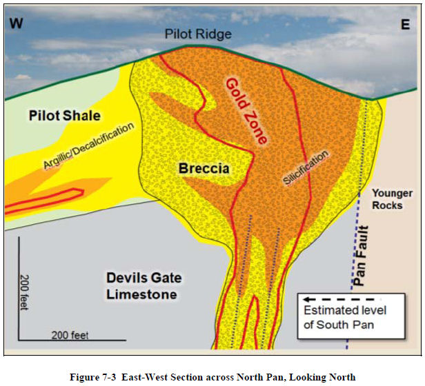
| December 19, 2011 | 31 | |
| Midway Gold Corp. | Geological Setting and Mineralization |
| Pan Gold Project Feasibility Study | NI 43-101 Technical Report |

| December 19, 2011 | 32 | |
| Midway Gold Corp. | Deposit Types |
| Pan Gold Project Feasibility Study | NI 43-101 Technical Report |
|
8
|
DEPOSIT TYPES
|
MIDWAY interprets gold deposits at the Pan Project to be Carlin-style, epithermal, disseminated gold hosted in Devonian and Mississippian sedimentary units. This type of system falls under the general classification of low sulfidation epithermal deposits. Gold particles occur as micron to submicron size disseminations. Visible or coarse gold is not common in this type of deposit, and has not been observed at Pan.
Controls on mineralization in Carlin-style systems and at the Pan Project include both structure and stratigraphy. Gold mineralization is generally distributed along high-angle faults, and in a more tabular fashion subparallel to stratigraphy. Dissolution breccias developed in association with faults at the Pan Project serve as the primary host for gold mineralization. Additional mineralization is hosted in favorable stratigraphy, primarily in the lower Pilot Shale and to a lesser extent, the upper Devil’s Gate Limestone.
Similar type gold deposits in the surrounding area include Bald Mountain, Maverick Springs, Emigrant Springs, and Midway Gold Corp.’s Gold Rock deposit.
| December 19, 2011 | 33 | |
| Midway Gold Corp. | Exploration |
| Pan Gold Project Feasibility Study | NI 43-101 Technical Report |
|
9
|
EXPLORATION
|
Exploration at the Pan Project is a comprehensive effort utilizing a variety of methodologies, including:
|
●
|
Geochemical sampling
|
|
●
|
Geophysics
|
|
●
|
Surface and subsurface geologic mapping
|
|
●
|
Drilling within the known resource area
|
|
●
|
Drilling on exploration targets
|
|
9.1
|
Previous Operators Exploration Work
|
Previous exploration work includes geologic mapping, metallurgy, geochemical sampling, geophysical surveys, and drilling. Exploration conducted by previous operators is described in detail in previously filed technical reports, including Gustavson’s 2011 Preliminary Feasibility Study.
|
9.2
|
MIDWAY Exploration Work
|
Since acquiring the Pan property in 2007, MIDWAY has conducted exploration using a number of different investigative techniques. Drill targets proximal to North and South Pan and additional exploration targets throughout the project area have been identified based on the results of surface geochemical surveys, chip sample analysis, geologic mapping, and geophysical surveys.
|
9.2.1
|
Surface Geochemistry
|
Soil sampling on 100 x 200 and 200 x 200 ft grids was carried out by Pan Nevada (2006) and MIDWAY (2007 and 2008). This grid covered the majority of the property and consisted of collection and analysis of 9,525 soil samples. Soils were sieved to the -10+80 mesh size fraction and assayed for gold at ALS Chemex. Assay for gold was accomplished by standard fire assay methods on a 30g subsample, and for an additional 50 elements by aqua regia digestion of a 0.5-gram subsample and inductively coupled plasma (ICP) finish.
|
9.2.2
|
Rock Samples
|
Between 2003 and 2008, MIDWAY and Pan Nevada collected and analyzed a total of 786 surface rock samples. Individual chip samples were collected from outcrops scattered throughout the property, and 10 ft continuous chip samples were collected from Pilot Ridge in the south central portion of North Pan. Samples were collected during geologic reconnaissance traverses, prospect mapping, and target delineation. Rock chips were crushed to 70% passing 2mm with a nominal 250 gram split, pulverized to 85% passing 75μm, and were then assayed by standard fire
| December 19, 2011 | 34 | |
| Midway Gold Corp. | Exploration |
| Pan Gold Project Feasibility Study | NI 43-101 Technical Report |
assay methods by ALS Chemex. Only a small number of samples were analyzed for an additional 50 elements by aqua regia digestion of a 0.5-gram subsample and ICP finish.
|
9.2.3
|
Geologic Mapping
|
Latitude produced a geologic map of the Pan property at a scale of 1:6000 in 2001, focusing on North and South Pan. MIDWAY completed reconnaissance mapping, scale 1:12000 and more detailed local mapping, scale 1:6000, in 2007 in order to extend map coverage over the entire Pan Project area. This work helped to clarify the geologic setting, identify structural trends, and indicate prospective areas for additional exploration.
|
9.2.4
|
Geophysical Surveys
|
MaGee Geophysical Services conducted a ground gravity survey at the Pan property in 2008. J.L. Wright Geophysics of Spring Creek, Nevada, interpreted the results of the survey, which identified several major structural features and were used to identify target areas for future drilling.
| December 19, 2011 | 35 | |
| Midway Gold Corp. | Drilling |
| Pan Gold Project Feasibility Study | NI 43-101 Technical Report |
|
10
|
DRILLING
|
|
10.1
|
Introduction
|
Gustavson has validated 975 holes drilled at the Pan property since 1978. Historic drilling campaigns carried out by operators other than MIDWAY account for 766 of the total number of holes. Historic drilling is described in detail in previously filed reports, including Gustavson’s 2010 Preliminary Feasibility Study.
|
10.2
|
Drilling by Midway Gold Corp.
|
As of September 1, 2011, MIDWAY has drilled a total of 209 holes for a total of 95,394 ft. Of the 209 holes drilled by MIDWAY, 195 were drilled using reverse circulation, and 14 are diamond core holes. Drilling exploration conducted by MIDWAY is summarized in Table 10-1, and drill hole distribution is shown on Figure 10-1.
Table 10-1 Midway Dilling Exporation Summary
|
Exploration
Program (Year) |
Number of
Holes Drilled |
Total
Footage |
Type of
Drill Hole |
|
2007-2008
|
162
|
61,875
|
RC
|
|
2010
|
14
|
5774.5
|
Core
|
|
2011
|
33
|
27,744.5
|
RC
|
MIDWAY completed 33 reverse circulation (RC) holes in 2011. Data from these holes was added to the project database, and was used to update the Pan mineral resource estimate. Drill hole information from drilling completed from January through June 2011 is summarized in Table 10-2.
| December 19, 2011 | 36 | |
| Midway Gold Corp. | Drilling |
| Pan Gold Project Feasibility Study | NI 43-101 Technical Report |
Table 10-2 2011 Drill Hole Summary
|
Area
|
Northing (ft)
|
Easting (ft)
|
Northing (m)
|
Easting (m)
|
Elevation (ft)
|
TD
|
Date Completed
|
Dip
|
Azimuth
|
Purpose
|
|
|
PN11-01
|
S.Dep
|
14270552.22
|
1998752.916
|
4349673.016
|
609221.1072
|
6977.43
|
450
|
1/19/2011
|
-65
|
275
|
Resource
|
|
PN11-02
|
S.Dep
|
14272129.29
|
1998525.103
|
4350153.708
|
609151.6697
|
6831.36
|
560
|
1/29/2011
|
-75
|
270
|
Resource
|
|
PN11-03
|
S.Dep
|
14272211.68
|
1998838.24
|
4350178.82
|
609247.114
|
6796.22
|
570
|
2/3/2011
|
-70
|
270
|
Resource
|
|
PN11-04
|
S.Dep
|
14272182.5
|
1999069.96
|
4350169.926
|
609317.7424
|
6838.91
|
800
|
2/13/2011
|
-90
|
None
|
Resource
|
|
PN11-05
|
S.Dep
|
14271994.47
|
1999047.982
|
4350112.615
|
609311.0435
|
6834.19
|
654
|
2/16/2011
|
-90
|
None
|
Resource
|
|
PN11-06
|
S.Dep
|
14272409.22
|
1998944.925
|
4350239.031
|
609279.6317
|
6791.72
|
680
|
2/23/2011
|
-90
|
None
|
Resource
|
|
PN11-07
|
S.Dep
|
14272420.96
|
1998805.859
|
4350242.609
|
609237.2443
|
6777.94
|
600
|
2/26/2011
|
-90
|
None
|
Resource
|
|
PN11-08
|
S.Dep
|
14271392.6
|
1999364.466
|
4349929.164
|
609407.5081
|
6883.61
|
620
|
3/2/2011
|
-90
|
None
|
Resource
|
|
PN11-09
|
S.Dep
|
14271867.75
|
1999245.998
|
4350073.99
|
609371.3989
|
6880.66
|
750
|
3/12/2011
|
-90
|
None
|
Resource
|
|
PN11-10
|
S.Dep
|
14271663.27
|
1999271.248
|
4350011.665
|
609379.0951
|
6875.71
|
750
|
3/14/2011
|
-90
|
None
|
Resource
|
|
PN11-11
|
S.Dep
|
14273269.31
|
1998896.799
|
4350501.187
|
609264.9629
|
6730.77
|
700
|
3/17/2011
|
-90
|
None
|
Resource
|
|
PN11-17
|
Heap
|
14275730.44
|
1994893.624
|
4351251.341
|
608044.7927
|
6744.17
|
1300
|
3/23/2011
|
-90
|
None
|
Condemnation
|
|
PN11-12
|
S.Dep
|
14273236.97
|
1998700.482
|
4350491.329
|
609205.1253
|
6749.03
|
700
|
3/27/2011
|
-80
|
278
|
Resource
|
|
PN11-13
|
S.Dep
|
14272615.5
|
1998711.867
|
4350301.905
|
609208.5955
|
6772.67
|
600
|
3/30/2011
|
-75
|
133
|
Resource
|
|
PN11-18
|
Heap
|
14274966.78
|
1995829.893
|
4351018.577
|
608330.168
|
6550.17
|
1435
|
3/30/2011
|
-70
|
133
|
Condemnation
|
|
PN11-14
|
S.Dep
|
14273638.6
|
1998727.974
|
4350613.747
|
609213.5049
|
6729.41
|
700
|
4/6/2011
|
-75
|
220
|
Resource
|
|
PN11-15
|
S.Dep
|
14273935.52
|
1998425.131
|
4350704.248
|
609121.1982
|
6753.79
|
780
|
4/10/2011
|
-75
|
90
|
Resource
|
|
PN11-19
|
Heap
|
14274670.99
|
1996129.294
|
4350928.42
|
608421.4257
|
6543.61
|
1450
|
4/10/2011
|
-70
|
130
|
Condemnation
|
|
PN11-16
|
S.Dep
|
14273445.42
|
1998612.7
|
4350554.865
|
609178.3693
|
6755.6
|
700
|
4/13/2011
|
-90
|
None
|
Resource
|
|
PN11-20
|
Heap
|
14274787.34
|
1995969.275
|
4350963.883
|
608372.6518
|
6531.94
|
800
|
4/13/2011
|
-80
|
130
|
Condemnation
|
|
PN11-30
|
S.Pan
|
14273648.92
|
1998516.91
|
4350616.892
|
609149.1725
|
6751.3
|
690
|
4/20/2011
|
-90
|
None
|
Resource
|
|
PN11-31
|
N.Rock Pile
|
14280607.49
|
1997928.55
|
4352737.868
|
608969.84
|
6667.53
|
650
|
4/22/2011
|
-70
|
90
|
Condemnation
|
|
PN11-21
|
Heap
|
14275690.93
|
1996341.796
|
4351239.298
|
608486.1964
|
6581.58
|
1500
|
4/23/2011
|
-80
|
90
|
Condemnation
|
|
PN11-22
|
Heap
|
14276750.67
|
1996346.337
|
4351562.307
|
608487.5805
|
6592.32
|
1500
|
4/26/2011
|
-75
|
90
|
Condemnation
|
|
PN11-32
|
E.Heap
|
14272719.63
|
1992674.556
|
4350333.644
|
607368.4194
|
6393.96
|
850
|
4/26/2011
|
-70
|
90
|
Condemnation
|
|
PN11-33
|
S.Rock Pile
|
14271400.53
|
1996667.375
|
4349931.581
|
608585.4331
|
6687.87
|
900
|
5/4/2011
|
-90
|
0
|
Condemnation
|
|
PN11-23
|
Heap
|
14274621.03
|
1994159.031
|
4350913.192
|
607820.8883
|
6447.69
|
1418.5
|
5/9/2011
|
-70
|
90
|
Condemnation
|
|
PN11-34
|
S.Rock Pile
|
14269746.67
|
1997203.947
|
4349427.484
|
608748.9805
|
6704.7
|
497
|
5/9/2011
|
-70
|
90
|
Condemnation
|
|
PN11-24
|
E.Heap
|
14275327.94
|
1992689.707
|
4351128.658
|
607373.0374
|
6363.27
|
1200
|
5/19/2011
|
-80
|
90
|
Condemnation
|
|
PN11-35
|
Heap
|
14272804.65
|
1995020.974
|
4350359.558
|
608083.609
|
6538.05
|
830
|
5/23/2011
|
-75
|
90
|
Condemnation
|
|
PN11-36
|
Heap
|
14272636.4
|
1996272.06
|
4350308.28
|
608464.939
|
6588.52
|
450
|
5/23/2011
|
-70
|
90
|
Condemnation
|
|
PN11-37
|
Heap
|
14273560.7
|
1994195.49
|
4350590
|
607832
|
6595
|
830
|
6/4/2011
|
-70
|
90
|
Condemnation
|
|
PN11-29
|
Heap
|
14277054.78
|
1992404.15
|
4351655
|
607286
|
6415
|
830
|
6/5/2011
|
-70
|
90
|
Condemnation
|
|
33
|
Total Holes
|
Total:
|
27744.5
|
Total Condemnation
|
16440.5
|
||||||
|
17
|
Resource holes
|
June Footage
|
1660
|
Total Resource
|
11304
|
||||||
|
16
|
Condemnation
|
| December 19, 2011 | 37 | |
| Midway Gold Corp. | Drilling |
| Pan Gold Project Feasibility Study | NI 43-101 Technical Report |

| December 19, 2011 | 38 | |
| Midway Gold Corp. | Drilling |
| Pan Gold Project Feasibility Study | NI 43-101 Technical Report |
|
10.2.1
|
Drilling Procedures and Conditions
|
Drilling conditions at Pan are favorable given the moderate terrain and existing road network. Drill sites are prepared by digging a sump and leveling a pad for the drill rig, if necessary. Holes are generally collared in bedrock and completed above the water table. Historical drilling results and recent hydrologic data indicate that the water table is at least 1,000 ft below ground surface.
RC and rotary methods were used for nearly all drilling at Pan to date. RC drilling was generally carried out using a down hole hammer with hammer bits ranging in diameter from 4 ½ to 5 ¾”. The use of Tricone bits was limited to a small number of holes where drilling conditions prevented penetration and sample recovery using the down hole hammer. These holes were generally cased to depths of 10 to 20 ft.
Most of the core holes drilled at the Pan property were advanced using HQ (2½ inch) size core from ground surface and with no precollars. Core recovery was generally good, but core loss increased in highly fractured and brecciated rock commonly associated with mineralization. Core recovery is discussed in further detail below.
|
10.2.2
|
Drill hole Collar Surveys
|
A digital database of collar locations for the Pan Project was developed by MDA for the 2005 resource estimate. This data was physically compared to all known drill logs to confirm locations and no errors were identified.
A licensed surveyor surveyed all MIDWAY holes. The UTM NAD 83 coordinate locations of MIDWAY holes were compared to associated proposed locations, topography, and GPS coordinates to evaluate accuracy and identify errors.
Geologic logs were completed for each drill hole and are compiled in the Pan Project database. Since 2007, MIDWAY geologists have logged core data directly into Microsoft Excel® spreadsheets using an on-site laptop station during drilling. The logging terminology for formation, lithology, alteration, oxidation, and waste type were preapproved, and any changes to the form required the approval of the project manager. MIDWAY did collect core samples from the 2010 and 2011 drilling programs. Core samples from previous operators have either been consumed or lost. All project drill logs are printed and catalogued by hole name, together with related drill information, in binders maintained by MIDWAY. All collar and drill log information was imported into a secure Microsoft Access® database, stored on the main project computer, and backed up to the corporate server. For security, access to the primary database is limited to the MIDWAY project manager.
|
10.2.3
|
Down hole Surveys
|
Down hole surveys were completed at Pan for all MIDWAY drilling.
| December 19, 2011 | 39 | |
| Midway Gold Corp. | Drilling |
| Pan Gold Project Feasibility Study | NI 43-101 Technical Report |
|
10.2.4
|
Extent of Drilling
|
Drill hole spacing at ground surface ranges from 100 ft to over 400 ft, but is generally on nominal 100 ft centers. The majority of the drill holes (65%) were advanced vertically. Approximately half of the holes drilled at an angle were oriented westerly, and one third of the angled drill holes were oriented easterly. Intercepts equal to or greater than 20 ft with grades equal to or greater than 0.010 ozAu/st were encountered in 464 of the total 864 holes drilled at the property since 1978. The intercept downhole thickness does not necessarily represent the true thickness of mineralization. With few exceptions, drilled lengths are greater than true thicknesses.
|
10.2.5
|
MIDWAY Data Compilation and Grid Conversion
|
For the 2005 resource estimate, MDA converted the Pan database from a local coordinate system to NAD83, Zone 11 UTM coordinates, expressed in US ft.
|
10.3
|
Sampling Method and Approach
|
The Pan drill hole database includes sample data from reverse circulation, core, and rotary drilling. Drilling was performed by a variety of operators during a total of nine drilling campaigns over a 20-year period. Drill spacing is on nominal 100 ft centers at North Pan and Central Pan, and nominal 165 ft centers at South Pan. Drill spacing tighter than 100 ft centers occurs in some areas of mineralization at North Pan and Central Pan. Most RC and rotary samples (99%) were collected on 5 ft intervals, and all core samples were collected on intervals of 5 ft or less. Very little documentation is available on drilling and sampling procedures employed prior to 2004. However, the drilling was conducted by companies experienced in exploration and production and is considered reliable.
MIDWAY performed RC drilling at Pan in 2007 and 2008, and again in 2011. The drilling was performed wet, with water injection between 1 and 2 gallons per minute. Groundwater was encountered in the deeper holes, the deepest of which was drilled to a depth of 1500 ft.
RC samples were collected every 5 ft by a designated and trained sampler provided by the drilling contractor. Cuttings from each interval were passed through a cyclone and into a rotary vane splitter with 16 openings. The number of splitter openings was adjusted to maintain a roughly constant sample size of 7 kg. A representative split from the discharge material was placed into a plastic RC chip tray for geological logging. The chip tray was marked with the drill hole name and downhole interval.
RC samples were collected in large micro-pore bags marked with the sample number and suspended from the discharge tube of the splitter. Overflow was minimal because of low water injection rates and lack of groundwater. Nominal sample weight was 5 to 10 kg.
| December 19, 2011 | 40 | |
| Midway Gold Corp. | Drilling |
| Pan Gold Project Feasibility Study | NI 43-101 Technical Report |
RC samples were allowed to drain at the drill site and were taken to a Eureka (2007-2008) or Ely (2010-2011) office facility at the end of each day by MIDWAY personnel. Samples were stored in secure bins until transported to an assay laboratory in Elko or Winnemucca by certified laboratory personnel.
During the 2010 drilling campaign carried out by MIDWAY, core was placed in core boxes by the drill crew at the drill site. Core boxes were picked up from the rig daily and transported to the MIDWAY logging facility. Geotechnical measurements including RQD and rock strength data were collected before the core was placed in the core box. Then the core was washed and photographed with color and scale cards included. A geologist selected appropriate intervals for sampling, and logged and photographed the core prior to splitting or sampling. The preferred sample interval and maximum sample length was 5 ft. Smaller intervals were used where significant geological breaks occurred, but not less than 1 ft.
Core was split using a diamond saw where competent. A manual splitter was used for core not suitable for sawing. In soft clay zones, a putty knife was used to split the core. A quarter split was used for assay purposes. The remaining core was sampled for metallurgical and waste rock characterization testing. Skeleton core, a small piece every 2-3 ft, was saved for the core archive. The remainder of the core was sent to the lab.
ALS Chemex picked up the assay samples from the Ely office and transported them to a Nevada prep facility. For quality assurance and quality control, standards and blanks were inserted into the sample stream at a rate of one for every 25 project samples. Commercial Standard Reference Materials (SRM’s) and blanks were acquired from Shea Clark Smith in 2007 and 2008 and from Ore Research & Exploration (Ore Research) of Bayswater North, Australia in 2010 and 2011. SRM’s grading 0.01 opt Au and 0.03 opt Au were alternated with blanks in the sample stream.
| December 19, 2011 | 41 | |
| Midway Gold Corp. | Sample Preparation, Analyses, and Security |
| Pan Gold Project Feasibility Study | NI 43-101 Technical Report |
|
11
|
SAMPLE PREPARATION, ANALYSES, AND SECURIITY
|
Based on available assay certificate information, samples collected during the ten drilling campaigns at Pan were analyzed for gold by fire assay (AuFA) and/or gold cyanide extraction assay (AuCN). Gustavson and Dr. Baker consider the sample preparation, security, and analytical procedures to be adequate for use in resource and reserve estimation. Table 11-1 summarizes the type of assay data currently in the database.
Table 11-1 Drill Data by Analytical Method
|
Company
|
Number AuFA
Determinations |
Number AuCN
Determinations |
AuCN/AuFA
Pairs |
AuCN
Only |
Percent of Data
Represented by AuCN Data |
|
Amselco
|
610
|
3,641
|
303
|
3,338
|
84.6
|
|
Hecla
|
121
|
0
|
0
|
0
|
0
|
|
Echo Bay
|
3,980
|
0
|
0
|
0
|
0
|
|
Alta Bay
|
6,288
|
13,318
|
6,284
|
7,034
|
52.8
|
|
Latitude
|
2,874
|
0
|
0
|
0
|
0
|
|
Castleworth/ Pan Nevada
|
13,738
|
254
|
254
|
0
|
0
|
|
Southwest
|
282
|
0
|
0
|
0
|
0
|
|
MIDWAY
|
26,099
|
1,190
|
1,190
|
0
|
0
|
|
TOTAL
|
53,992
|
18,403
|
8,031
|
10,372
|
19.2
|
|
11.1
|
Sample Preparation and Analysis Procedures
|
RC samples collected by MIDWAY were processed by ALS Chemex in Elko and Winnemucca, and by SGS Laboratories in Elko, Nevada. Standards and blanks developed and/or purchased by MIDWAY were included in the sample sets dispatched to the laboratory. At the labs, samples were crushed to 70% passing -6mm, split to 250g using a riffle splitter, then pulverized to 85% passing 75 microns. Pulps were analyzed using 30g fire assay with an AA finish. Higher grade samples (>0.291 ozAu/st) received a gravimetric finish. For samples returning greater than 300 ppb Au, a cyanide leach analysis was performed. A one-hour cyanide digestion was completed on a 30g sample pulp, followed by AA determination of gold content in the pregnant cyanide solution. MIDWAY data from 9,957 sample intervals with AuFA determinations, and 1,035 sample intervals with paired AuCN information, are included in the Pan database.
| December 19, 2011 | 42 | |
| Midway Gold Corp. | Data Verification |
| Pan Gold Project Feasibility Study | NI 43-101 Technical Report |
|
12
|
DATA VERIFICATION
|
MDA (2005) and AMEC (2008) verified exploration and drilling data through 2007. Both companies found the logs, surveys, and assays in the Pan mineral resource database accurately represent the source documentation. MIDWAY did a complete check of the Pan database in 2007; MIDWAY reinterpreted drill logs and created new interpretations of geology and alteration on cross sections in 2010 and 2011. Gustavson generated a new model based on the updated geologic sections including lithology and alteration.
MIDWAY personnel verified exploration data collected after January 1, 2008, including checking logs, surveys, and assays. 100% of the 2008 data matches the original information, constituting an error of less than 0.01%. Gustavson independently verified exploration data collected from 2009 through the effective date of this report, September 1, 2011, by checking logs and assay data against core samples, field checking survey data, and comparing assay data reported by MIDWAY to laboratory assay certificates. Gustavson finds the quality of data collected to date adequate for use in estimating the mineral resources of the Pan Project.
|
12.1
|
Check Assays
|
In 2007, MIDWAY conducted a rig duplicate program, collecting a duplicate sample from most of the holes completed during the year. Duplicate samples were collected on site approximately every 100 ft. The original assay and duplicate samples were then sent to the same laboratory for analysis. Duplicate samples were split and analyzed using the same procedures as the original sample.
For samples with values less than detection limit (5 ppb), the gold value was set to 0.0 ppb. Sample weights were also compared in order to ensure that the duplicates were representative of the original sample. MIDWAY utilized two assay laboratories (ALS Chemex and SGS) for this study. The sample statistics are reported by assay laboratory in Table 12-1. The close correlation between the original and duplicate sample results is presented graphically in Figure 12-1.
| December 19, 2011 | 43 | |
| Midway Gold Corp. | Data Verification |
| Pan Gold Project Feasibility Study | NI 43-101 Technical Report |

Based on a total of 316 samples, original assays average 0.0958 ppm Au, and range from 0 to 3.68 ppm Au. Duplicates average 0.0951 ppm Au, ranging from 0 to 1.76 ppm Au.
| December 19, 2011 | 44 | |
| Midway Gold Corp. | Data Verification |
| Pan Gold Project Feasibility Study | NI 43-101 Technical Report |
Table 12-1 Descriptive Statistics of MIDWAY Duplicate Rig Samples
|
ALS-
Chemex Original (Au ppm)
|
ALS-
Chemex Duplicate (Au ppm)
|
SGS
Original (Au ppm)
|
SGS
Duplicate (Au ppm)
|
All
(Au ppm)
|
All
(Au ppm)
|
|
|
Mean
|
0.1107
|
0.1062
|
0.0650
|
0.0722
|
0.0958
|
0.0951
|
|
Standard Dev
|
0.3323
|
0.2702
|
0.1638
|
0.1683
|
0.2889
|
0.2420
|
|
Min
|
0.000
|
0.0000
|
0.0000
|
0.0000
|
0.0000
|
0.0000
|
|
Max
|
3.6800
|
1.7600
|
1.2700
|
1.1500
|
3.6800
|
1.7600
|
|
Count
|
213
|
213
|
103
|
103
|
316
|
316
|
|
12.2
|
Midway Gold Corp. QA/QC Programs
|
SRK reviewed the QA/QC data from 2007 and 2008 drilling and reported the results of that review in 2009. The following summary is based on information from the 2009 SRK review:
MIDWAY maintained a regular program of commercial SRM’s as well as blanks and rig duplicates (2007 only). Standards were purchased from Shea Clark Smith of Reno, Nevada, at increments of 0.55, 1.0, and 2.0 ppm Au. MIDWAY employed the following QA/QC protocols during 2007 and 2008 drilling:
|
●
|
Rig duplicates, every 100 ft
|
|
●
|
Coarse (1/4 inch minus) blank reference material, 1 per 50, minimum 1 per hole
|
|
●
|
Standards (-200 mesh) reference material, 1 per 50, minimum 1 per hole
|
A limestone stockpile was used as coarse blank material in 2007 and 2008. In 2007, 115 coarse blank samples were used, with an average result of 0.0029 ppm Au. Nine blanks returned values of >0.013 ppm Au and were investigated further. Significant gold values were not returned in the sample assays from seven holes, and these samples were not rerun. The remaining two holes were reanalyzed for gold, along with a fresh blank sample.
In 2008 a different portion of the limestone stockpile was used as a source for the coarse sample blanks. These samples returned anomalous gold results (>0.030 ppm Au) and use of the blanks was discontinued until a better blank control could be located. Commercial blank material was obtained and used during the 2010 and 2011 drilling programs.
Industry standards were obtained and submitted blindly with drill samples. Three standards at a 2.0 ppm, 1.0 ppm, and 0.55 ppm threshold were utilized. Values within +1 standard deviation (std) were considered valid and accepted into the database. Values greater than +1 std were further investigated and either reanalyzed or accepted into the database, as appropriate. The 2.0
| December 19, 2011 | 45 | |
| Midway Gold Corp. | Data Verification |
| Pan Gold Project Feasibility Study | NI 43-101 Technical Report |
ppm standard was frequently found to be outside of the +1 std, and use of the 2.0 ppm threshold was discontinued in mid-2007.
Based on the protocol employed by MIDWAY and the standard/blank assay results, Gustavson finds the quality of the assays completed in 2007 and 2008 acceptable.
Gustavson reviewed sampling and assaying protocols from the 2010 and 2011 drilling programs. Standards, blanks, and duplicates are inserted into the sample numbering scheme at rates of 4%, 3%, and 3%, respectively. Standard sample assay results are analyzed under the guidelines outlined above. Analysis of laboratory quality control and MIDWAY quality assurance analytical results is conducted in concert with receipt of analytical results from the laboratory, and an inter-laboratory check assay program is carried out to ensure no systematic bias between or among the commercial laboratories. Gustavson finds MIDWAY’s QA/QC procedures and protocols satisfactory according to current industry standards.
|
12.3
|
Twin Hole Study
|
Two twin holes were drilled by MIDWAY as part of the QA/QC program. Two RC holes, PN11-01 and PN11-02, were drilled as twins to two diamond core holes, PN10-01C and PN10-10C, respectively. To compare the diamond core holes (assayed at varying intervals) with the RC holes (assayed at regular 5 ft intervals), the diamond core hole assay data were composited to 5 ft intervals. Initial comparisons of grade versus depth for each set of holes were dominated by variability over the 5 ft intervals; so all holes were composited sliding downhole at 25 ft intervals to smooth out these effects.
Drill holes PN10-01C and PN11-01 show favorable correlation in a grade versus depth comparison (Figure 12-2). This comparison is useful in showing that higher-grade zones occur at similar depths in both holes. Both holes are lithologically similar, being logged as mostly solution breccia of the Devils Gate Limestone. The generally higher grades in PN11-01 in the interval from ~140 ft to ~270 ft may be due to lithologic variations or due to the natural variability of grade in the system.
| December 19, 2011 | 46 | |
| Midway Gold Corp. | Data Verification |
| Pan Gold Project Feasibility Study | NI 43-101 Technical Report |

Drill holes PN10-10C and PN11-02 also show good correlation in a grade versus depth comparison (Figure 12-3). Again, both holes are logged as mostly solution breccias of the Devils Gate Limestone. Higher grading zones occur at similar depth intervals in both holes, suggesting some lateral continuity. Correlation is particularly strong in the ~200 ft to 400 ft interval. The RC hole again shows generally higher assay values.
| December 19, 2011 | 47 | |
| Midway Gold Corp. | Data Verification |
| Pan Gold Project Feasibility Study | NI 43-101 Technical Report |
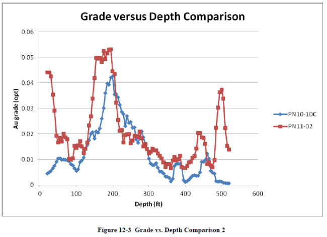
| December 19, 2011 | 48 | |
| Midway Gold Corp. | Mineral Processing and Metallurgical Testing |
| Pan Gold Project Feasibility Study | NI 43-101 Technical Report |
|
13
|
MINERAL PROCESSING AND METALLURGICAL TESTING
|
|
13.1
|
Ore Sampling and Test Wor
|
Extensive metallurgical testing has been undertaken on samples from the Pan Project. Ongoing metallurgical analysis of fresh core samples and trench samples collected in 2010 was initiated in December 2010 by MIDWAY, and is conducted by Resource Development Inc. (RDi). The primary objective of this analysis is to generate sufficient metallurgical data for use in Preliminary Feasibility and Feasibility Studies. Data from both previous work and from the ongoing test program indicate that the ore is amenable to heap leaching with economic recoveries. The analysis described in this section is limited to the ongoing test program, as previous test work was discussed in detail in the 2010 Preliminary Feasibility Study.
|
13.2
|
Ongoing Metallurgical Test work
|
RDi received three surface samples, designated NP 1, NP 2, and SP 1, and a ½ split of HQ (2.5-in diameter) drill core from thirteen drill holes. Seven of the drill holes are located in South Pan, and six are located in North Pan. A total of twenty nine composites were prepared from the drill hole samples. The composites were prepared to evaluate different lithologies, ore types, and feed grades. Composites 1 to 10 represent North Pan and composites 11 to 29 represent South Pan. The lithology associated with each composite sample is identified in Table 13-1.
Table 13-1 Lithology of Composite Samples
|
Lithology of Composite Samples
|
||
|
Pit
|
Lithology
|
Composites
|
|
North Pit
|
Sbs
|
1-8, 10, NP-1, NP-2
|
|
SbA
|
9
|
|
|
South Pit
|
ShA
|
11, 28, 29
|
|
ShS
|
12, 13
|
|
|
SbA
|
14-18, 22, 24-27, SP-1
|
|
|
SbA
|
19, 23
|
|
|
HbS
|
20
|
|
|
HbA
|
21
|
|
Detailed information regarding sample preparation protocols and quality control procedures is presented in a report prepared by RDi, “Midway Gold Corporation, Metallurgical Testing of Midway Pan Samples”, dated September 14, 2011. The following paragraphs summarize the metallurgical test results described in the text of that report.
| December 19, 2011 | 49 | |
| Midway Gold Corp. | Mineral Processing and Metallurgical Testing |
| Pan Gold Project Feasibility Study | NI 43-101 Technical Report |
|
13.2.1
|
Head Assays
|
The results of head analyses conducted on the composite samples are given in Table 13-2. The samples were submitted for gold and silver assay using one-assay-ton fire assay, mercury, and preg robbing analyses.
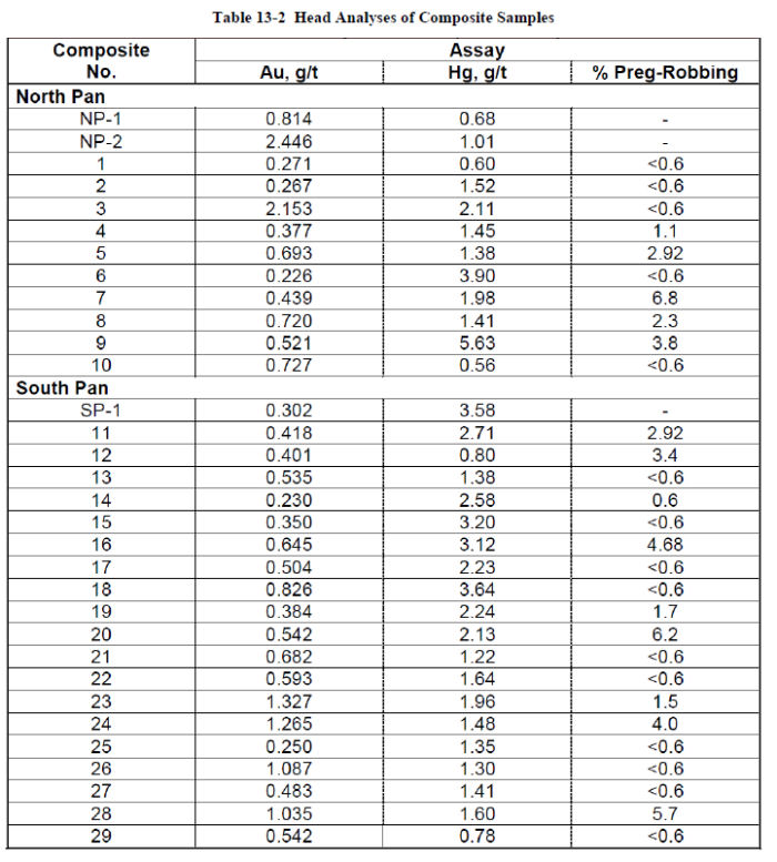
| December 19, 2011 | 50 | |
| Midway Gold Corp. | Mineral Processing and Metallurgical Testing |
| Pan Gold Project Feasibility Study | NI 43-101 Technical Report |
The head analyses indicate the following:
|
●
|
The gold assays range from 0.023 g/t Au to 2.15 g/t Au
|
|
●
|
The mercury values in these samples range from 0.56 to 5.63 g/t Hg
|
|
●
|
The majority of the composites exhibited negligible preg-robbing properties
|
13.2.2 XRF Analyses
X-ray fluorescence (XRF) analyses were conducted on selected samples representing the various composite lithologies, and on the surface samples. The XRF test results are presented in Table 13-3. Test results indicate that traces of arsenic were present in the samples, though the major elements present were silica and alumina.

| December 19, 2011 | 51 | |
| Midway Gold Corp. | Mineral Processing and Metallurgical Testing |
| Pan Gold Project Feasibility Study | NI 43-101 Technical Report |
|
13.2.3
|
XRD Analysis
|
X-ray diffraction (XRD) analyses provide an indication of major minerals in the samples. The samples analyzed by XRF were also analyzed by XRD. The results of the XRD analyses indicate that the major host rock minerals are quartz, mica/illite, and alunite. The XRD test results are summarized in Table 13-4.
Table 13-4 XRD Test Results
|
XRD Analysis of Different Rock Types
|
|||||||||
|
Element, ppm
|
Approximate Wt. %
|
||||||||
|
7
|
12
|
15
|
20
|
21
|
28
|
NP1
|
NP2
|
SP1
|
|
|
Quartz
|
85
|
74
|
63
|
83
|
79
|
66
|
85
|
70
|
63
|
|
Mica/illite
|
10
|
7
|
24
|
9
|
6
|
21
|
5
|
10
|
16
|
|
Kaolinite
|
-
|
8
|
<5
|
<5
|
<3
|
5
|
-
|
-
|
8
|
|
K-spar
|
-
|
-
|
-
|
-
|
-
|
3?
|
-
|
-
|
-
|
|
Alunite
|
<3
|
9
|
-
|
<5
|
10
|
-
|
8
|
14
|
9
|
|
Calcite
|
-
|
-
|
<5
|
-
|
10
|
-
|
-
|
<3
|
|
|
Hematite
|
<2?
|
<3
|
<3
|
<3
|
<3
|
-
|
-
|
<3
|
<3
|
|
Barite
|
-
|
-
|
-
|
-
|
-
|
<5
|
<3
|
-
|
|
|
Unidentified
|
<5
|
<5
|
<5
|
<5
|
<5
|
<5
|
<3
|
<5
|
<5
|
|
13.2.4
|
ICP Analysis
|
The results of ICP analysis of the composite samples are summarized in Table 13-5. The results of the ICP analyses are similar to the results of XRF analyses of the composite samples.
| December 19, 2011 | 52 | |
| Midway Gold Corp. | Mineral Processing and Metallurgical Testing |
| Pan Gold Project Feasibility Study | NI 43-101 Technical Report |
Table 13-5 ICP Analyses of Composite Samples
|
Element,
%
|
Composite No.
|
||||||||
|
1
|
2
|
3
|
4
|
5
|
6
|
7
|
8
|
9
|
|
|
Al
|
2.46
|
1.99
|
1.99
|
2.14
|
2.44
|
4.03
|
2.20
|
2.68
|
3.71
|
|
Ca
|
0.09
|
0.07
|
0.09
|
0.08
|
0.06
|
4.49
|
0.08
|
0.83
|
1.90
|
|
Fe
|
0.89
|
0.68
|
0.81
|
1.43
|
1.44
|
2.32
|
0.69
|
0.69
|
2.15
|
|
K
|
1.00
|
0.86
|
0.69
|
0.85
|
0.80
|
1.70
|
1.02
|
1.21
|
1.50
|
|
Mg
|
0.12
|
0.14
|
0.12
|
0.06
|
0.06
|
0.38
|
0.14
|
0.23
|
0.29
|
|
Na
|
0.03
|
0.05
|
0.05
|
0.03
|
0.06
|
0.04
|
0.03
|
0.08
|
0.04
|
|
Ti
|
0.08
|
0.03
|
0.06
|
0.06
|
0.03
|
0.09
|
0.05
|
0.05
|
0.10
|
|
Element, ppm
|
|||||||||
|
As
|
88
|
249
|
179
|
279
|
562
|
342
|
145
|
100
|
436
|
|
Ba
|
417
|
1995
|
1955
|
8020
|
858
|
5219
|
798
|
2344
|
7730
|
|
Bi
|
26
|
<10
|
<10
|
22
|
<10
|
36
|
18
|
20
|
41
|
|
Cd
|
3
|
0
|
1
|
9
|
2
|
14
|
4
|
4
|
13
|
|
Co
|
5
|
10
|
<1
|
9
|
6
|
33
|
17
|
9
|
10
|
|
Cr
|
39
|
31
|
117
|
28
|
33
|
49
|
31
|
35
|
52
|
|
Cu
|
69
|
16
|
20
|
43
|
16
|
52
|
41
|
63
|
53
|
|
Mn
|
13
|
17
|
13
|
13
|
35
|
260
|
18
|
40
|
146
|
|
Mo
|
2
|
4
|
5
|
9
|
8
|
8
|
10
|
2
|
8
|
|
Ni
|
14
|
18
|
23
|
15
|
22
|
152
|
20
|
25
|
61
|
|
Pb
|
78
|
52
|
39
|
185
|
29
|
146
|
64
|
82
|
101
|
|
Sr
|
116
|
81
|
107
|
196
|
168
|
164
|
84
|
137
|
254
|
|
105
|
81
|
106
|
60
|
81
|
107
|
84
|
62
|
85
|
|
|
W
|
44
|
168
|
<10
|
77
|
63
|
25
|
105
|
75
|
51
|
|
Zn
|
36
|
62
|
43
|
70
|
76
|
574
|
65
|
227
|
233
|
| December 19, 2011 | 53 | |
| Midway Gold Corp. | Mineral Processing and Metallurgical Testing |
| Pan Gold Project Feasibility Study | NI 43-101 Technical Report |
Table 13-5 cont.
|
Element,
%
|
Composite No.
|
||||||||||
|
10
|
11
|
12
|
13
|
14
|
15
|
16
|
17
|
18
|
19
|
20
|
|
|
Al
|
2.17
|
5.55
|
3.72
|
4.65
|
3.77
|
4.41
|
3.92
|
3.27
|
3.89
|
2.41
|
3.07
|
|
Ca
|
0.09
|
6.59
|
0.11
|
0.46
|
16.02
|
1.43
|
0.13
|
0.11
|
0.12
|
0.10
|
0.12
|
|
Fe
|
0.49
|
2.81
|
1.65
|
4.69
|
1.94
|
2.28
|
1.92
|
1.67
|
1.85
|
1.80
|
1.58
|
|
K
|
0.70
|
2.33
|
1.30
|
1.27
|
1.60
|
2.16
|
1.25
|
1.17
|
1.51
|
0.97
|
1.16
|
|
Mg
|
0.15
|
0.79
|
0.13
|
0.22
|
0.32
|
0.31
|
0.11
|
0.12
|
0.15
|
0.14
|
0.13
|
|
Na
|
0.05
|
0.07
|
0.13
|
0.10
|
0.09
|
0.07
|
0.13
|
0.06
|
0.04
|
0.05
|
0.03
|
|
Ti
|
0.09
|
0.07
|
0.08
|
0.14
|
0.09
|
0.11
|
0.04
|
0.08
|
0.10
|
0.06
|
0.07
|
|
Element, ppm
|
|||||||||||
|
As
|
39
|
3120
|
350
|
1120
|
451
|
851
|
2360
|
1012
|
1063
|
464
|
302
|
|
Ba
|
295
|
426
|
216
|
273
|
430
|
952
|
332
|
378
|
617
|
1056
|
328
|
|
Bi
|
<10
|
27
|
31
|
11
|
32
|
41
|
<10
|
27
|
29
|
21
|
26
|
|
Cd
|
1
|
6
|
10
|
6
|
12
|
25
|
2
|
27
|
30
|
12
|
8
|
|
Co
|
2
|
36
|
3
|
5
|
5
|
11
|
3
|
4
|
4
|
5
|
2
|
|
Cr
|
92
|
59
|
57
|
95
|
43
|
65
|
43
|
52
|
52
|
41
|
52
|
|
Cu
|
20
|
31
|
37
|
34
|
19
|
27
|
11
|
22
|
41
|
24
|
42
|
|
Mn
|
4
|
1226
|
30
|
73
|
585
|
334
|
15
|
16
|
10
|
18
|
8
|
|
Mo
|
2
|
21
|
20
|
24
|
7
|
9
|
9
|
6
|
9
|
2
|
4
|
|
Ni
|
19
|
148
|
33
|
57
|
52
|
83
|
23
|
31
|
33
|
26
|
14
|
|
Pb
|
28
|
29
|
81
|
34
|
38
|
77
|
24
|
49
|
52
|
30
|
53
|
|
Sr
|
111
|
127
|
194
|
160
|
263
|
270
|
174
|
191
|
211
|
190
|
200
|
|
V
|
92
|
60
|
211
|
331
|
73
|
100
|
95
|
226
|
171
|
191
|
141
|
|
W
|
12
|
18
|
19
|
<10
|
6
|
11
|
28
|
22
|
26
|
37
|
20
|
|
Zn
|
33
|
199
|
92
|
84
|
154
|
351
|
77
|
69
|
108
|
121
|
117
|
| December 19, 2011 | 54 | |
| Midway Gold Corp. | Mineral Processing and Metallurgical Testing |
| Pan Gold Project Feasibility Study | NI 43-101 Technical Report |
Table 13-5 cont.
|
Element,
%
|
Composite No.
|
||||||||
|
21
|
22
|
23
|
24
|
25
|
26
|
27
|
28
|
29
|
|
|
Al
|
3.24
|
2.88
|
2.86
|
1.92
|
3.16
|
1.27
|
2.38
|
4.25
|
3.87
|
|
Ca
|
0.16
|
25.32
|
15.22
|
24.20
|
19.68
|
8.30
|
21.13
|
1.56
|
0.11
|
|
Fe
|
2.07
|
1.47
|
1.31
|
1.08
|
2.01
|
0.63
|
1.31
|
2.02
|
2.19
|
|
K
|
1.45
|
1.18
|
1.15
|
1.03
|
1.54
|
0.63
|
1.26
|
1.86
|
1.42
|
|
Mg
|
0.10
|
0.31
|
0.38
|
0.34
|
1.97
|
0.23
|
1.87
|
0.38
|
0.38
|
|
Na
|
0.02
|
0.05
|
0.05
|
0.05
|
0.02
|
0.01
|
0.05
|
0.07
|
0.06
|
|
Ti
|
0.09
|
0.09
|
0.09
|
0.06
|
0.09
|
0.04
|
0.06
|
0.11
|
0.05
|
|
Element, ppm
|
|||||||||
|
As
|
428
|
752
|
219
|
791
|
527
|
59
|
264
|
458
|
1165
|
|
Ba
|
2186
|
5600
|
10234
|
6487
|
18218
|
21697
|
4873
|
286
|
556
|
|
Bi
|
26
|
28
|
<10
|
22
|
34
|
16
|
22
|
34
|
21
|
|
Cd
|
14
|
21
|
2
|
22
|
18
|
7
|
9
|
14
|
3
|
|
Co
|
3
|
7
|
<1
|
4
|
16
|
8
|
6
|
9
|
6
|
|
Cr
|
58
|
34
|
78
|
28
|
36
|
16
|
31
|
49
|
45
|
|
Cu
|
40
|
19
|
19
|
21
|
77
|
82
|
15
|
31
|
21
|
|
Mn
|
8
|
2666
|
1183
|
1786
|
638
|
492
|
2418
|
311
|
89
|
|
Mo
|
2
|
10
|
4
|
12
|
9
|
5
|
4
|
17
|
19
|
|
Ni
|
20
|
32
|
24
|
20
|
44
|
12
|
23
|
68
|
76
|
|
Pb
|
34
|
35
|
37
|
26
|
36
|
44
|
29
|
31
|
40
|
|
Sr
|
145
|
163
|
88
|
124
|
200
|
76
|
146
|
178
|
97
|
|
V
|
138
|
39
|
11
|
27
|
39
|
30
|
35
|
173
|
211
|
|
W
|
31
|
7
|
<10
|
7
|
10
|
63
|
8
|
9
|
25
|
|
Zn
|
110
|
235
|
198
|
212
|
140
|
161
|
262
|
183
|
195
|
|
13.2.5
|
Crushability Work and Abrasion Index
|
Crusher work index and abrasion index tests were performed on six samples, each representing a different lithology. The test results, summarized in Table 13-6, indicate that the surface samples were relatively hard and abrasive whereas the drill core samples were softer and non-abrasive.
| December 19, 2011 | 55 | |
| Midway Gold Corp. | Mineral Processing and Metallurgical Testing |
| Pan Gold Project Feasibility Study | NI 43-101 Technical Report |
Table 13-6 Crushability and Abrasion Test Results
|
Crushability Work Index and Abrasion Index
for Composite Samples
|
|||
|
Sample
|
Lithology
|
Crushability Wi (Kw-hr/st)
|
Ai
|
|
Composite 7
|
SbS
|
6.15
|
0.0450
|
|
Composite 12
|
ShS
|
6.02
|
0.0086
|
|
Composite 15
|
SbA
|
4.92
|
0.0052
|
|
Composite 20
|
HbS
|
3.23
|
0.0022
|
|
Composite 21
|
HbA
|
7.46
|
0.0405
|
|
Composite 28
|
ShA
|
8.91
|
0.0107
|
|
NP-1
|
SbS
|
16.94
|
0.2820
|
|
NP-2
|
SbS
|
8.22
|
0.0780
|
|
SP-1
|
SbA
|
12.44
|
0.0236
|
|
13.2.6
|
Static Bucket Leach Tests for Surface Samples
|
The as-received surface samples were screened into six size fractions, and the individual fractions of equal size were combined in order to obtain a sufficient amount of each. The size fractions were placed into a plastic container and covered with a 1 g/L NaCN solution. The material was gently mixed and allowed to stand. A sample of the slurry was taken for pH and free cyanide measurement and gold assay. The pH of solution was adjusted to 11 and NaCN concentration to 1 g/L. Following the completion of the test, the solids were filtered, washed, and dried. The dried material was pulverized and assayed for gold.
Static bucket leach test results are summarized in Table 13-7. The test results indicate the following:
|
●
|
Gold extraction from the coarsest to the finest size fractions was good for the SP-1 sample; gold recovery is not size dependent for the South Pan samples.
|
|
●
|
The gold leaches very quickly, even from the coarse size fractions for the South Pan samples.
|
|
●
|
Gold extractions for the two North Pan samples were size dependent; the finer the crush size, the higher the gold extraction.
|
|
●
|
The gold extraction was acceptable once the North Pan samples were crushed to 0.5-inch or finer.
|
| December 19, 2011 | 56 | |
| Midway Gold Corp. | Mineral Processing and Metallurgical Testing |
| Pan Gold Project Feasibility Study | NI 43-101 Technical Report |
Table 13-7 Static Bucket Leach Test Results
|
Static Bucket Leach Tests (21-day duration)
|
|||||||||
|
Size (inches)
|
Sample SP-1
|
Sample NP-1
|
Sample NP-2
|
||||||
|
Extraction % Au
|
Residue g/t Au
|
Cal. Feed g/t Au
|
Extraction % Au
|
Residue g/t Au
|
Cal Feed g/t Au
|
Extraction % Au
|
Residue g/t Au
|
Cal. Feed g/t Au
|
|
|
3x4
|
93.7
|
0.189
|
3.013
|
51
|
0.399
|
0.815
|
52.4
|
0.547
|
1.15
|
|
2x3
|
76.7
|
0.034
|
0.146
|
58.3
|
0.394
|
0.946
|
59.2
|
0.879
|
2.169
|
|
1.5x2
|
86.4
|
0.046
|
0.339
|
53.3
|
0.42
|
0.899
|
64.2
|
0.437
|
1.22
|
|
1x1.5
|
84
|
0.069
|
0.432
|
65.1
|
0.153
|
0.438
|
59.3
|
0.674
|
1.656
|
|
0.5x1
|
86.2
|
0.086
|
0.622
|
64.2
|
0.149
|
0.416
|
84
|
0.233
|
1.453
|
|
-0.5
|
85.6
|
0.154
|
1.072
|
70.6
|
0.18
|
0.612
|
79.2
|
0.381
|
1.832
|
|
13.2.7
|
Bottle Roll Leach Tests
|
Cyanide bottle roll leach tests were performed on each composite sample at P80 6-mesh and 200-mesh. The test results are summarized in Tables 13-8 and 13-9. The test results show that gold extraction from the North Pan samples was poor for most composites (28% to 65%) at 6-mesh, but improved significantly (to over 75%) at P80 200-mesh. This suggests that gold extraction is size dependent at North Pan. Gold extraction from the South Pan samples was over 70% at 6-mesh and over 80% at 200-mesh. The NaCN consumptions were reasonable for all the bottle roll leach tests.
| December 19, 2011 | 57 | |
| Midway Gold Corp. | Mineral Processing and Metallurgical Testing |
| Pan Gold Project Feasibility Study | NI 43-101 Technical Report |
Table 13-8 Bottle Roll Cyanidation Test Results – Composite Sample, 6-mesh
|
Bottle Roll Cyanidation Test Results for Composite Samples at 6-mesh
|
||||||
|
Test No.
|
Composite No.
|
Extraction % Au
|
Residue g/t Au
|
Cal. Head
|
Reagent Consumption, kg/t
|
|
|
NaCN
|
Lime
|
|||||
|
BR-1
|
NP-1
|
82.9
|
0.12
|
0.68
|
0.176
|
2.542
|
|
BR-2
|
NP-2
|
85.3
|
0.38
|
2.56
|
0.173
|
6.094
|
|
27
|
1
|
71.9
|
0.09
|
0.306
|
0.056
|
2.607
|
|
7
|
2
|
48.7
|
0.12
|
0.23
|
0.301
|
2.723
|
|
39
|
3
|
28.7
|
1.41
|
1.971
|
0.121
|
2.549
|
|
28
|
4
|
65.3
|
0.15
|
0.436
|
0.054
|
2.008
|
|
8
|
5
|
52.3
|
0.43
|
0.89
|
0.12
|
1.749
|
|
29
|
6
|
74.4
|
0.1
|
0.386
|
Trace
|
3.597
|
|
49
|
7
|
33.7
|
0.34
|
0.51
|
0.12
|
2.688
|
|
17
|
8
|
34.4
|
0.45
|
0.69
|
0.113
|
2.942
|
|
50
|
9
|
85.2
|
0.11
|
0.728
|
0.233
|
2.978
|
|
40
|
10
|
60.5
|
0.32
|
0.802
|
0.058
|
2.489
|
|
BR-3
|
SP-1
|
89.5
|
0.06
|
0.6
|
0.288
|
3.523
|
|
9
|
11
|
58.2
|
0.17
|
0.41
|
0.109
|
4.335
|
|
18
|
12
|
72.8
|
0.14
|
0.5
|
0.297
|
2.995
|
|
41
|
13
|
91.9
|
0.07
|
0.863
|
0.112
|
6.922
|
|
19
|
14
|
78.1
|
0.06
|
0.26
|
0.355
|
2.926
|
|
20
|
15
|
82.5
|
0.06
|
0.33
|
0.109
|
4.424
|
|
10
|
16
|
65.4
|
0.23
|
0.67
|
0.239
|
2.581
|
|
21
|
17
|
72.2
|
0.16
|
0.57
|
0.171
|
3.067
|
|
30
|
18
|
73.4
|
0.32
|
1.209
|
0.176
|
2.91
|
|
22
|
19
|
59.5
|
0.18
|
0.45
|
0.11
|
2.644
|
|
51
|
20
|
81.3
|
0.09
|
0.503
|
0.229
|
3.363
|
|
52
|
21
|
76.8
|
0.18
|
0.768
|
0.16
|
2.533
|
|
23
|
22
|
76.5
|
0.14
|
0.6
|
0.248
|
2.755
|
|
42
|
23
|
63.1
|
0.53
|
1.422
|
Trace
|
1.905
|
|
24
|
24
|
70.2
|
0.39
|
1.31
|
0.292
|
2.423
|
|
31
|
25
|
77.5
|
0.08
|
0.351
|
0.103
|
2.404
|
|
32
|
26
|
45.4
|
0.66
|
1.209
|
Trace
|
1.917
|
|
25
|
27
|
81.9
|
0.1
|
0.54
|
0.418
|
2.745
|
|
26
|
28
|
93
|
0.09
|
1.25
|
0.231
|
4.645
|
|
11
|
29
|
68.5
|
0.15
|
0.46
|
0.296
|
3.63
|
|
Average North Pan
|
60.3
|
0.34
|
0.85
|
0.127
|
2.91
|
|
|
Average South Pan
|
73.9
|
0.19
|
0.71
|
0.189
|
3.23
|
|
| December 19, 2011 | 58 | |
| Midway Gold Corp. | Mineral Processing and Metallurgical Testing |
| Pan Gold Project Feasibility Study | NI 43-101 Technical Report |
Table 13-9 Bottle Roll Cyanidation Test Results – Composite Sample, 200-mesh
|
Bottle Roll Cyanidation Test Results for Composite Samples at 200-mesh
|
||||||
|
Test No.
|
Composite No.
|
Extraction % Au
|
Residue g/t Au
|
Cal. Head
|
Reagent Consumption, kg/t
|
|
|
NaCN
|
Lime
|
|||||
|
BR-4
|
NP-1
|
90.8
|
0.07
|
0.72
|
1.309
|
3.31
|
|
BR-5
|
NP-2
|
88.6
|
0.28
|
2.41
|
0.465
|
5.501
|
|
33
|
1
|
85.4
|
0.09
|
0.594
|
0.115
|
5.881
|
|
12
|
2
|
79.8
|
0.06
|
0.29
|
0.159
|
5.248
|
|
43
|
3
|
75.2
|
0.56
|
2.235
|
1.279
|
7.983
|
|
34
|
4
|
87.4
|
0.07
|
0.556
|
0.125
|
4.656
|
|
13
|
5
|
82.6
|
0.15
|
0.89
|
0.125
|
4.641
|
|
35
|
6
|
87.5
|
0.07
|
0.591
|
0.597
|
3.571
|
|
36
|
7
|
75.6
|
0.17
|
0.687
|
0.116
|
5.031
|
|
45
|
8
|
81.5
|
0.16
|
0.879
|
0.34
|
6.622
|
|
37
|
9
|
89.1
|
0.07
|
0.643
|
0.112
|
4.107
|
|
48
|
10
|
77.2
|
0.16
|
0.697
|
1.125
|
7.055
|
|
BR-6
|
SP-1
|
89.7
|
0.05
|
0.49
|
0.153
|
6.119
|
|
14
|
11
|
71.9
|
0.12
|
0.42
|
0.111
|
7.087
|
|
44
|
12
|
83.2
|
0.11
|
0.63
|
0.221
|
6.17
|
|
53
|
13
|
87.3
|
0.08
|
0.624
|
0.222
|
3.057
|
|
54
|
14
|
81.8
|
0.04
|
0.217
|
0.227
|
3.009
|
|
55
|
15
|
80.6
|
0.07
|
0.362
|
0.157
|
4.621
|
|
15
|
16
|
92.9
|
0.05
|
0.65
|
0.229
|
5.55
|
|
56
|
17
|
80.8
|
0.12
|
0.608
|
0.168
|
3.885
|
|
38
|
18
|
87.8
|
0.17
|
1.396
|
0.108
|
5.314
|
|
57
|
19
|
79.1
|
0.1
|
0.484
|
0.282
|
3.508
|
|
58
|
20
|
86.8
|
0.07
|
0.559
|
0.28
|
1.586
|
|
59
|
21
|
87.8
|
0.14
|
1.151
|
0.104
|
2.907
|
|
60
|
22
|
84.2
|
0.09
|
0.577
|
0.097
|
3.248
|
|
61
|
23
|
82.4
|
0.25
|
1.42
|
0.098
|
2.757
|
|
62
|
24
|
81.8
|
0.23
|
1.269
|
0.046
|
2.798
|
|
46
|
25
|
83.6
|
0.06
|
0.347
|
0.15
|
6.912
|
|
47
|
26
|
82.3
|
0.2
|
1.153
|
0.11
|
5.823
|
|
63
|
27
|
86.7
|
0.07
|
0.504
|
0.095
|
3.225
|
|
64
|
28
|
88
|
0.16
|
1.311
|
0.088
|
4.248
|
|
16
|
29
|
63.2
|
0.18
|
0.48
|
0.102
|
6.151
|
|
Average North Pan
|
83.4
|
0.16
|
0.93
|
0.489
|
5.3
|
|
|
Average South Pan
|
83.1
|
0.12
|
0.73
|
0.152
|
4.4
|
|
| December 19, 2011 | 59 | |
| Midway Gold Corp. | Mineral Processing and Metallurgical Testing |
| Pan Gold Project Feasibility Study | NI 43-101 Technical Report |
After 72 hours of leach, the average gold extraction from the bottle roll leach tests at P80 6-mesh was 60.3% for North Pan samples and 73.9% for South Pan samples. Sodium cyanide consumption averaged 0.127 kg/t for the North Pan samples and 0.189 kg/t for the South Pan samples. The average head grades for the North and South Pan samples are 0.85 g/t and 0.71 g/t, respectively.
The average extractions at P80 200-mesh were almost identical for the North and South Pan samples (83.4% and 83.1%) for 72 hours of leach time. The cyanide and lime consumption at finer grind was much higher for North Pan samples than for South Pan samples.
|
13.2.8
|
Column Leach Tests
|
A total of 40 open-circuit column leach tests were performed on the three surface samples and twenty nine composite drill core samples. There are 16 additional column leach tests still underway, the majority of these on North Pan samples at a finer crush size. At least two column tests are run on each composite, and all columns at RDi are run in standard plexiglas columns of variable diameter. The feeds of P80 ½-inch, 1-inch, and 1½--inch are processed in 4-inch, 6-inch, and 8-inch diameter columns, respectively.
|
13.2.8.1
|
Assay-by-Size Fraction for Gold
|
Assay-by-size for gold was determined for the composite feed sample used for running the columns at P80 1½-inch crush size. Data from select composites is summarized in Table 13-10. The data indicate that the distribution of gold is generally proportional to weight for the North Pan samples, and that the gold tends to distribute preferentially in the finer sizes for the South Pan samples.
| December 19, 2011 | 60 | |
| Midway Gold Corp. | Mineral Processing and Metallurgical Testing |
| Pan Gold Project Feasibility Study | NI 43-101 Technical Report |
Table 13-10 Assay-by-Size Fraction Data
|
Assay-by-Size Fraction for Gold in Composite Samples
|
||||||||||||
|
Size Fraction (inches)
|
NP-1
|
SP-1
|
Composite No. 1
|
Composite No. 10
|
||||||||
|
Assay g/t Au
|
Distribution %
|
Assay g/t Au
|
Distribution %
|
Assay g/t Au
|
Distribution %
|
Assay g/t Au
|
Distribution %
|
|||||
|
Wt.
|
Au
|
Wt.
|
Au
|
Wt.
|
Au
|
Wt.
|
Au
|
|||||
|
+1.5
|
1.00
|
16.8
|
30.7
|
0.16
|
17.1
|
6.9
|
1.94
|
10.4
|
15
|
0.9
|
5.8
|
4.3
|
|
1x7.5
|
0.49
|
30.5
|
27.3
|
0.15
|
16.5
|
6.2
|
1.02
|
26.2
|
19.6
|
0.66
|
31.2
|
17.1
|
|
0.75x1
|
0.38
|
16.3
|
11.4
|
0.18
|
10.5
|
4.8
|
1.3
|
19
|
18.1
|
0.69
|
14.9
|
8.5
|
|
0.5x0.75
|
0.45
|
11.6
|
9.5
|
0.18
|
7.2
|
3.2
|
1.32
|
20.6
|
20
|
0.82
|
17.2
|
11.6
|
|
-0.5
|
0.47
|
24.8
|
21.1
|
0.64
|
48.7
|
78.9
|
1.56
|
23.8
|
27.3
|
2.29
|
30.9
|
58.5
|
|
Cal. Feed
|
0.55
|
0.39
|
1.36
|
1.21
|
||||||||
|
Assay-by-Size Fraction for Gold in Composite Samples
|
||||||||||||
|
Size Fraction (inches)
|
13
|
16
|
19
|
24
|
||||||||
|
Assay g/t Au
|
Distribution %
|
Assay g/t Au
|
Distribution %
|
Assay g/t Au
|
Distribution %
|
Assay g/t Au
|
Distribution %
|
|||||
|
Wt.
|
Au
|
Wt.
|
Au
|
Wt.
|
Au
|
Wt.
|
Au
|
|||||
|
+1.5
|
0.34
|
14.7
|
9.4
|
1.45
|
31.9
|
41.8
|
0.31
|
36.9
|
31.8
|
0.79
|
34
|
27.8
|
|
1x7.5
|
0.52
|
20.4
|
19.8
|
0.8
|
36.8
|
26.3
|
0.24
|
20.8
|
13.9
|
1.1
|
20.5
|
23.3
|
|
0.75x1
|
0.49
|
13
|
12
|
0.53
|
13.1
|
6.2
|
0.14
|
8.7
|
3.3
|
1.06
|
10.6
|
11.7
|
|
0.5x0.75
|
0.33
|
14.5
|
9
|
1.19
|
7.3
|
7.9
|
0.45
|
9.1
|
11.3
|
1.13
|
8.8
|
10.3
|
|
-0.5
|
0.71
|
37.5
|
49.8
|
1.83
|
10.8
|
17.8
|
0.58
|
24.5
|
39.8
|
0.99
|
26.1
|
26.9
|
|
Cal. Feed
|
0.54
|
1.11
|
0.36
|
0.96
|
||||||||
| December 19, 2011 | 61 | |
| Midway Gold Corp. | Mineral Processing and Metallurgical Testing |
| Pan Gold Project Feasibility Study | NI 43-101 Technical Report |
|
13.2.8.1
|
Test Results
|
Column leach test results for the North and South Pan samples are presented in Tables 13-11 and 13-12, respectively. The test data for all samples (including KCA samples) is averaged for each crush size (0.5, 1.0, and 1.5-inch) and for all columns. Test results indicate the following:
Gold extraction for North Pan samples was 63.6% in 75 days of leach time at P80 ½-inch, 78.5% in 61 days at P80 1-inch, and 60.8% in 86 days of leach time at P80 1½-inch crush size.
The gold extraction for all North Pan samples was 63.1% in 79 days of leach time. The NaCN consumption averaged 0.691 kg/t.
Gold extraction for South Pan samples was 85.6% in 54 days of leach time at P80 ½-inch crush size, 80.3% in 64 days of leach time at P80 1-inch crush size, and 86.2% in 60 days of leach time at P80 1½-inch crush size.
The gold extraction for all South Pan samples was 84.6% in 60 days of leach time. The NaCN consumption averaged 0.692 kg/t.
Table 13-11 Summary of Column Leach Test Results for North Pan Samples
| Summary of Column Leach Test Results for North Pan Samples | ||||||
| Composite No. |
Crush
Size P80
ins
|
Leach Time
Days
|
Extraction
% Au |
Residue
g/t Au |
Cal. Head
g/t Au
|
NaCN
Consumption
Kg/t
|
|
NP-1
|
1.5
|
41
|
52.4
|
0.309
|
0.649
|
0.154
|
|
NP-1
|
0.5
|
41
|
73.4
|
0.182
|
0.637
|
0.637
|
|
NP-2
|
0.5
|
41
|
73.1
|
0.394
|
1.462
|
0.873
|
|
NP-2
|
1.5
|
41
|
46.1
|
0.792
|
1.470
|
0.196
|
|
2
|
0.5
|
31
|
53.0
|
0.141
|
0.300
|
0.458
|
|
3
|
1.5
|
62
|
35.4
|
0.874
|
1.353
|
0.476
|
|
5
|
0.5
|
31
|
48.4
|
0.471
|
0.913
|
0.528
|
|
8
|
0.5
|
90
|
39.5
|
0.393
|
0.649
|
2.219
|
|
9
|
1.0
|
61
|
78.5
|
0.063
|
0.587
|
0.432
|
|
10
|
1.5
|
108
|
84.7
|
0.225
|
1.474
|
1.245
|
|
KCA32480
|
0.5
|
110
|
73.0
|
0.218
|
0.746
|
0.990
|
|
KCA32480
|
1.5
|
112
|
71.0
|
0.218
|
0.809
|
0.415
|
|
KCA32481
|
0.5
|
110
|
78.0
|
0.467
|
2.084
|
1.480
|
|
KCA32481
|
1.5
|
112
|
73.0
|
0.559
|
2.115
|
0.575
|
|
KCA32482
|
0.5
|
74
|
85.0
|
0.124
|
0.809
|
1.270
|
|
KCA32482
|
1.5
|
77
|
85.0
|
0.124
|
0.840
|
0.360
|
|
KCA32483
|
0.5
|
110
|
58.0
|
0.467
|
1.120
|
0.875
|
|
KCA32483
|
1.5
|
112
|
54.0
|
0.498
|
1.089
|
0.430
|
|
KCA32484
|
0.5
|
110
|
55.0
|
0.404
|
1.151
|
0.985
|
|
KCA32484
|
1.5
|
112
|
46.0
|
0.467
|
1.151
|
0.430
|
|
Average
|
0.5
|
75
|
63.6
|
0.362
|
0.987
|
0.810
|
|
Average
|
1.0
|
61
|
78.5
|
0.063
|
0.587
|
0.432
|
|
Average
|
1.5
|
86
|
60.8
|
0.452
|
1.216
|
0.476
|
|
Average
|
All
|
79
|
63.1
|
0.370
|
1.070
|
0.641
|
| December 19, 2011 | 62 | |
| Midway Gold Corp. | Mineral Processing and Metallurgical Testing |
| Pan Gold Project Feasibility Study | NI 43-101 Technical Report |
Table 13-12 Summary of Column Leach Test Results for South Pan Samples
| Summary of Column Leach Test Results for South Pan Samples | ||||||
|
Composite
No.
|
Crush
Size P80
ins
|
Leach
Time
Days
|
Extraction
% Au
|
Residue
g/t Au
|
Cal. head
g/t Au
|
NaCN Consumption
Kg/t
|
|
SP-1
|
0.5
|
41
|
95.7
|
0.015
|
0.352
|
0.628
|
|
11
|
0.5
|
31
|
74.3
|
0.125
|
0.487
|
0.509
|
|
11
|
1.0
|
66
|
77.8
|
0.204
|
0.918
|
0.729
|
|
12
|
0.5
|
62
|
86.5
|
0.069
|
0.513
|
1.058
|
|
13
|
1.5
|
62
|
95.5
|
0.039
|
0.860
|
0.416
|
|
14
|
0.5
|
62
|
91.2
|
0.024
|
0.274
|
1.058
|
|
14
|
1.5
|
60
|
91.3
|
0.031
|
0.356
|
0.444
|
|
15
|
0.5
|
62
|
85.2
|
0.026
|
0.352
|
0.764
|
|
15
|
1.5
|
60
|
95.2
|
0.026
|
0.537
|
0.454
|
|
16
|
0.5
|
31
|
85.0
|
0.098
|
0.655
|
0.493
|
|
16
|
1.0
|
68
|
83.8
|
0.158
|
0.945
|
0.878
|
|
16
|
1.5
|
60
|
90.8
|
0.091
|
0.994
|
0.674
|
|
17
|
0.5
|
62
|
86.3
|
0.072
|
0.526
|
0.880
|
|
17
|
1.5
|
69
|
79.2
|
0.082
|
0.395
|
0.641
|
|
18
|
1.0
|
61
|
87.5
|
0.120
|
0.961
|
0.437
|
|
18
|
0.5
|
68
|
75.1
|
0.192
|
0.772
|
1.378
|
|
19
|
0.5
|
60
|
92.8
|
0.034
|
0.471
|
0.853
|
|
19
|
1.5
|
69
|
92.4
|
0.043
|
0.568
|
0.467
|
|
20
|
1.0
|
61
|
54.2
|
0.398
|
0.870
|
0.790
|
|
21
|
1.0
|
61
|
85.8
|
0.098
|
0.688
|
0.574
|
|
22
|
0.5
|
60
|
75.8
|
0.149
|
0.616
|
0.974
|
|
23
|
1.5
|
62
|
76.1
|
0.370
|
1.551
|
0.445
|
|
24
|
0.5
|
62
|
83.2
|
0.171
|
1.015
|
0.695
|
|
25
|
1
|
66
|
78.7
|
0.110
|
0.517
|
0.764
|
|
25
|
1.5
|
69
|
76.8
|
0.177
|
0.764
|
0.503
|
|
26
|
1
|
66
|
94.7
|
0.031
|
0.588
|
0.705
|
|
27
|
0.5
|
62
|
94.5
|
0.031
|
0.565
|
0.651
|
|
27
|
1.5
|
69
|
78.4
|
0.209
|
0.967
|
0.502
|
|
28
|
0.5
|
62
|
98.7
|
0.022
|
1.752
|
0.849
|
|
29
|
0.5
|
31
|
74.1
|
0.117
|
0.451
|
0.547
|
|
Average
|
0.5
|
54
|
85.6
|
0.082
|
0.629
|
0.81
|
|
Average
|
1
|
64
|
80.3
|
0.16
|
0.783
|
0.697
|
|
Average
|
1.5
|
64
|
86.2
|
0.119
|
0.777
|
0.505
|
|
Average
|
All
|
60
|
84.6
|
0.111
|
0.709
|
0.692
|
| December 19, 2011 | 63 | |
| Midway Gold Corp. | Mineral Processing and Metallurgical Testing |
| Pan Gold Project Feasibility Study | NI 43-101 Technical Report |
|
13.2.8.3
|
Percent Slump
|
The height of ore in the column tests was measured before and after leaching. None of the columns showed much slump, indicating low probability of permeability problems in production heaps.
|
13.2.8.4
|
Drain Down and Maximum Percolation Rate
|
At the conclusion of leaching, all columns were allowed to drain as completely as possible. The columns were then rinsed for several days and monitored for free cyanide. When free cyanide could no longer be detected, the rinse was shut down and the columns were allowed to drain.
Percolation tests were conducted on the columns after leaching was completed. Each column was flooded to a level approximately 2 inches above the surface of the material, and the water flow rate adjusted to maintain that level. The amount of solution exiting the bottom of the column was measured to determine the flow rate following stabilization of the water level. Percolation test results are reported in Table 13-13.
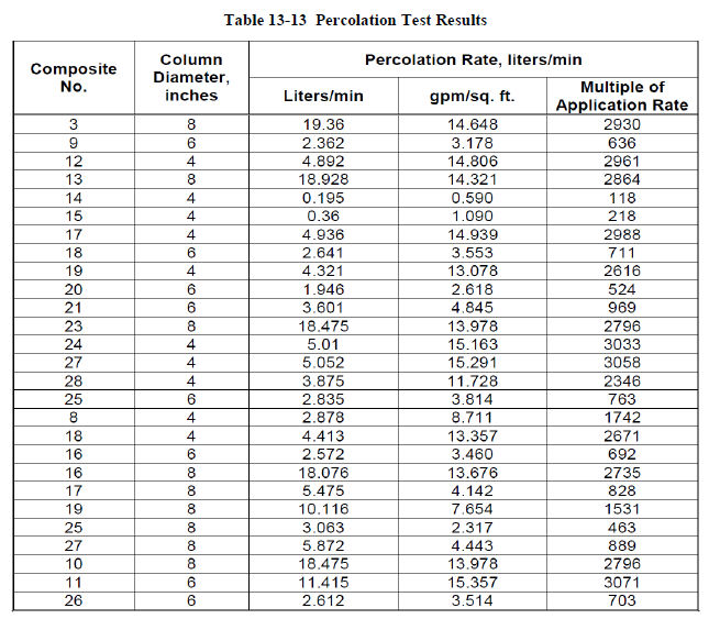
| December 19, 2011 | 64 | |
| Midway Gold Corp. | Mineral Processing and Metallurgical Testing |
| Pan Gold Project Feasibility Study | NI 43-101 Technical Report |
|
13.2.8.5
|
Tailing Analysis
|
After completion of the percolation tests, the columns were allowed to drain for a period of 48 hours before being dumped and prepared for tailings analysis. A sample of air dried, crushed and split leached residue was wet- and dry- screened and assayed for gold by size fraction. Test results of the residue assay-by-size are summarized in Table 13-14.
Table 13-14 Residue Assay-by-Size Data
|
Distribution of Gold in Leach Residues by Size
|
|||||||||
|
Size Fraction (inches)
|
Composite 10
|
Composite 24
|
Composite 27
|
||||||
|
Assay g/t Au
|
Distribution %
|
Assay g/t Au
|
Distribution %
|
Assay g/t Au
|
Distribution %
|
||||
|
Wt.
|
Au
|
Wt.
|
Au
|
Wt.
|
Au
|
||||
|
+1.5
|
0.11
|
16.0
|
11.6
|
0.04
|
18.4
|
11.6
|
0.13
|
24.9
|
18.7
|
|
1x1.5
|
0.15
|
42.0
|
42.7
|
0.07
|
35.5
|
42.6
|
0.17
|
22.6
|
21.7
|
|
0.75x1
|
0.14
|
16.2
|
14.9
|
0.05
|
12.3
|
10.6
|
0.12
|
3.7
|
2.4
|
|
0.5x0.75
|
0,15
|
13.3
|
13.4
|
0.08
|
8.8
|
10.7
|
0.10
|
5.8
|
3.2
|
|
-0.5
|
0.21
|
12.5
|
17.4
|
0.06
|
25.0
|
24.4
|
0.22
|
43.0
|
54.0
|
|
Cal. Feed
|
0.15
|
0.06
|
0.17
|
||||||
|
13.2.8.6
|
Pregnant Solution Analysis
|
The pregnant solution from the leach column tests was analyzed during leaching to determine the quality of the solution. The results of the solution analysis are summarized in Table 13-15 A and B. Test results indicate that no problem-creating components were present in the pregnant solution during carbon loading.
| December 19, 2011 | 65 | |
| Midway Gold Corp. | Mineral Processing and Metallurgical Testing |
| Pan Gold Project Feasibility Study | NI 43-101 Technical Report |
Table 13-15 A and B, Pregnant Solution Analyses
|
Pregnant Solution Analyses for Surface Samples
|
||||||
|
Element
ppm |
Column No.
|
|||||
|
NP-1
|
NP-2
|
SP-1
|
||||
|
Days 2-6
|
Days 14-23
|
Days 2-6
|
Days 14-23
|
Days 2-6
|
Days 14-23
|
|
|
Au
|
0.27
|
0.05
|
0.7
|
0.09
|
0.43
|
0.01
|
|
Al
|
0.05
|
0.1
|
0.6
|
<0.1
|
0.2
|
<0.1
|
|
As
|
0.02
|
<0.1
|
0.5
|
0.8
|
0.1
|
0.5
|
|
Ba
|
0.4
|
<0.1
|
<0.1
|
<0.1
|
0.1
|
<0.1
|
|
Bi
|
<0.1
|
<0.1
|
0.6
|
<0.1
|
<0.1
|
<0.1
|
|
Ca
|
47
|
1.5
|
5
|
1.7
|
134
|
4
|
|
Cd
|
<0.1
|
<0.1
|
<0.1
|
<0.1
|
<0.1
|
<0.1
|
|
Co
|
<0.1
|
<0.1
|
<0.1
|
<0.1
|
<0.1
|
<0.1
|
|
Cr
|
0.1
|
<0.1
|
0.1
|
<0.1
|
0.2
|
<0.1
|
|
Cu
|
1.7
|
0.3
|
1.7
|
0.3
|
3.3
|
0.3
|
|
Fe
|
<0.1
|
<0.1
|
<0.1
|
0.1
|
<0.1
|
<0.1
|
|
K
|
14
|
3.9
|
7
|
2.9
|
4
|
2.6
|
|
Mg
|
<0.1
|
<0.1
|
<0.1
|
0.1
|
0.2
|
<0.1
|
|
Mn
|
<0.1
|
<0.1
|
<0.1
|
<0.1
|
<0.1
|
<0.1
|
|
Ni
|
<0.1
|
<0.1
|
0.1
|
<0.1
|
0.2
|
<0.1
|
|
Pb
|
<0.1
|
<0.1
|
<0.1
|
<0.1
|
<0.1
|
<0.1
|
|
Sr
|
1
|
0.1
|
0.3
|
0.1
|
1.5
|
0.2
|
|
Ti
|
<0.1
|
<0.1
|
<0.1
|
<0.1
|
<0.1
|
<0.1
|
|
V
|
0.1
|
<0.1
|
0.2
|
<0.1
|
<0.1
|
0.1
|
|
W
|
<0.1
|
0.1
|
<0.1
|
<0.1
|
<0.1
|
<0.1
|
|
Zn
|
0.9
|
<0.1
|
0.7
|
<0.1
|
4.9
|
0.2
|
| December 19, 2011 | 66 | |
| Midway Gold Corp. | Mineral Processing and Metallurgical Testing |
| Pan Gold Project Feasibility Study | NI 43-101 Technical Report |
Table 13-15 cont.
|
Pregnant Solution Analyses for 0.5-inch Column Tests
|
||||||||||||
|
Element
ppm |
2
|
11
|
12
|
10
|
||||||||
|
Days
|
Days
|
Days
|
Days
|
|||||||||
|
1-5
|
16-25
|
29
|
1-5
|
16-25
|
29
|
2
|
19
|
43
|
1.5
|
19
|
43
|
|
|
Au
|
0.29
|
0.01
|
0.4
|
0.47
|
0.01
|
1.1
|
0.04
|
0.01
|
0.18
|
0.1
|
0.08
|
|
|
Al
|
1.2
|
0.4
|
0.1
|
0.2
|
0.1
|
0.1
|
0.9
|
0.6
|
0.5
|
0.8
|
0.4
|
0.1
|
|
As
|
0.3
|
<0.1
|
<0.1
|
0.2
|
0.5
|
0.7
|
<0.1
|
0.6
|
1.7
|
<0.1
|
0.1
|
0.2
|
|
Ba
|
<0.1
|
<0.1
|
<0.1
|
<0.1
|
<0.1
|
<0.1
|
<0.1
|
<0.1
|
<0.1
|
<0.1
|
0.1
|
0.1
|
|
Bi
|
<0.1
|
<0.1
|
<0.1
|
<0.1
|
<0.1
|
<0.1
|
<0.1
|
<0.1
|
<0.1
|
<0.1
|
6.1
|
<0.1
|
|
Ca
|
0.3
|
<0.1
|
118
|
<0.1
|
<0.1
|
<0.1
|
108
|
18.6
|
3.1
|
1.6
|
2.2
|
1.5
|
|
Cd
|
<0.1
|
<0.1
|
<0.1
|
<0.1
|
<0.1
|
<0.1
|
<0.1
|
<0.1
|
0.1
|
<0.1
|
<0.1
|
<0.1
|
|
Co
|
<0.1
|
<0.1
|
<0.1
|
<0.1
|
<0.1
|
<0.1
|
<0.1
|
<0.1
|
<0.1
|
<0.1
|
<0.1
|
<0.1
|
|
Cr
|
0.1
|
<0.1
|
0.3
|
<0.1
|
<0.1
|
<0.1
|
0.2
|
<0.1
|
<0.1
|
<0.1
|
<0.1
|
<0.1
|
|
Cu
|
2.5
|
0.3
|
9.4
|
<0.1
|
<0.1
|
1.9
|
0.4
|
0.2
|
<0.1
|
0.1
|
0.1
|
<0.1
|
|
Fe
|
<0.1
|
<0.1
|
<0.1
|
<0.1
|
<0.1
|
<0.1
|
<0.1
|
<0.1
|
<0.1
|
<0.1
|
<0.1
|
<0.1
|
|
K
|
17.3
|
2.5
|
3.4
|
2.6
|
<0.1
|
0.9
|
6.9
|
1.9
|
1.5
|
2.6
|
1.5
|
1.7
|
|
Mg
|
0.1
|
<0.1
|
<0.1
|
0.9
|
<0.1
|
<0.1
|
<0.1
|
<0.1
|
<0.1
|
<0.1
|
0.2
|
0.1
|
|
Mn
|
<0.1
|
<0.1
|
<0.1
|
<0.1
|
<0.1
|
<0.1
|
<0.1
|
<0.1
|
<0.1
|
<0.1
|
<0.1
|
<0.1
|
|
Ni
|
0.1
|
<0.1
|
<0.1
|
0.1
|
<0.1
|
<0.1
|
0.4
|
0.1
|
0.1
|
<0.1
|
<0.1
|
<0.1
|
|
Pb
|
0.1
|
<0.1
|
<0.1
|
<0.1
|
<0.1
|
<0.1
|
<0.1
|
<0.1
|
<0.1
|
<0.1
|
<0.1
|
<0.1
|
|
Sr
|
0.3
|
<0.1
|
<0.1
|
1
|
<0.1
|
<0.1
|
2
|
0.3
|
0.2
|
<0.1
|
0.1
|
0.1
|
|
Ti
|
<0.1
|
<0.1
|
<0.1
|
<0.1
|
<0.1
|
<0.1
|
<0.1
|
<0.1
|
<0.1
|
<0.1
|
<0.1
|
<0.1
|
|
V
|
<0.1
|
<0.1
|
<0.1
|
<0.1
|
<0.1
|
<0.1
|
0.1
|
0.1
|
0.1
|
<0.1
|
<0.1
|
<0.1
|
|
W
|
0.5
|
<0.1
|
<0.1
|
<0.1
|
<0.1
|
<0.1
|
0.4
|
0.1
|
<0.1
|
<0.1
|
<0.1
|
<0.1
|
|
Zn
|
<0.1
|
<0.1
|
<0.1
|
0.4
|
<0.1
|
<0.1
|
23.4
|
5.7
|
0.1
|
<0.1
|
2.9
|
3.1
|
| December 19, 2011 | 67 | |
| Midway Gold Corp. | Mineral Processing and Metallurgical Testing |
| Pan Gold Project Feasibility Study | NI 43-101 Technical Report |
|
13.2.9
|
Coarse Ore Bottle Roll Leach Tests on North Pan Samples
|
Since the majority of the column tests were completed on South Pan samples, additional coarse ore bottle roll leach tests were performed on North Pan samples. These test results are summarized in Table 13-16. The results indicate that the average gold extraction for the seven samples at P80 ½-inch was 49.9% and at P80 ¼ -inch was 61.6%. The extraction for composite 2 at P80 ½-inch was 41.3% as compared to 53% in 31 days of leaching in the column test.
Table 13-16 Bottle Roll Cyanide Leach Test Results
|
Bottle Roll Cyanide Leach Test Results
|
||||||
|
Composite
|
Crush
Size
P80
inches
|
Extraction
% Au
|
Residue
g/t Au
|
Cal.
Head
g/t Au
|
NaCN
Consumption
kg/t
|
Lime
Addition
kg/t
|
|
1
|
0.5
|
51.8
|
0.18
|
0.374
|
0.454
|
2.657
|
|
1
|
0.25
|
72.6
|
0.14
|
0.493
|
0.328
|
2.923
|
|
2
|
0.5
|
41.3
|
0.15
|
0.249
|
0.148
|
2.088
|
|
2
|
0.25
|
77.7
|
0.05
|
0.229
|
0.044
|
2.427
|
|
8
|
0.5
|
60.0
|
0.07
|
0.172
|
0.505
|
3.340
|
|
8
|
0.25
|
70.2
|
0.07
|
0.235
|
0.096
|
3.092
|
|
4
|
0.5
|
43.8
|
0.25
|
0.452
|
0.843
|
3.968
|
|
4
|
0.25
|
57.5
|
0.18
|
0.419
|
0.192
|
2.926
|
|
5
|
0.5
|
61.4
|
0.41
|
1.057
|
0.721
|
3.031
|
|
5
|
0.25
|
53.0
|
0.78
|
1.649
|
0.232
|
2.761
|
|
6
|
0.5
|
59.2
|
0.17
|
0.417
|
0.287
|
3.507
|
|
6
|
0.25
|
67.5
|
0.18
|
0.547
|
0.191
|
3.674
|
|
7
|
0.5
|
59.2
|
0.17
|
0.242
|
0.288
|
3.090
|
|
7
|
0.25
|
32.5
|
0.26
|
0.388
|
0.093
|
2.424
|
|
Average
|
0.5
|
49.9
|
0.20
|
0.423
|
0.463
|
3.100
|
|
Average
|
0.25
|
61.6
|
0.24
|
0.566
|
0.168
|
2.890
|
|
Average
|
All
|
55.8
|
0.22
|
0.495
|
0.316
|
3.000
|
|
13.2.10
|
Agglomeration Tests
|
Agglomeration tests were conducted on three ore types to determine if agglomeration of the material is required. A series of five tests were run on each ore type with varied levels of cement addition, including a blank with no cement addition. The agglomeration test results are reported in Table 13-17. The Sbs test was completed on ½-inch crushed material while the SbA and ShA tests were completed on 1-inch crushed material. The agglomeration test procedure was carried out according to the following steps:
| December 19, 2011 | 68 | |
| Midway Gold Corp. | Mineral Processing and Metallurgical Testing |
| Pan Gold Project Feasibility Study | NI 43-101 Technical Report |
|
1.
|
A 1 kilogram charge of material was placed in a 4,000 ml beaker with the correct amount of lime and cement. The sample was then mixed thoroughly by rotating the beaker.
|
|
2.
|
Tap water was then sprayed onto the material as the beaker was rotated to agglomerate the sample. The weight of the water used was recorded once the fines agglomerated and were no longer loose.
|
|
3.
|
The material was then place in a sealed bag and allowed to cure for 36 hours.
|
|
4.
|
After 36 hours the cured material was placed in a 10 mesh screen and submerged in a bucket of water. The screen was submerged in the bucket of water 10 times, with a constant rhythmic motion. The +10 mesh material was then dried and weighed to determine the percentage of material that was retained.
|
Table 13-17 Agglomeration Test Results
|
Agglomeration Test Results
|
||||||
|
Test No.
|
Composite No.
|
Size 1 kg, inch
|
Lime Rate, lb/ton
|
Cement Rate, lb/ton
|
% Retained (10-mesh)
|
% Moisture After Agglomeration
|
|
1
|
SbS
|
1/2
|
0
|
0
|
93.5
|
3.9
|
|
2
|
SbS
|
1/2
|
2
|
2.5
|
98.1
|
4.6
|
|
3
|
SbS
|
1/2
|
2
|
5
|
97.1
|
5.3
|
|
4
|
SbS
|
1/2
|
2
|
7.5
|
97.5
|
5.4
|
|
5
|
SbS
|
1/2
|
2
|
10
|
97.1
|
5.6
|
|
6
|
SbA
|
1
|
0
|
0
|
90.1
|
6.4
|
|
7
|
SbA
|
1
|
2
|
2.5
|
94.1
|
6.9
|
|
8
|
SbA
|
1
|
2
|
5
|
96.7
|
7.4
|
|
9
|
SbA
|
1
|
2
|
7.5
|
93.6
|
7.5
|
|
10
|
SbA
|
1
|
2
|
10
|
93.7
|
7.9
|
|
11
|
ShA
|
1
|
0
|
0
|
95.6
|
4.5
|
|
12
|
ShA
|
1
|
2
|
2.5
|
95.0
|
5.3
|
|
13
|
ShA
|
1
|
2
|
5
|
96.0
|
5.4
|
|
14
|
ShA
|
1
|
2
|
7.5
|
96.5
|
5.7
|
|
15
|
ShA
|
1
|
2
|
10
|
97.4
|
5.8
|
|
13.2.11
|
Carbon Loading Tests
|
Pregnant solution from one of the column tests was used to conduct a preliminary carbon load test. The objective was to determine the ratios of gold to silver on the loaded carbon. A 20 gram carbon sample was reacted with 1 liter of pregnant solution for 4 hours in a bottle roll, and a portion of the carbon was then analyzed for Au and Ag. The carbon assayed 99.36 g/t Au and 2 g/t Ag, for an Au/Ag ratio of 50:1.
| December 19, 2011 | 69 | |
| Midway Gold Corp. | Mineral Processing and Metallurgical Testing |
| Pan Gold Project Feasibility Study | NI 43-101 Technical Report |
|
13.2.12
|
Metallurgical Testing Conclusions
|
The composite samples assayed 0.23 g/t to 2.153 g/t Au and 0.56 g/t to 5.63 g/t Hg, and did not exhibit preg-robbing properties. The major host rock mineral is quartz; the ore is competent with a low clay mineral content. The South Pan samples have low crushability work index compared to North Pan samples, and abrasion index values indicate that the ore is non-abrasive. Static leach tests and bottle roll tests indicate that South Pan samples leach quickly and at relatively coarse size. North Pan samples are size dependent and need finer crush to obtain reasonable recoveries.
Average gold extraction in a leach time of 79 days was slightly higher for South Pan samples than for North Pan samples, as was NaCN consumption. Permeability issues are not anticipated based on the results of slump tests, and pregnant solution analyses indicate low probability of problems with carbon loading. The gold recoveries for the commercial operation are projected to be 85% for South Pan and 65% for North Pan
| December 19, 2011 | 70 | |
| Midway Gold Corp. | Mineral Resource Estimates |
| Pan Gold Project Feasibility Study | NI 43-101 Technical Report |
|
14
|
MINERAL RESOURCE ESTIMATES
|
The updated mineral resource estimate reported for the Pan project as of September 1, 2011, was completed by Zachary J. Black, E.I.T., Gustavson Staff Geological Engineer, under the supervision of Terre Lane, Associate Principal Mining Engineer and Donald E. Hulse, P.E., VP. This mineral resource estimate is compliant with NI 43-101 and CIM Definition Standards.
|
14.1
|
Data Used for the Gold Grade Estimation
|
Gustavson created a 3 dimensional block model for estimating mineral resources at the Pan Project from data provided by MIDWAY. Drill hole data including collar coordinates, MIDWAY surveys, sample assay intervals, and geologic logs were provided in a secure Microsoft Access database. Geology surface maps and cross-sections detailing alteration and lithology were also provided in electronic format.
The present database has been updated to include the additional 33 reverse circulation drill holes completed in 2011 by MIDWAY in Central and South Pan. Four drill holes (PR-53, PN08-15, PN08-16, and PN10-12C) were removed from the database because the collar coordinates could not be validated or because the holes were abandoned.
The Pan drill hole database contains gold assay analytical information on 53,992 sample intervals, with assay results by fire assay and cyanide digestion stored separately. As a subset of this total database, 43,617 samples contain AuFA assay data, and 18,403 contain AuCN assay data. Of the AuCN data, 8,028 are paired with AuFA assay results, providing an indication of associated gold recovery, though at a very fine grind. AuCN data only is available for another 10,375 samples.
Samples without a total gold assay are generally associated with the Amselco and Alta Bay datasets, and for the Alta Bay material data is limited to values below 0.012 ozAu/st on the AuCN determination. In the 2005 MDA report, comparative analysis of AuFA and AuCN data indicates that AuCN analyses are potentially 24% lower than AuFa depending on cyanide solubility of contained gold. All assays below detection limits were set to 0.000 oz/ton, and missing samples were not assigned any value and were not used in the estimation.
|
14.2
|
Density
|
MIDWAY performed density tests on 194 diamond core samples from both North and South Pan. The test procedure included weighing of the core sample in air, weighing the sample in water, and use of the following calculation:
| December 19, 2011 | 71 | |
| Midway Gold Corp. | Mineral Resource Estimates |
| Pan Gold Project Feasibility Study | NI 43-101 Technical Report |
A = mass of dry specimen in air,
B = mass of specimen in water,

The results are summarized in Table 14-1.
Table 14-1 Core Sample Density Test Results
|
Rock Type
|
Density
t/ft3
|
Tonnage Factor
ft3/ton
|
|
Argillic Shale
|
0.0685
|
14.6
|
|
Unaltered Shale
|
0.0704
|
14.2
|
|
Limestone
|
0.0781
|
12.8
|
|
Breccia
|
0.0794
|
12.6
|
|
Argillic Breccia
|
0.0758
|
13.2
|
|
Silicified Breccia
|
0.0763
|
13.1
|
|
Tertiary Volcanics
|
0.0592
|
16.9
|
|
14.3
|
Methodology
|
Gustavson modeled and estimated the mineral resources by constructing geologic, alteration, and mineral domains from the MIDWAY cross sections, and geostatistically analyzing the drill data to define the estimation parameters used to estimate gold grades into the 3-Dimensional (3D) block model. Leapfrog 3D® geological modeling software was used to create 3D stratigraphic, alteration and mineral domain solids. MicroModel mining software was used to estimate gold grades.
MIDWAY defined the structure, stratigraphy, and alteration of the North and South Pan areas of property on 1 in. = 50 ft cross sections spaced 200 ft apart and oriented east-west, to best account for orientation of the deposit. Gustavson combined the MIDWAY subsurface interpretations with the surface geology to create 3D stratigraphic and alteration models.
Gustavson visually evaluated the assay data on cross-section, and found that while the majority of the mineralization was restricted to the dissolution/hydrothermal breccia there was related contact mineralization in other lithologic domains. Gustavson found that a +0.004 opt grade population represented a continuous zone of mineralization related to the argillic alteration,
| December 19, 2011 | 72 | |
| Midway Gold Corp. | Mineral Resource Estimates |
| Pan Gold Project Feasibility Study | NI 43-101 Technical Report |
stratigraphic ore zones, and the breccia zone. A higher grade + 0.008 opt grade population represented a continuous zone of higher-grade material possibly related to silica flooding within the breccia zone. Grade breaks were added at + 0.002 and + 0.006 opt in order to better model the gradational boundaries of the stratigraphically controlled areas. These grade breaks were used to construct grade domain boundaries representative of the lithology, alteration, and grade of the zone being modeled. The grade domains were used as both soft and hard boundaries designed to replicate the gradational changes identified in the drill hole assay data.
|
14.4
|
Estimation Domains
|
In order to accommodate statistical search parameters appropriate for individual mineralization styles and structural orientations, the block model was divided into several domains. Domains were delineated based on distinguishing characteristics of one or several target areas grouped together. The three zones of the project area, North, Central, and South Pan, were the starting demarcations for building the domains. Each of these zones was then divided into a domain based on the individual characteristics of the area (Figure 14-1).
| December 19, 2011 | 73 | |
| Midway Gold Corp. | Mineral Resource Estimates |
| Pan Gold Project Feasibility Study | NI 43-101 Technical Report |

| December 19, 2011 | 74 | |
| Midway Gold Corp. | Mineral Resource Estimates |
| Pan Gold Project Feasibility Study | NI 43-101 Technical Report |
|
14.4.1
|
Creation of Domains
|
|
l4.4.1.1
|
North Pan
|
The northeast portion of the North Pan zone was delineated as its own domain, the Northeast domain. This domain is dominated by a structurally controlled solution collapse breccia that occurs adjacent to the Pan fault, and is oriented near-vertically.
The northwest portion of the North Pan zone was delineated as the Northwest domain. Mineralization in these areas is more sub-horizontal and is controlled by alteration along the Pilot Shale- Devils Gate Limestone.
|
14.4.1.2
|
Central Pan
|
The entire Central Pan zone was included in the Central domain. Each of the individual target areas in this zone, namely Black Stallion and Syncline, are characterized by sub-horizontal mineralization along the Pilot Shale- Devils Gate Limestone contact.
|
14.4.1.3
|
South Pan
|
The portion of South Pan adjacent to the Pan fault that contains the South Breccia target area was delineated as the South Breccia domain. This domain is dominated by a structurally controlled solution collapse breccia and is oriented near-vertically.
The portion of the South Pan zone east of the South Breccia domain was delineated as the Wendy Transition domain. It contains characteristics of the vertical, structurally-controlled South Breccia target area and the easterly dipping, stratigraphically dominated Wendy target area. The data in this domain did not fall cleanly into either target area and was thus assigned as a transitional domain.
The portion of the South Pan zone east of the Wendy Transition domain that contains the Wendy target area was designated the Wendy domain. The Wendy target area was delineated as a separate domain due to dominant stratigraphically controlled mineralization along the Pilot Shale- Devils Gate Limestone contact. The mineralization also has an easterly dip that distinguishes it and warranted a custom search ellipse to better fit the data.
The portion of South Pan south of the South Breccia domain that contains the Barite target area was designated as the Barite domain. This domain is characterized by the same near-vertical, structural dissolution breccia dominated mineralization as the South Breccia domain, but here the breccia arcs to the southeast. The change in strike of the breccia warranted a delineated domain to better align the search ellipse along strike (Figure 14-2).
| December 19, 2011 | 75 | |
| Midway Gold Corp. | Mineral Resource Estimates |
| Pan Gold Project Feasibility Study | NI 43-101 Technical Report |
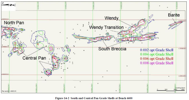
| December 19, 2011 | 76 | |
| Midway Gold Corp. | Mineral Resource Estimates |
| Pan Gold Project Feasibility Study | NI 43-101 Technical Report |
|
14.4.2
|
Grade Shell Estimation
|
Each domain in the North Pan zone consists of two grade boundaries representing 0.004 and 0.008 opt, and each domain in the Central and South Pan zones consists of four grade boundaries representing 0.002, 0.004, 0.006 and 0.008 opt gold assays.
There are potential bias problems with cyanide solution assays appearing lower than the corresponding fire assays. Cyanide solution samples were used to estimate data outside of the interpreted mineralized zones in order to limit their effect on the overall grade of the resource model, as they can be up to 24% lower than the corresponding fire assay. In the North Pan zone this was done by limiting the use of the AuCN data to the inferred resource estimation. In the Central and South Pan zones this was done by estimating the blocks outside of the + 0.004 opt grade shell using both fire assay and cyanide assay data.
|
14.4.2.1
|
North Pan
|
No additional drilling has been completed in the North Pan zone, and the resource estimate published in the Pan Gold Project Pre-Feasibility Study NI 43-101 Technical Report dated April 4th, 2011 is still valid and was used for this report. The previous North Pan resource estimate included a limited portion of the Syncline target area, which has been reallocated to the Central Pan zone. The Northeast and Northwest domain estimates are not impacted by the addition of the Central Pan zone to the resource.
|
14.4.2.2
|
Central and South Pan
|
This updated resource estimate is based in part on additional data from 33 new reverse circulation drill holes in the South Pan zone, and newly interpreted geology of the Central Pan zone. The two separate block models used in the previous resource estimate were extended and combined across Central Pan to create a single coherent block model for use in the current estimate. Grade boundaries in the Central and South Pan domains were estimated at 0.002, 0.004, 0.006 and 0.008 opt gold assay values. The estimation below the 0.004 opt was done using all available assay data (both AuFA and AuCN), while those at + 0.004, + 0.006, and + 0.008 utilize only the AuFA data.
The grade boundary solids were used to code the block model and drill hole assays to the domains. Blocks codes were restricted to the grade boundaries on either side of that being estimated, i.e. blocks within the 0.004 grade boundary used the closest samples from within the + 0.002, + 0.004, and + 0.006 boundary for grade estimation. Summary statistics of the coded drill hole samples are presented in Table 14-2. Statistically the Barite zone is not differentiated from the South Breccia Zone as it is the same style mineralization with a different orientation.
| December 19, 2011 | 77 | |
| Midway Gold Corp. | Mineral Resource Estimates |
| Pan Gold Project Feasibility Study | NI 43-101 Technical Report |
Table 14-2 Pan Project Raw Assay Summary Statistics Au ≥ 0.001 opt
|
South and Central Pan Sample Assay Summary Statistics Au ≥ 0.001 opt
|
|||||
|
Mineral Domain
|
Sample
Count |
Maximum
|
Mean
|
Median
|
Variance
|
|
n
|
opt
|
opt
|
opt
|
opt
|
|
|
Central
|
2277
|
0.015
|
0.001
|
0.000
|
0.000
|
|
Central 0.002
|
1018
|
0.026
|
0.002
|
0.001
|
0.000
|
|
Central 0.004
|
614
|
0.049
|
0.004
|
0.002
|
0.005
|
|
Central 0.006
|
444
|
0.067
|
0.006
|
0.003
|
0.007
|
|
Central 0.008
|
1190
|
0.171
|
0.017
|
0.011
|
0.020
|
|
South Pan Bxa
|
1469
|
0.010
|
0.001
|
0.001
|
0.000
|
|
South Pan Breccia 0.002
|
944
|
0.032
|
0.003
|
0.002
|
0.000
|
|
South Pan Breccia 0.004
|
473
|
0.053
|
0.005
|
0.004
|
0.000
|
|
South Pan Breccia 0.006
|
575
|
0.048
|
0.007
|
0.005
|
0.000
|
|
South Pan Breccia 0.008
|
4011
|
0.254
|
0.022
|
0.016
|
0.000
|
|
Wendy Transition
|
814
|
0.015
|
0.001
|
0.001
|
0.000
|
|
Wendy Transition 0.002
|
537
|
0.032
|
0.003
|
0.002
|
0.000
|
|
Wendy Transition 0.004
|
178
|
0.052
|
0.005
|
0.003
|
0.000
|
|
Wendy Transition 0.006
|
104
|
0.031
|
0.006
|
0.004
|
0.000
|
|
Wendy Transition 0.008
|
769
|
0.292
|
0.018
|
0.011
|
0.001
|
|
Wendy
|
1311
|
0.010
|
0.001
|
0.000
|
0.000
|
|
Wendy Zone 0.002
|
540
|
0.022
|
0.003
|
0.002
|
0.000
|
|
Wendy Zone 0.004
|
392
|
0.028
|
0.005
|
0.004
|
0.000
|
|
Wendy Zone 0.006
|
331
|
0.035
|
0.007
|
0.005
|
0.000
|
|
Wendy Zone 0.008
|
769
|
0.292
|
0.018
|
0.011
|
0.001
|
| December 19, 2011 | 78 | |
| Midway Gold Corp. | Mineral Resource Estimates |
| Pan Gold Project Feasibility Study | NI 43-101 Technical Report |
|
14.5
|
Compositing
|
Twenty-foot downhole composites were created from the gold assays and confined to each of the domain solids and grade shells. The composites were then used for the grade capping analysis and variography for each domain solid. Table 14-3 presents the composite data for each domain.
Table 14-3 Domain Composite Data
|
South and Central Pan Composite Assay Summary Statistics Au ≥ 0.001 opt
|
|||||
|
Mineral Domain
|
Sample
Count |
Maximum
|
Mean
|
Median
|
Variance
|
|
n
|
opt
|
opt
|
opt
|
opt
|
|
|
Central
|
624
|
0.008
|
0.001
|
0.001
|
0.000
|
|
Central 0.002
|
270
|
0.012
|
0.002
|
0.002
|
0.000
|
|
Central 0.004
|
164
|
0.015
|
0.004
|
0.003
|
0.000
|
|
Central 0.006
|
113
|
0.019
|
0.006
|
0.005
|
0.000
|
|
Central 0.008
|
310
|
0.152
|
0.017
|
0.013
|
0.000
|
|
South Pan Breccia
|
464
|
0.004
|
0.001
|
0.001
|
0.000
|
|
South Pan Breccia 0.002
|
282
|
0.020
|
0.003
|
0.002
|
0.000
|
|
South Pan Breccia 0.004
|
115
|
0.038
|
0.005
|
0.004
|
0.000
|
|
South Pan Breccia 0.006
|
150
|
0.025
|
0.007
|
0.006
|
0.000
|
|
South Pan Breccia 0.008
|
1046
|
0.017
|
0.021
|
0.018
|
0.000
|
|
Wendy Transition
|
346
|
0.004
|
0.001
|
0.000
|
0.000
|
|
Wendy Transition 0.002
|
148
|
0.011
|
0.003
|
0.003
|
0.000
|
|
Wendy Transition 0.004
|
97
|
0.010
|
0.005
|
0.004
|
0.000
|
|
Wendy Transition 0.006
|
85
|
0.018
|
0.006
|
0.006
|
0.000
|
|
Wendy Transition 0.008
|
196
|
0.210
|
0.018
|
0.013
|
0.000
|
|
Wendy
|
225
|
0.005
|
0.001
|
0.001
|
0.000
|
|
Wendy Zone 0.002
|
144
|
0.010
|
0.002
|
0.002
|
0.000
|
|
Wendy Zone 0.004
|
42
|
0.018
|
0.005
|
0.004
|
0.000
|
|
Wendy Zone 0.006
|
28
|
0.027
|
0.007
|
0.006
|
0.000
|
|
Wendy Zone 0.008
|
39
|
0.078
|
0.018
|
0.015
|
0.000
|
|
14.6
|
Capping of Assays
|
The following paragraphs summarize information reported by MIDWAY (2009) and independently verified by Gustavson during the Prefeasibility Study.
Cumulative probability plots were created for 10-foot, 20-foot and 50-foot composites. These plots were completed for each domain and for all of the composites within all zones together. Analysis showed no significant influence of higher-grade samples to the final estimate of grade or tonnage of the deposit.
| December 19, 2011 | 79 | |
| Midway Gold Corp. | Mineral Resource Estimates |
| Pan Gold Project Feasibility Study | NI 43-101 Technical Report |
A similar result was obtained by an analysis that AMEC completed for an internal resource estimate of the Pan deposit (AMEC, May 9, 2008). This analysis was based upon a metal-at-risk Monte Carlo Simulation. For this simulation, two probability distributions are created, each representing the real distribution of the high grade and nominal grades of the deposit. The simulation creates drill hole results for thousands of samples based upon each of the distributions. It then uses the results to estimate a tonnage to be mined from both of the populations on a yearly basis. Based on the results of this analysis, AMEC concluded that less then 1.7% of the metal in the deposit is at risk and that capping of the Pan deposit was not warranted.
Based on the analyses completed by MIDWAY and by AMEC, no capping was applied to the Pan assay data or composites.
Gustavson generated cumulative frequency plots for each of the newly defined domains to evaluate capping with the additional drilling samples from the 2010 and 2011 drilling programs. No evidence of extreme high grade outliers was found in the analysis, and no capping was applied to the samples or composites used in the resource estimation.
|
14.7
|
Variography
|
Variography analysis was completed for all seven estimation domains to establish the spatial variability of mineralization within each domain. Variography establishes the appropriate contribution that any specific composite should have when estimating a block volume value within a model. This is performed by comparing the orientation and distance used in the estimation to the variability of other samples of similar relative direction and distance. An example of a spherical variogram constructed from the major axis of the South Pan Breccia domain using a “Pairwise Relative” method of organizing of the variance pairs is shown in Figure 14-3.
Variograms were created for both horizontal and vertical orientations within each domain increment of 15° between orientations. Search ellipsoid axis orientations were based on the results of that analysis. The sill and nugget values for each domain were taken from the omni-directional variograms. The resultant variogram parameters are shown in Table 14-4.
| December 19, 2011 | 80 | |
| Midway Gold Corp. | Mineral Resource Estimates |
| Pan Gold Project Feasibility Study | NI 43-101 Technical Report |

Table 14-4 Pan Variogram Parameters
|
Primary Axis
|
|||||||
|
North Breccia
|
North West
|
Central
|
South Breccia
|
Wendy Transition
|
Wendy
|
Barite
|
|
|
Strike
|
Isotropic
|
255
|
255
|
0
|
350
|
323
|
340
|
|
Plunge
|
0
|
0
|
-10
|
5
|
0
|
10
|
|
|
Secondary Axis
|
|||||||
|
Dip Direction
|
Isotropic
|
345
|
345
|
270
|
260
|
53
|
250
|
|
Dip
|
0
|
0
|
-85
|
-85
|
-63
|
-85
|
|
|
Model Type
|
Spherical
|
Spherical
|
Spherical
|
Spherical
|
Spherical
|
Spherical
|
Spherical
|
|
C0
|
0.213
|
0.212
|
0.391
|
0.303
|
0.262
|
0.419
|
0.303
|
|
C1
|
0.431
|
0.414
|
0.609
|
0.425
|
0.372
|
0.452
|
0.425
|
|
C2
|
0.356
|
0.374
|
---
|
0.272
|
0.366
|
0.130
|
0.272
|
|
Range1
|
68
|
100
|
192
|
72
|
50
|
60
|
72
|
|
Range2
|
158
|
174
|
---
|
210
|
130
|
160
|
210
|
| December 19, 2011 | 81 | |
| Midway Gold Corp. | Mineral Resource Estimates |
| Pan Gold Project Feasibility Study | NI 43-101 Technical Report |
|
14.8
|
Estimation Methodology
|
A Block model was created for the Pan deposit using blocks that are 20 feet wide, 20 feet long and 20 feet high. Each of the blocks was assigned attributes of gold grade, resource classification, rock density, tonnage factor, lithology, alteration, and a grade domain classification. The blocks were then assigned densities and domain assignments as appropriate to assist in estimation.
|
14.8.1
|
North Pan
|
All of the domains were estimated in 3 passes and each block was assigned a classification of measured, indicated, or inferred based on the parameters in Table 14-4. The resource classification of each block was based on a factor of the average sample distance in an anisotropic direction as established by the second structure range (Table 14-3) from the variogram model for the domain being estimated. The measured class utilized a ½ ellipsoid variogram search distance. Indicated was set at a full variogram search distance and inferred was set at 2 times the variogram distance. As an additional requirement, Gustavson limited the measured and indicated estimation data to include only the fire assay intervals. Inferred resource was estimated using all available assay data.
|
14.8.2
|
Central and South Pan
|
All of the domains were estimated by using large search ellipses oriented in the direction of maximum continuity to provide an estimation of the gold grade within every block inside of the grade shells. The resource classification of each block was based on a factor of the closest sample distance in an anisotropic direction as established by the second structure range (Table 14-3) from the variogram model for the domain being estimated. The measured class utilized a ½ ellipsoid variogram search distance. Indicated was set at a full variogram search distance and inferred was set at 2 times the variogram distance. Each domain was estimated using a minimum of 5 composites with no more than 4 composites from a single drill hole. A maximum of 12 composites was allowed to better represent the local variability.
Ordinary Kriging was used to estimate grade for all domains. Estimation parameters for each of the domains are given in Tables 14-5 through 14-7
| December 19, 2011 | 82 | |
| Midway Gold Corp. | Mineral Resource Estimates |
| Pan Gold Project Feasibility Study | NI 43-101 Technical Report |
Table 14-5 Pan Estimation Parameters
|
Domain
|
North Breccia
|
North West
|
||||
|
# of composites
|
Measured
|
Indicated
|
Inferred
|
Measured
|
Indicated
|
Inferred
|
|
1st Pass
|
2nd Pass
|
3rd Pass
|
1st Pass
|
2nd Pass
|
3rd Pass
|
|
|
Min
|
3
|
3
|
2
|
3
|
3
|
2
|
|
Max
|
8
|
12
|
12
|
8
|
12
|
12
|
|
Max per Hole
|
2
|
2
|
4
|
2
|
2
|
4
|
|
Search Ellipsoid Distance (feet)
|
||||||
|
Primary
|
79
|
158
|
316
|
87
|
174
|
348
|
|
Secondary
|
79
|
158
|
316
|
45
|
90
|
180
|
|
Tertiary
|
79
|
158
|
316
|
30
|
60
|
120
|
Table 14-6 Pan Estimation Parameters
|
Domain
|
South Breccia
|
Wendy Transition
|
Wendy
|
||||||
|
# of Composites
|
|||||||||
|
Min
|
5
|
5
|
5
|
||||||
|
Max
|
12
|
12
|
12
|
||||||
|
Max per Hole
|
4
|
4
|
4
|
||||||
|
Search Ellipsoid Distance (feet)
|
|||||||||
|
Measured
|
Indicated
|
Inferred
|
Measured
|
Indicated
|
Inferred
|
Measured
|
Indicated
|
Inferred
|
|
|
Primary
|
105
|
210
|
420
|
65
|
130
|
260
|
80
|
160
|
320
|
|
Secondary
|
90
|
180
|
360
|
47
|
94
|
188
|
62
|
124
|
248
|
|
Tertiary
|
23
|
46
|
92
|
22
|
44
|
88
|
62
|
124
|
248
|
Table 14-7 Pan Estimation Parameters
|
Domain
|
Barite
|
Central
|
||||
|
Min
|
5
|
5
|
||||
|
Max
|
12
|
12
|
||||
|
Max per Hole
|
4
|
4
|
||||
|
Search Ellipsoid Distance (feet)
|
||||||
|
Measured
|
Indicated
|
Inferred
|
Measured
|
Indicated
|
Inferred
|
|
|
Primary
|
105
|
210
|
420
|
96
|
192
|
384
|
|
Secondary
|
90
|
180
|
360
|
66
|
132
|
264
|
|
Tertiary
|
23
|
46
|
92
|
65
|
130
|
260
|
| December 19, 2011 | 83 | |
| Midway Gold Corp. | Mineral Resource Estimates |
| Pan Gold Project Feasibility Study | NI 43-101 Technical Report |
|
14.9
|
Estimate Validation
|
The model was validated by examining the blocks with actual drill hole assay data to determine if the estimated blocks fit the geologic parameters of the various domains of the deposit. Both assay and geological constraints were visually examined. A bench plan at an elevation 6600 feet displaying the block model gold content with the composite gold data and grade shells is presented in Figure 14-4.
| December 19, 2011 | 84 | |
| Midway Gold Corp. | Mineral Resource Estimates |
| Pan Gold Project Feasibility Study | NI 43-101 Technical Report |

| December 19, 2011 | 85 | |
| Midway Gold Corp. | Mineral Resource Estimates |
| Pan Gold Project Feasibility Study | NI 43-101 Technical Report |
|
14.10
|
Mineral Resource Classification
|
The mineral resources at Pan are classified as measured, indicated, and inferred in accordance with CIM Definition Standards for Mineral Resources and Mineral Reserves.
|
14.11
|
Mineral Resource Tabulation
|
The mineral resource estimate is summarized in Tables 14-8 through 14-11. This mineral resource estimate includes all drill data obtained as of September 1, 2011 and has been independently verified by Gustavson.
Table 14-8 North Pan Mineral Resource
|
North Pan Measured Resource
|
|||
|
Opt
|
Tons
|
Au Opt
|
oz
|
|
0.008
|
13,994,415
|
0.0168
|
234,844
|
|
0.006
|
15,592,007
|
0.0158
|
245,850
|
|
0.004
|
18,597,319
|
0.0140
|
260,404
|
|
North Pan Indicated Resource
|
|||
|
0.008
|
10,565,126
|
0.0146
|
154,540
|
|
0.006
|
12,702,959
|
0.0133
|
169,135
|
|
0.004
|
17,006,845
|
0.0112
|
189,823
|
|
North Pan Measured plus Indicated Resource
|
|||
|
0.008
|
24,559,541
|
0.0159
|
389,384
|
|
0.006
|
28,294,966
|
0.0147
|
414,985
|
|
0.004
|
35,604,164
|
0.0126
|
450,228
|
|
North Pan Inferred Resource
|
|||
|
0.008
|
122,858
|
0.0112
|
1,376
|
|
0.006
|
233,476
|
0.0091
|
2,129
|
|
0.004
|
511,402
|
0.0067
|
3,427
|
| December 19, 2011 | 86 | |
| Midway Gold Corp. | Mineral Resource Estimates |
| Pan Gold Project Feasibility Study | NI 43-101 Technical Report |
Table 14-9 Central Pan Mineral Resource
|
Central Pan Measured Resource
|
|||
|
Opt
|
Tons
|
Au Opt
|
oz
|
|
0.008
|
2,329,227
|
0.0146
|
33,991
|
|
0.006
|
2,837,448
|
0.0132
|
37,482
|
|
0.004
|
3,802,537
|
0.0111
|
42,192
|
|
Central Pan Indicated Resource
|
|||
|
0.008
|
1,895,266
|
0.0122
|
23,216
|
|
0.006
|
2,524,520
|
0.0109
|
27,623
|
|
0.004
|
4,053,056
|
0.0086
|
34,885
|
|
Central Pan Measured plus Indicated Resource
|
|||
|
0.008
|
4,224,493
|
0.0135
|
57,207
|
|
0.006
|
5,361,968
|
0.0121
|
65,105
|
|
0.004
|
7,855,593
|
0.0098
|
77,077
|
|
Central Pan Inferred Resource
|
|||
|
0.008
|
240,912
|
0.0103
|
2,470
|
|
0.006
|
290,465
|
0.0096
|
2,802
|
|
0.004
|
722,079
|
0.0066
|
4,741
|
Table 14-10 South Pan Mineral Resource
|
South Pan Measured Resource
|
|||
|
Opt
|
Tons
|
Au Opt
|
oz
|
|
0.008
|
13,826,998
|
0.0182
|
251,350
|
|
0.006
|
15,584,480
|
0.0169
|
263,423
|
|
0.004
|
18,297,337
|
0.0151
|
276,641
|
|
South Pan Indicated Resource
|
|||
|
0.008
|
17,440,794
|
0.0158
|
275,596
|
|
0.006
|
20,764,856
|
0.0144
|
298,599
|
|
0.004
|
26,469,130
|
0.0123
|
325,863
|
|
South Pan Measured plus Indicated Resource
|
|||
|
0.008
|
31,267,792
|
0.0169
|
526,946
|
|
0.006
|
36,349,336
|
0.0155
|
562,022
|
|
0.004
|
44,766,467
|
0.0135
|
602,504
|
|
South Pan Inferred Resource
|
|||
|
0.008
|
1,588,716
|
0.0184
|
29,274
|
|
0.006
|
1,933,540
|
0.0164
|
31,651
|
|
0.004
|
3,096,599
|
0.0120
|
37,093
|
| December 19, 2011 | 87 | |
| Midway Gold Corp. | Mineral Resource Estimates |
| Pan Gold Project Feasibility Study | NI 43-101 Technical Report |
Table 14-11 Total Pan Mineral Resource
|
Pan Total Measured Resource
|
|||
|
Opt
|
Tons
|
Au Opt
|
oz
|
|
0.008
|
30,150,640
|
0.0173
|
520,186
|
|
0.006
|
34,013,935
|
0.0161
|
546,756
|
|
0.004
|
40,697,193
|
0.0142
|
579,238
|
|
Pan Total Indicated Resource
|
|||
|
0.008
|
29,901,186
|
0.0152
|
453,351
|
|
0.006
|
35,992,335
|
0.0138
|
495,357
|
|
0.004
|
47,529,031
|
0.0116
|
550,571
|
|
Pan Total Measured plus Indicated Resource
|
|||
|
0.008
|
60,051,826
|
0.0162
|
973,537
|
|
0.006
|
70,006,270
|
0.0149
|
1,042,112
|
|
0.004
|
88,226,224
|
0.0128
|
1,129,809
|
|
Pan Total Inferred Resource
|
|||
|
0.008
|
1,952,486
|
0.0170
|
33,120
|
|
0.006
|
2,457,481
|
0.0149
|
36,581
|
|
0.004
|
4,330,080
|
0.0105
|
45,261
|
| December 19, 2011 | 88 | |
| Midway Gold Corp. | Mineral Reserve Estimates |
| Pan Gold Project Feasibility Study | NI 43-101 Technical Report |
|
15
|
MINERAL RESERVE ESTIMATES
|
The February 2011 Prefeasibility Study demonstrated that the Pan Project is economically viable, and this Feasibility Study has strengthened that conclusion. Based on the results of the Feasibility Study, Measured and Indicated Mineral Reserves within the designed pits are considered Proven and Probable Reserves according to CIM Definition Standards. The final reserves are reported using a 0.008 Au opt cutoff for the North and Central pits, and a 0.006 Au opt cutoff for the South pit. Cutoffs were chosen to maximize the NPV of the project and do not necessarily represent the minimum economic cutoff. Pit designs are based on geologic criteria provided in the April 2011 Pit Slope Evaluation report produced by Golder Associates. Geologic solids created for each lithological unit were used as a guide during the pit design process. The limestone units were designed with a 50° inter-ramp wall angle assuming pre-split blasting in these units; all other lithological units were designed with a 45° inter-ramp wall angle.
|
15.1.1
|
Whittle Pit Optimization
|
Gustavson generated a series of optimization shells on the South and North resource blocks ranging from $236/oz to $2360/oz. Forty six shells were generated separately on the North and South resource areas using a gold price of $1180/oz. Heap leach recoveries of 65% and 85% for North and South Pan, respectively, were used in the optimization runs. The general parameters were based upon preliminary estimates of operating cost and incorporated recommendations from Golder’s April 2011 geotechnical report. Mining costs were estimated to be $1.09/ton of material moved for the pit optimization. Crushing agglomeration, leaching, general and administration and gold recovery costs were estimated at $3.71/ton of ore. Only Measured and Indicated Resources were considered in the evaluation, Inferred resources were treated as waste.
|
15.1.2
|
Calculation Parameters
|
The series of pit optimizations were graphed and evaluated to compare cash flows, net present values (NPV’s) and internal rates of return (IRR’s). The final South pit and the North pit optimizations are based on shells at a gold price less than the average price of $1180/oz in order to achieve a higher NPV and overall lower cash cost per ounce. The option of mining the entire South Pan pit before the North Pan pit was evaluated during the scheduling process. Although the South Pan pit has a 20% higher recovery factor, mining the South Pan in phases results in a higher IRR by delaying the high strip of the Phase 2 South Pit until the end of the mine life. The option of mining the North pit first was also evaluated, but the higher recovery from the South Pan pit (85%, compared to 65% from North Pan) and shorter estimated leach times render the South pit the more favorable option to mine first.
|
15.1.2.1
|
Cutoff Grade Equations
|
The mineral reserve estimate for the Pan Project is based on designed open pits with maximized revenues at an average gold price of $1180 per ounce. Cutoff grades of 0.006 Au opt (0.21 gpt)
| December 19, 2011 | 89 | |
| Midway Gold Corp. | Mineral Reserve Estimates |
| Pan Gold Project Feasibility Study | NI 43-101 Technical Report |
in the South pit and 0.008 Au opt (0.27 gpt) in the North and Central pits provide the highest NPV for the project. Table 15-1 shows the calculated cutoffs based on the three year trailing average gold price ($1,200/oz) and projected operating costs. The chosen cutoffs which are fairly close to the economic cutoffs produce the best economics results for NPV, IRR and cash cost per ounce.
Table 15-1 Calculated Cutoffs
|
North Pit
|
|||||||
|
Economic Cutoff @
|
$ 1,200
|
Mining Cuttoff @
|
$ 850
|
$ 1,200
|
|||
|
Cost Center
|
Cost Center
|
||||||
|
Mining
|
$/ore ton
|
$ 2.78
|
Mining
|
$/ore ton
|
$ -
|
$ -
|
|
|
Processing
|
$/ore ton
|
$ 2.58
|
Processing
|
$/ore ton
|
$ 2.65
|
$ 2.58
|
|
|
G&A
|
$/ore ton
|
$ 0.37
|
G&A
|
$/ore ton
|
$ 0.38
|
$ 0.37
|
|
|
Recoveries
|
ton
|
65%
|
Recoveries
|
ton
|
70%
|
65%
|
|
|
Royalties
|
gross
|
4%
|
Royalties
|
gross
|
4%
|
4%
|
|
|
refining cost
|
per/oz
|
$ 5.00
|
refining cost
|
per/oz
|
$ 5.00
|
$ 5.00
|
|
|
total cost
|
ore/ton
|
$ 5.73
|
total cost
|
ore/ton
|
$ 3.03
|
$ 2.95
|
|
|
Gold Selling Price
|
oz
|
$ 1,200
|
Gold Selling Price
|
oz
|
$ 850
|
$ 1,200
|
|
|
Cutoff Grade
|
opt
|
0.0074
|
Cutoff Grade
|
opt
|
0.0051
|
0.0038
|
|
|
South Pit
|
|||||||
|
Economic Cutoff @
|
$ 1,200
|
Mining Cuttoff @
|
$ 850
|
$ 1,200
|
|||
|
Cost Center
|
Cost Center
|
||||||
|
Mining
|
$/ore ton
|
$ 2.78
|
Mining
|
$/ore ton
|
$ -
|
$ -
|
|
|
Processing
|
$/ore ton
|
$ 2.58
|
Processing
|
$/ore ton
|
$ 2.65
|
$ 2.58
|
|
|
G&A
|
$/ore ton
|
$ 0.37
|
G&A
|
$/ore ton
|
$ 0.38
|
$ 0.37
|
|
|
Recoveries
|
ton
|
85%
|
Recoveries
|
ton
|
80%
|
85%
|
|
|
Royalties
|
gross
|
4%
|
Royalties
|
gross
|
4%
|
4%
|
|
|
refining cost
|
per/oz
|
$ 5.00
|
refining cost
|
per/oz
|
$ 5.00
|
$ 5.00
|
|
|
total cost
|
ore/ton
|
$ 5.73
|
total cost
|
ore/ton
|
$ 3.03
|
$ 2.95
|
|
|
Gold Selling Price
|
oz
|
$ 1,200
|
Gold Selling Price
|
oz
|
$ 850
|
$ 1,200
|
|
|
Cutoff Grade
|
opt
|
0.0056
|
Cutoff Grade
|
opt
|
0.0045
|
0.0029
|
|
|
151.3
|
Mineral Reserve Estimate
|
Using the NI 43-101 Updated Mineral Resource Estimate filed in November 2011, Proven and Probable Reserves of 53,254,000 tons at a grade of 0.016 opt are contained in the mineral resource at Pan. A total of 864,000 oz of gold are contained in the Pan Project mineral reserves. Estimated mineral reserves for the Pan Project are presented in Tables 15-2 and 15-3.
| December 19, 2011 | 90 | |
| Midway Gold Corp. | Mineral Reserve Estimates |
| Pan Gold Project Feasibility Study | NI 43-101 Technical Report |
Table 15-2 North and Central Pan Mineral Reserves
|
North and Central Pan
|
Tons
|
Gold
|
|
|
Cutoff Grade:
|
(x 1000)
|
opt
|
ounces (x 1000)
|
|
0.008 opt / 0.274 g/tonnes
|
|||
|
North Pan
|
|||
|
Proven Reserves
|
12,625
|
0.018
|
223.30
|
|
Probable Reserves
|
10,993
|
0.015
|
162.66
|
|
Proven & Probable Reserves
|
23,618
|
0.016
|
385.95
|
|
Inferred within Designed Pit
|
351
|
0.012
|
4.29
|
|
Waste within Designed Pit
|
27,823
|
||
|
Total tons within Designed Pit
|
51,791
|
||
|
Central Pan
|
|||
|
Proven Reserves
|
1,799
|
0.015
|
27.78
|
|
Probable Reserves
|
1,125
|
0.013
|
15.00
|
|
Proven & Probable Reserves
|
2,924
|
0.015
|
42.78
|
|
Inferred within Designed Pit
|
75
|
0.010
|
0.77
|
|
Waste within Designed Pit
|
5,387
|
||
|
Total tons within Designed Pit
|
8,386
|
||
|
Sub Total - North + Central
|
|||
|
Proven Reserves
|
14,423
|
0.017
|
251.08
|
|
Probable Reserves
|
12,119
|
0.015
|
177.66
|
|
Proven & Probable Reserves
|
26,542
|
0.016
|
428.74
|
|
Inferred within Designed Pit
|
426
|
0.012
|
5.06
|
|
Waste within Designed Pit
|
33,210
|
||
|
Total tons within Designed Pit
|
60,177
|
||
| December 19, 2011 | 91 | |
| Midway Gold Corp. | Mineral Reserve Estimates |
| Pan Gold Project Feasibility Study | NI 43-101 Technical Report |
Table 15-3 South Pan and Total Pan Project Mineral Reserves
|
South Pan - Phases 1 and 2
|
Tons
|
Gold
|
|
|
Cutoff Grade:
|
(x 1000)
|
opt
|
ounces (x 1000)
|
|
0.006 opt / 0.206 g/tonnes
|
|||
|
South Pan - Phase 1
|
|||
|
Proven Reserves
|
11,856
|
0.018
|
215.44
|
|
Probable Reserves
|
7,593
|
0.016
|
119.26
|
|
Proven & Probable Reserves
|
19,449
|
0.017
|
334.70
|
|
Inferred within Designed Pit
|
56
|
0.010
|
0.55
|
|
Waste within Designed Pit
|
31,887
|
||
|
Total tons within Designed Pit
|
51,392
|
||
|
South Pan - Phase 2
|
|||
|
Proven Reserves
|
1,548
|
0.014
|
21.01
|
|
Probable Reserves
|
5,716
|
0.014
|
79.80
|
|
Proven & Probable Reserves
|
7,263
|
0.014
|
100.81
|
|
Inferred within Designed Pit
|
212
|
0.016
|
3.39
|
|
Waste within Designed Pit
|
29,485
|
||
|
Total tons within Designed Pit
|
36,961
|
||
|
Sub Total - Phase 1 + 2
|
|||
|
Proven Reserves
|
13,404
|
0.018
|
236.46
|
|
Probable Reserves
|
13,308
|
0.015
|
199.05
|
|
Proven & Probable Reserves
|
26,713
|
0.016
|
435.51
|
|
Inferred within Designed Pit
|
269
|
0.015
|
3.94
|
|
Waste within Designed Pit
|
61,372
|
||
|
Total tons within Designed Pit
|
88,353
|
||
|
Total Reserves
|
Tons
|
Gold
|
|
|
(x 1000)
|
opt
|
ounces (x 1000)
|
|
|
Proven Reserves
|
27,827
|
0.018
|
487.51
|
|
Probable Reserves
|
25,427
|
0.015
|
376.71
|
|
Proven & Probable Reserves
|
53,254
|
0.016
|
864.22
|
|
Inferred within Designed Pit
|
695
|
0.013
|
9.0
|
|
Waste within Designed Pit
|
94,582
|
||
|
Total tons within Designed Pit
|
148,531
|
||
| December 19, 2011 | 92 | |
| Midway Gold Corp. | Mining Methods |
| Pan Gold Project Feasibility Study | NI 43-101 Technical Report |
|
16
|
MINING METHODS
|
|
16.1
|
Open Pit Mine Plan
|
The Pan gold deposit contains mineralization at or near the surface and spatially distributed in a manner that is ideal for open pit mining methods. Gold grade distribution and the results of preliminary mineral processing testing indicate that ore from the Pan deposit can be processed by conventional heap leaching methods. The method of material transport evaluated for this study is open pit mining using a 21.6-yd3 front end shovel as the main loading unit with a 16-yd3 front end loader as a backup loading unit. The ore will be loaded into 150-ton haul trucks and transported to the primary jaw crusher, which will be set up at the mouth of the pit. The primary jaw crusher is a semi-mobile unit mounted on skids that will be moved to the mouth of whichever pit is being mined. The crushed ore material will be conveyed to the secondary crushing site, crushed to P80 ½-inch (North) and P80 1½-inch (South), agglomerated, and conveyed to the heap leach pad. The waste material will be loaded into the 150-ton haul trucks and hauled directly to the waste dump. The truck haul method was chosen over in-pit mobile crushers and mobile conveyors in order to simplify waste dump construction and allow for more flexibility in day to day mining activities.
MIDWAY will own, operate, and maintain all equipment. The general site layout, including pits, waste dumps, the secondary crusher site, infrastructure, ponds, and heap leach pads, is shown on Figure 16-1.
| December 19, 2011 | 93 | |
| Midway Gold Corp. | Mining Methods |
| Pan Gold Project Feasibility Study | NI 43-101 Technical Report |

| December 19, 2011 | 94 | |
| Midway Gold Corp. | Mining Methods |
| Pan Gold Project Feasibility Study | NI 43-101 Technical Report |
Ore production is planned at a nominal rate of 17,000 tons per day (tpd), equivalent to 6.2 million tons per annum with a 8.8 year mine life. Mining is planned on a 7 day per week schedule, with two 12 hour shifts per day. Peak ore and waste production is estimated at 67,000 tpd. The average life of mine stripping ratio is 1.79:1 waste-to-ore, using a 0.006 Au oz/ton cutoff for the South Pan pit and a 0.008 Au oz/ton cutoff on the North and Central pits. The change in cutoffs from one pit to the next are a result of the metallurgical recovery testing which showed the South pit has an expected average recovery of 85% and the North pit has an expected recovery of 65%. Other cutoff scenarios were evaluated using 0.004, 0.006 and 0.008 Au oz/ton, but the scenario presented here provides the best IRR and NPV at a 5% discount rate.
|
161.1.1
|
Pit Design
|
Whittle-generated pit surfaces, which maximized revenue based on the estimated average of $1,180 per ounce gold, were used in conjunction with the Pan block model to design the open pits with haul roads and catch benches for North Pan, Central Pan, and South Pan. Pit designs are based in part on geologic criteria provided in the April 2011 Prefeasibility Level Pit Slope Evaluation report produced by Golder Associates. Geologic solids created for each lithological unit were used as a guide during the pit design process. The limestone units were designed with a 50° inter-ramp wall angle assuming pre-split blasting in these units, all other lithological units were designed at a 45° inter-ramp wall angle. Haul roads are designed at a width of 90 ft, which provides a safe truck width (23 feet) to running surface width ratio of 3.9. Maximum grade of the haul roads is 10%, except for the lowermost three to five benches where the grade is increased to 12% and the ramp width is narrowed to 50 feet to minimize excessive waste stripping. The pit design criteria are presented in Table 16-1.
Table 16-1 Pit Design Criteria
|
Mine Design Criteria
|
||
|
Pit Design Criteria
|
Limestone Units
|
All Other Rock Units
|
|
Inter-Ramp Angles
|
50 Degrees
|
45 Degrees
|
|
Face Angles
|
70 Degrees
|
63 Degrees
|
|
Catch Bench Berm
|
30 ft.
|
30 ft.
|
|
Catch Bench Vertical Spacing
|
60 ft.
|
60 ft.
|
|
Minimum Turning Radius
|
90 ft.
|
90 ft.
|
|
Road Widths
|
90 ft.
|
90 ft.
|
|
Road Grade
|
10%
|
10%
|
|
Road Widths Pit Bottom
|
50 ft.
|
50 ft.
|
|
Road Grade Pit Bottom
|
12%
|
12%
|
Design of the North Pan pit has not changed considerably from the design considered during the Prefeasibility Study, but the size of the final South Pan pit has approximately doubled. The increase in size of the South Pan pit is based on the positive results of recent drilling in the Wendy target area. The Central Pan pits, which were not considered during the Prefeasibility Study, are located very close to the leach pad and will also provide suitable over-liner material for pad construction. The Central Pan pits will be mined first and then backfilled with waste from the South Pan pit. Design of the South Pan pit includes two phases of construction in order to account for a strip ratio that is considerably higher than the other pit designs. An intermediate pit was also designed near the south end of the North Pan pit to provide a borrow source for over-liner material. The final pit designs are shown in Figure 16-2
| December 19, 2011 | 95 | |
| Midway Gold Corp. | Mining Methods |
| Pan Gold Project Feasibility Study | NI 43-101 Technical Report |
Study, are located very close to the leach pad and will also provide suitable over-liner material for pad construction. The Central Pan pits will be mined first and then backfilled with waste from the South Pan pit. Design of the South Pan pit includes two phases of construction in order to account for a strip ratio that is considerably higher than the other pit designs. An intermediate pit was also designed near the south end of the North Pan pit to provide a borrow source for over-liner material. The final pit designs are shown in Figure 16-2
| December 19, 2011 | 96 | |
| Midway Gold Corp. | Mining Methods |
| Pan Gold Project Feasibility Study | NI 43-101 Technical Report |

| December 19, 2011 | 97 | |
| Midway Gold Corp. | Mining Methods |
| Pan Gold Project Feasibility Study | NI 43-101 Technical Report |
|
161.1.1
|
Geotechnical Pit Slope Evaluation
|
Golder Associates completed a pit slope evaluation in support of a prefeasibility study for the Pan Project in 2011, based in part on the results of their scoping level pit slope evaluation completed in 2010. The following paragraphs summarize the geotechnical recommendations provided by Golder, and additional detailed information is included in the associated report “Pan Project, White Pine County, Nevada, Pre-Feasibility Level Pit Slope Evaluation”, dated April 2011. Gustavson finds the results of Golder’s analysis sufficient for use in the current feasibility level study, provided that the associated recommendations are carried out in conjunction with forthcoming exploration work at the Pan Project.
General Slope Design Recommendations
For bedrock slopes where little potential for rock mass or structural control of overall or inter-ramp slope angles is indicated, achievable pit slope angles will be determined by the bench configurations that can be developed and maintained safely. Bench configurations are defined by production bench height, achievable bench face angle, and catch bench width, all of which combine to define the inter-ramp angle. Since catch bench width for a given bench height is constant according to usual design criteria, maximizing the inter-ramp angle will be contingent on excavating the bench face angle as steep as possible.
The pits are designed with 20-ft high production benches, which is typical for grade control in small gold mines. Stacking benches will be required to achieve moderate to steep inter-ramp slope angles with this small bench height. While it is premature to determine the most suitable bench configuration for optimized slope design, available data indicate that moderate to steep inter-ramp angles should be feasible in the strong rock units, and moderate inter-ramp slope angles should be feasible in the Tertiary volcanics, siltstone, shale, and breccia bodies, provided they are moderately to well indurated and are not highly clay altered.
Pit Slope Design Recommendations
Evaluation of structural data from oriented coring indicates that it should be possible to develop moderately steep bench face angles and inter-ramp slopes. Pit slope design recommendations in Table 16-2 are based on current understanding of geotechnical conditions at the site, and assumptions regarding operating practices as noted.
| December 19, 2011 | 98 | |
| Midway Gold Corp. | Mining Methods |
| Pan Gold Project Feasibility Study | NI 43-101 Technical Report |
Table 16-2 Slope Design Recommendations
|
Geotechnical
Unit
|
Sectors
|
Operating
Practices
|
Bench
Configuration and Height (ft) |
Catch
Bench Width (ft) |
Bench Face
Angle (deg) |
Design Inter-
Ramp Slope Angle (deg) |
|
Massive, Strong Limestone
|
5,7
|
Pre-Split
|
Triple Bench
3X20 ft
60 ft between catch benches
|
29
|
70
|
50
|
|
Siltstone and Shale, Volcanics, Diamond Peak
|
1,2,4,8
|
Cushion Blasting
|
Triple Bench
3X20 ft
60 ft between catch benches
|
30
|
63
1/2 (H):1(V)
|
45
|
|
Breccia Bodies
|
1,2,6
|
Cushion Blasting
|
Triple Bench
3X20 ft
60 ft between catch benches
|
30
|
63
1/2 (H):1(V)
|
45
|
|
Pan Fault Zone
|
3
|
Light Blasting with Hard Digging
|
Triple Bench
3X20 ft
60 ft between catch benches
|
30
|
63
1/2 (H):1(V)
|
45
|
For pit designs, triple benching at the 20-ft high production bench to develop effective catch benches at vertical intervals of 60 ft is recommended. This will enable the development of moderate to steep inter-ramp slopes, but safe development of triple bench configurations will require implementation of effective controlled blasting and scaling to limit rockfall hazards.
Recommended Slope Stability Geotechnical Program
A geotechnical program to support project development should include:
|
●
|
Oriented geotechnical core hole to characterize the Tertiary volcanic rocks in the north slope of the North Pan pit.
|
|
●
|
Oriented geotechnical core hole to characterize the Diamond Peak Formation in the east slope of the North Pan pit.
|
|
●
|
Surface structural mapping to confirm the quality and structural conditions of important units exposed at the surface.
|
|
●
|
Shear testing of clay alteration of the Tertiary volcanic rocks and any units with significant clay alteration, and of weak argillized rock in the breccia bodies at South Pan.
|
|
●
|
Preliminary perimeter blast designs to support equipment selection, and estimates of capital and operating costs.
|
|
●
|
A recommended program of monitoring and slope design optimization.
|
| December 19, 2011 | 99 | |
| Midway Gold Corp. | Mining Methods |
| Pan Gold Project Feasibility Study | NI 43-101 Technical Report |
|
16.1.2
|
Waste Dumps
|
The waste dumps were designed to represent natural terrain and drainages using a geomorphic design concept. The maximum slope angle of the waste dumps is limited to 3:1. The South Pan waste dump is designed with a capacity of 73.5 million tons to accommodate the current design tonnage of 61.6 million and allow for additional expansion of the South pit in the future. The North Pan waste dump has a capacity of 42.3 million tons to accommodate a design tonnage of 33.6 million. A three foot limestone cap will be placed on the waste dumps to limit the potential for acid generating waste on the surface of the dumps. The configurations of the North Pan and South Pan waste dumps are shown on Figure 16-2 above.
The volumes of limestone and non-limestone waste were calculated individually to determine if a sufficient volume of limestone waste is available for construction of the 3-foot caps. The estimated amount of limestone waste needed is about 4% of the total volume of waste per pit. Limestone will account for nearly 50% of the waste from the South Pan pit, and approximately 8% of the waste from the North Pan pit.
|
16.1.3
|
Annual Mine Plans
|
The end of year mine layouts are presented as Figures 16-3 through 16-10. The layouts show the sequencing of mining the Central pits first followed by the phase one South pit and then the North pit with the final stage being the phase two South pit.
| December 19, 2011 | 100 | |
| Midway Gold Corp. | Mining Methods |
| Pan Gold Project Feasibility Study | NI 43-101 Technical Report |
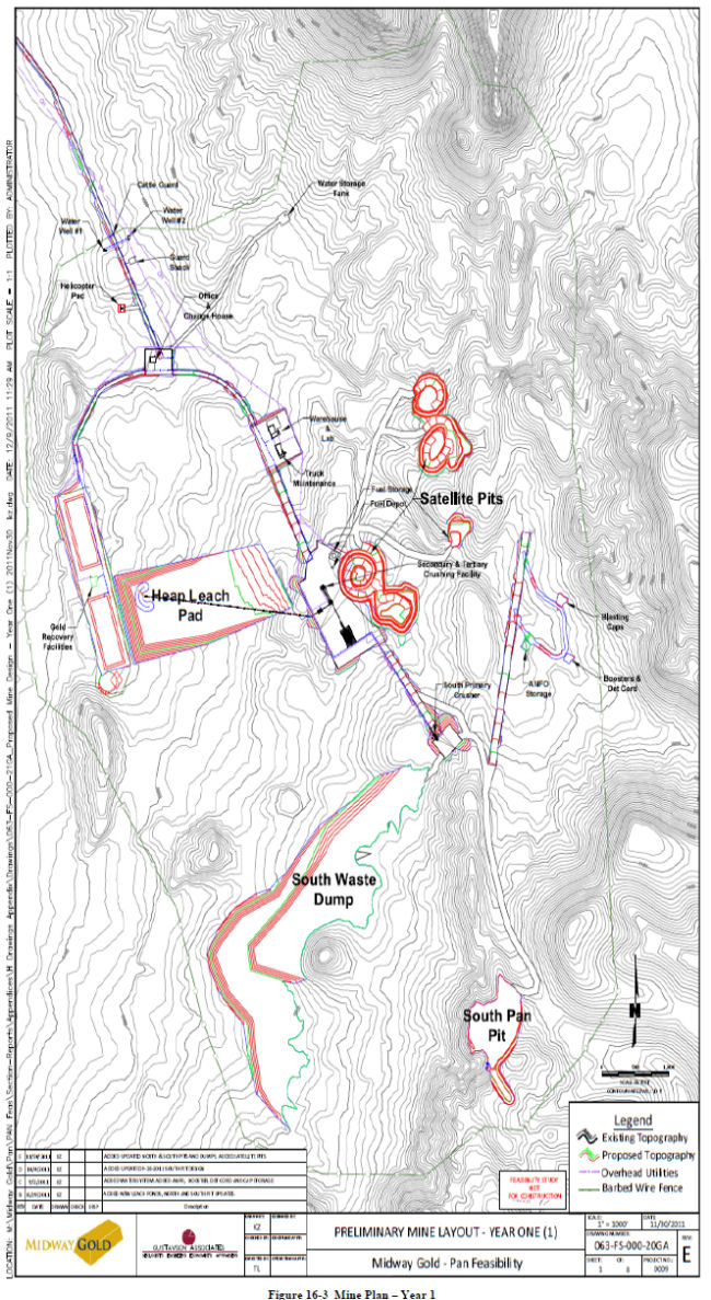
| December 19, 2011 | 101 | |
| Midway Gold Corp. | Mining Methods |
| Pan Gold Project Feasibility Study | NI 43-101 Technical Report |
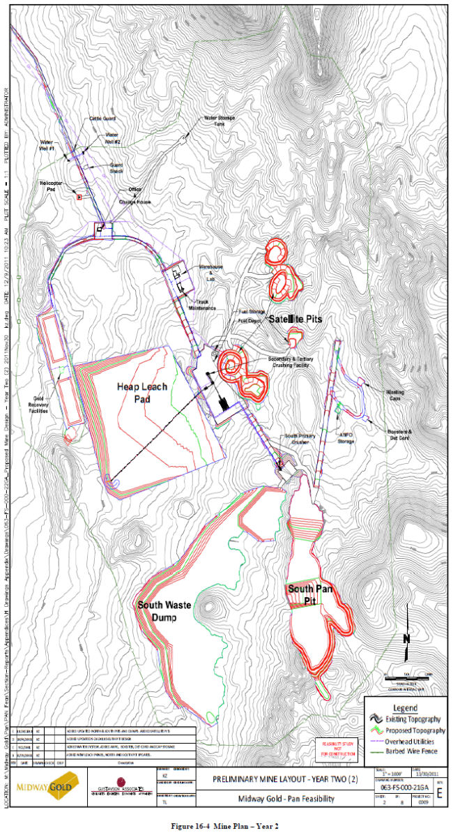
| December 19, 2011 | 102 | |
| Midway Gold Corp. | Mining Methods |
| Pan Gold Project Feasibility Study | NI 43-101 Technical Report |
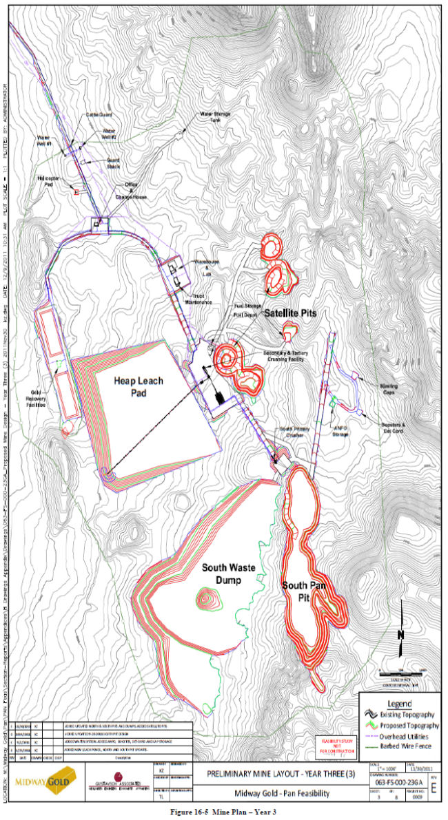
| December 19, 2011 | 103 | |
| Midway Gold Corp. | Mining Methods |
| Pan Gold Project Feasibility Study | NI 43-101 Technical Report |

| December 19, 2011 | 104 | |
| Midway Gold Corp. | Mining Methods |
| Pan Gold Project Feasibility Study | NI 43-101 Technical Report |

| December 19, 2011 | 105 | |
| Midway Gold Corp. | Mining Methods |
| Pan Gold Project Feasibility Study | NI 43-101 Technical Report |

| December 19, 2011 | 106 | |
| Midway Gold Corp. | Mining Methods |
| Pan Gold Project Feasibility Study | NI 43-101 Technical Report |
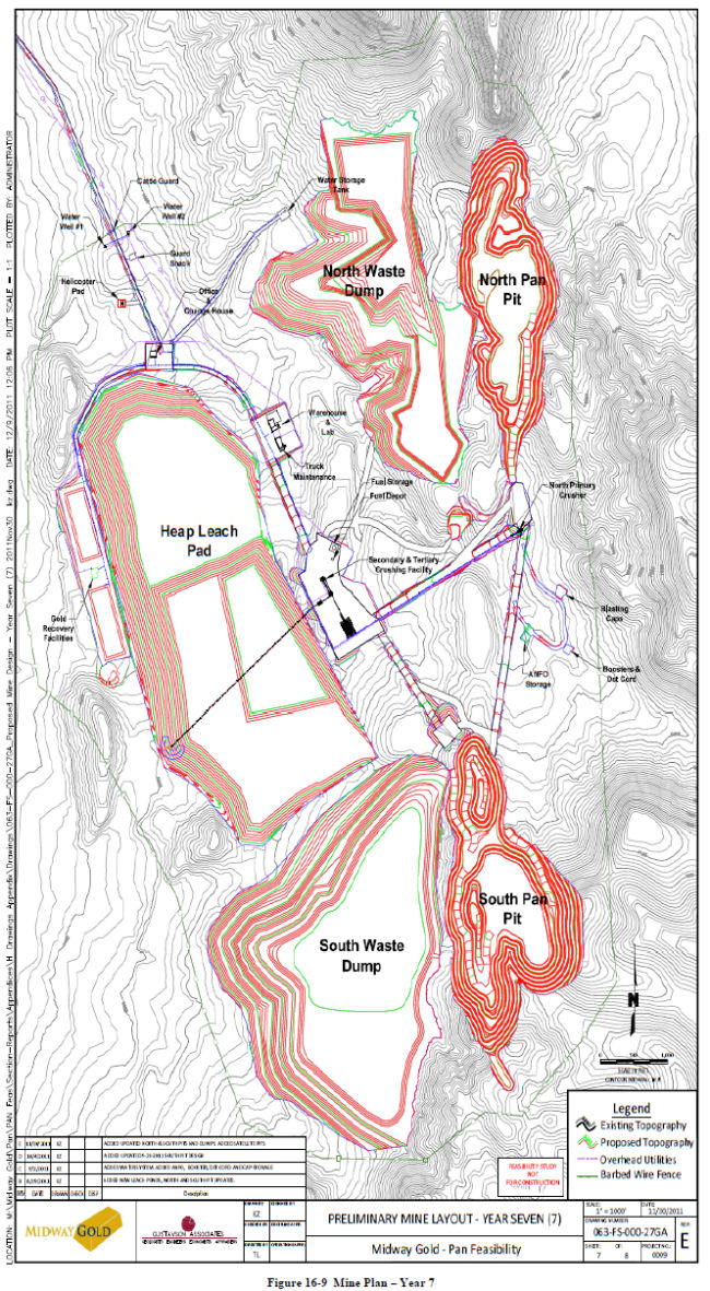
| December 19, 2011 | 107 | |
| Midway Gold Corp. | Mining Methods |
| Pan Gold Project Feasibility Study | NI 43-101 Technical Report |

| December 19, 2011 | 108 | |
| Midway Gold Corp. | Mining Methods |
| Pan Gold Project Feasibility Study | NI 43-101 Technical Report |
|
16.1.4
|
Geotechnical Design- Heap Leach Pad, Ponds, Stormwater Diversions
|
SRK prepared a conceptual design for the heap leach pad (HLP), ponds, and stormwater diversion facilities in November of 2010 for a pre-feasibility analysis and discussions with regulatory agencies (NDEP and BLM). After completion of the conceptual design, SRK supervised targeted site investigations and characterization and completed feasibility-level design.
The results of the feasibility design include the following components:
|
●
|
Section 2.0 Design Criteria and Parameters;
|
|
●
|
Section 3.0 Heap Leach Pad;
|
|
●
|
Section 4.0 Stormwater Controls; and,
|
|
●
|
Section 5.0 Stabilization for Closure.
|
The current mine plan calls for in-pit crushing of ore, transport to the HLP via overland conveyor, and ore loading by jump conveyors and a portable stacker.
|
16.1.5
|
Site Scale Hydrology
|
Site-scale hydrogeologic data are available from on-site boreholes and from a few existing and historical wells in the Pan Project vicinity. Additional shallow and deep monitoring wells are proposed for additional baseline hydrogeologic characterization and monitoring.
Based on existing data, which are summarized in the sections below, groundwater at the project site occurs in a deep, carbonate aquifer and a narrow, shallow alluvial aquifer along the normally dry stream channel west of the proposed mine area. Figure 16-11 presents a conceptual cross section of the proposed mine area. As shown in the figure, shallow alluvial groundwater west of the mine area occurs at elevations that are approximately 500 feet higher than the deep carbonate aquifer. The deep carbonate aquifer is approximately 650 to 800 feet below the proposed heap leach facility and approximately 600 feet below the bottom of the proposed south pit.
| December 19, 2011 | 109 | |
| Midway Gold Corp. | Mining Methods |
| Pan Gold Project Feasibility Study | NI 43-101 Technical Report |

| December 19, 2011 | 110 | |
| Midway Gold Corp. | Mining Methods |
| Pan Gold Project Feasibility Study | NI 43-101 Technical Report |
|
16.1.5.1
|
Deep Bedrock Aquifer
|
Ten deep boreholes have been advanced on-site; three of which were dry and seven of which encountered groundwater in the deep carbonate aquifer. The locations of these boreholes are shown on Figure 16-12. The three dry boreholes were drilled to over 1,000 feet bgs near the ridgeline in 2006 and 2008. Logs for these holes indicate no groundwater, perched or regional, was encountered. Boreholes encountered primarily oxidized lithologic materials over the entire depths, suggesting long-term unsaturated conditions over the borehole depth. In spring of 2011, seven condemnation boreholes were drilled in the area of the proposed leach pad (approximately half a mile west of the ridgeline) and encountered groundwater at depths ranging from 628 feet bgs at borehole CDM-38 to 839 feet bgs at borehole CDM-33. Figure 16-12 also presents a potentiometric surface map for the deep carbonate aquifer. As shown on the figure, water level elevations range from 5,808 feet above mean sea level (amsl) at borehole CDM-38 to 5,866 feet amsl at borehole CDM-5. Water levels from boreholes CDM-1 and CDM-30 are excluded from the range of water level elevations and the potentiometric surface map because measurements from these boreholes were not confirmed by SRK. Water levels indicate that groundwater flows to the northwest with a hydraulic gradient of about 0.03. Based on the water level elevations from the condemnation drilling program, it is reasonable that at higher elevations on the ridgeline, depths to the carbonate aquifer are likely greater than 1,000 feet bgs. Surface elevations along the ridgeline range from approximately 6,600 to 7,400 feet amsl.
| December 19, 2011 | 111 | |
| Midway Gold Corp. | Mining Methods |
| Pan Gold Project Feasibility Study | NI 43-101 Technical Report |
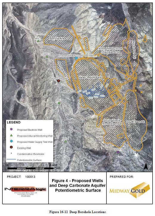
| December 19, 2011 | 112 | |
| Midway Gold Corp. | Mining Methods |
| Pan Gold Project Feasibility Study | NI 43-101 Technical Report |
|
16.1.5.2
|
Water Quality
|
Analytical laboratory results for groundwater samples from condemnation boreholes CDM-6, CDM-3, CDM-33, and CDM-38 indicate that the water quality of the deep aquifer is good, with neutral pH and low total dissolved solids (ranging from 260 to 290 mg/L). Additionally, water from the deep aquifer is warm, with temperatures near 80° Fahrenheit. Concentrations are below the Nevada Profile II reference values, except for concentrations of antimony and thallium for borehole CDM-33 and iron for borehole CDM-3. For borehole CDM-33, antimony and thallium are equal to the reference values of 0.006 mg/L and 0.002 mg/L, respectively.
Air-lift testing was conducted on the seven condemnation boreholes which encountered groundwater. Tests were conducted for several minutes at a purge rate of approximately 30 to 40 gpm. After air-lifting, a pressure transducer was immediately lowered into the borehole to monitor recovery of the water level. By the time the transducer was lowered into the water column, the water level had recovered to static, suggesting that the production potential of the bedrock aquifer is good.
|
16.1.5.3
|
Alluvial Aquifer
|
Shallow, alluvial groundwater has been encountered in wells in the Pan Project vicinity. The closest existing well, identified as the Black Shale Well (also referred to as the Black Shade Well on the USGS Quadrangle map), is located approximately half a mile west of the northwest corner of the proposed leach pad. The State Well Drillers Report indicates that the well was drilled to 66 feet bgs and completed to a depth of 45 feet bgs, with a water level of 32 feet bgs at the time of construction in 1977 (approximately 6,300 feet amsl). This is likely perched groundwater that occurs only along the narrow band of alluvium associated with the unnamed, ephemeral stream west of the project area. Alluvial groundwater also exists in the Newark Valley proper, about five miles west of the Pan Project area. Data from several center-pivot irrigation wells and some historical wells indicate that groundwater in the basin fill ranges from approximately 65 to 127 feet bgs (5,880 to 5,895 feet amsl). These wells are located approximately 5 miles west and northwest of the Pan Project area and are also shown on Figure 16-13.
| December 19, 2011 | 113 | |
| Midway Gold Corp. | Mining Methods |
| Pan Gold Project Feasibility Study | NI 43-101 Technical Report |
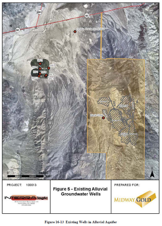
| December 19, 2011 | 114 | |
| Midway Gold Corp. | Mining Methods |
| Pan Gold Project Feasibility Study | NI 43-101 Technical Report |
|
16.1.6
|
Mining Equipment
|
The initial mine production equipment will include a 21.6 yd3 shovel, this unit is a Bucyrus (formerly O&K) RH120E front shovel. A Cat 992 15 yd3 front end loader is also scheduled as a loading unit during the higher stripping phases, this unit will also function as a backup loading unit for the front shovel during lower stripping phases. Initially four Cat 785D 150 ton haul trucks are required to meet the production schedule. During year two of full production an additional 785D will be added to meet production requirements. Two Atlas Copco DM45 drills will also be purchased initially with a third one purchased during year two when the production requirements increase. Tables 16-3 and 16-4 list the initial and additional equipment requirements respectively.
Table 16-3 Initail Mine Equipment
|
Description
|
# Units
|
|
Initial Mine Production Equipment
|
|
|
Rotary Drill 6.75" - 600HP
|
2
|
|
Front Shovel - 21.6 yd3
|
1
|
|
Loader - 15 yd3
|
1
|
|
Rear Dump Trucks - 150 ton
|
4
|
Table 16-4 Additional Mine Equipment
|
Description
|
# Units
|
|
Additional Mine Production Equipment
|
|
|
Rotary Drill 6.75" - 600HP
|
1
|
|
Rear Dump Trucks - 150 ton
|
1
|
|
16.1.7
|
Support Equipment
|
Support equipment will consist of a Cat 834H wheel dozer and a Cat D9 dozer as the main dozing units. The rubber tire dozer was chosen versus two track type dozers for its increased mobility for levelling out the leach pad and waste dumps. A Cat 16M grader will service the haul roads along with a 10,000 gallon water truck. A 1.2 yd3 Cat 320D excavator will be purchased for scaling highwalls and other miscellaneous projects around the mine site. Six mobile light plants will be purchased for lighting the working areas during night time production. A maintenance service truck with a mobile crane will be purchased for field maintenance and a self-contained fuel lube truck will be purchased for infield fuelling. Mine support equipment is summarized in Table 16-5.
| December 19, 2011 | 115 | |
| Midway Gold Corp. | Mining Methods |
| Pan Gold Project Feasibility Study | NI 43-101 Technical Report |
Table 16-5 Mine Support Equipment
|
Description
|
# Units
|
|
Mine Support Equipment
|
|
|
Rubber Tire Dozer - 554HP
|
1
|
|
Dozer - 464HP
|
1
|
|
Graders 16'
|
1
|
|
Water Truck 10,000 gal
|
1
|
|
Maintenance Service Truck & Fuel Lube Truck
|
2
|
|
Excavator - 1.2 yd3
|
1
|
|
Light Plants (10 KW)
|
6
|
|
Pumps 40 HP
|
1
|
|
16.2
|
Preproduction Development
|
The preproduction requirements at Pan are minimal given the presence of mineable ore that outcrops in both the North and South Pan pits. Gustavson has included an allowance for pioneering, clearing, grubbing, and initial haul road construction, and the estimated quantities and costs associated with these tasks are presented in Table 16-6. Clearing and grubbing of the leach pad is included in the leach pad capital cost estimate.

The upper benches at the northern end of the North Pan pit contain a tuffaceous clay material believed to be suitable for use as leach pad under-liner construction material. A total of 150,000 tons of this material is scheduled during preproduction to meet the requirements of the first phase of leach pad construction. The over-liner material, which is a hard silica based ore, will come from the Central Pan pits and from the southern end of the North Pan pit, if necessary. A total of 450,000 tons of this material is scheduled during the first two months of production.
|
16.3
|
Production Schedule
|
The yearly mine production schedule is presented in Table 16-7, with one half years production in year zero. The production schedule is driven by the nominal rate of 17,000 tpd. The production schedule has been calculated on a monthly basis throughout the life of the mine. Yearly peak ore and waste production is estimated at 62,000 tpd, though there are months when the ore and waste production will approach 67,000 tpd.
| December 19, 2011 | 116 | |
| Midway Gold Corp. | Mining Methods |
| Pan Gold Project Feasibility Study | NI 43-101 Technical Report |

|
16.3.1
|
Pit Design Schedule Sequence
|
The Central Pan pits are scheduled for construction first, followed by the Phase 1 South Pan pit, the North Pan pit, and finally the Phase 2 South Pan pit. The Central Pan pits will be backfilled with waste from the Phase 1 South Pan pit to allow for placement of the conveyor from the North Pan pit to the secondary crusher. The option of mining the entire South Pan pit before the North Pan pit was evaluated during the scheduling process. Although the South Pan pit has a 20% higher recovery factor, mining the South Pan in phases results in a higher IRR by delaying the high strip of the Phase 2 South Pit until the end of the mine life. The option of mining the North Pan pit first was also evaluated, but the higher recovery from the South Pan pit (85%, compared to 65% from North Pan) and shorter estimated leach times render the South Pan pit the more favorable option to mine first.
There are times in the production schedule when material is mined from the north pit for construction materials required for the leach pad construction. The phase one under-liner material is scheduled to be mined from the upper benches of the north pit during the pre-production phase. The phase one over-liner material, which is a harder silica ore, is scheduled to come from the central pit. The phase two under-liner and over-liner material will be mined from the north pit. The phase three under-liner and over-liner material will be mined from the north pit during year three; the south pit will still be the main production pit during this year. Leach pad construction materials are presented by tons in Table 16-8.
| December 19, 2011 | 117 | |
| Midway Gold Corp. | Mining Methods |
| Pan Gold Project Feasibility Study | NI 43-101 Technical Report |
Table 16-8 Leach Pad Construction Materials
|
Pad Construction Materials
|
|||||
|
Pad Phase
|
Pad Capacity
|
Under-liner
|
Over-liner
|
||
|
Tons
|
Source
|
Tons
|
Source
|
||
|
Phase I
|
6.5M tons
|
472,181
|
North Pit
|
527,000
|
Central Pit
|
|
Phase II
|
24.8M tons
|
320,000
|
North Pit
|
900,000
|
North Pit
|
|
Phase III
|
36.7M tons
|
340,000
|
North Pit
|
1,080,000
|
North Pit
|
The production schedule by pit is presented in Table 16-9. Stripping of the phase one South pit begins in year zero during the mining of the Central pits. The phase one South pit lasts until the first month of year four with the North pit stripping beginning in the last month of year three. Stripping of the phase two South pit begins at the start of year five with two trucks and the 992 loader slowly stripping at approximately 24,000 tpd for two and a half years while the North pit is the main ore production pit.

|
16.3.2
|
Production Schedule Parameters
|
The mine production schedule is based on a 7 day per week schedule, with two 12 hour shifts per day. There are four crews planned to cover the rotating schedule. Each 12 hour shift contains a half hour down for blasting and miscellaneous delays, a half hour for shift start up and shutdown and a hour for lunch breaks for a total of 10 effective working hours. Each year contains unscheduled time for nine holidays and four non-productive weather shifts. Table 16-10 shows typical monthly schedule parameters and hours scheduled.
| December 19, 2011 | 118 | |
118
| Midway Gold Corp. | Mining Methods |
| Pan Gold Project Feasibility Study | NI 43-101 Technical Report |
Table 16-10 Mine Schedule Parameters
|
Mine Schedule
|
|
|
Crews
|
4
|
|
Shifts/day
|
2
|
|
Hours/shift
|
12 hour
|
|
Lunch, Breaks, etc.
|
1 hour
|
|
Blasting, Misc.
|
0.5 hour
|
|
Startup & Shutdown
|
0.5 hour
|
|
Days/Month
|
31 days
|
|
Less Holidays
|
1 day
|
|
Less Weather and Un-Productive Shifts
|
0
|
|
Scheduled Hours/Month
|
720
|
The amount of equipment required to meet the scheduled tonnages is calculated based on the mine schedule, equipment availabilities, usages and haul and loading times by bench for the equipment. Equipment mechanical physical availabilities start at 93% for the trucks and drills and 92% for the loading units. For each year of production the mechanical physical availabilities decrease by one percent, the use of availability for all of the equipment is calculated at 83% based on the breaks and down time in the schedule parameters. An additional 85% efficiency factor is applied to all of the equipment for calculating the total units of equipment required. Table 16-11 below shows the equipment availability parameters by equipment type.

|
16.3.3
|
Drill and Blast Parameters
|
The design parameters used to define drill and blast requirements are based on a 6.75-inch blast hole on a 14-ft by 16-ft pattern in the ore zones and a 15’ by 17’ pattern in the waste zones. Benches will be blasted and mined on 20-ft levels with 3 ft of sub-drill. Buffer rows and pre-
| December 19, 2011 | 119 | |
| Midway Gold Corp. | Mining Methods |
| Pan Gold Project Feasibility Study | NI 43-101 Technical Report |
shear are planned to allow for controlled blasting and minimize damage to the highwalls. The number of blast holes and blast hole drills required each month is calculated based on the parameters shown in Table 16-12 and used in calculating the operating costs. The majority of the mine life requires two Atlas Copco DM45 drills except for when the average daily total (ore plus waste) production is above 50,000 tpd at which time three drills are required to meet the production schedule.

|
16.3.4
|
Load and Haul Parameters
|
The design parameter used to define the loading and hauling requirements are shown in Table 16-13. The main loading unit is a Bucyrus (formerly O&K) RH120E 21.6 yd3 front shovel with a Cat 992 16 yd3 front end loader as a backup unit. The shovel was chosen over front end
| December 19, 2011 | 120 | |
| Midway Gold Corp. | Mining Methods |
| Pan Gold Project Feasibility Study | NI 43-101 Technical Report |
loaders as the main loading unit because of its higher loading rate versus the loaders which will be advantageous given the short cycle times of the trucks hauling ore to the crusher at the mouth of the pit. Cat 785D 150 ton haul trucks are the main hauling unit, the shovel is calculated to require 5 passes to load the trucks and the loader will require 7 passes. Cat 777 100 ton trucks were also evaluated in the schedule but the 150 ton trucks were found to be more cost effective than the 100 ton trucks. Haulage profiles for the ore and waste material from each pit were generated in FPC to calculate the truck cycle times which were used in the equipment requirement calculations.
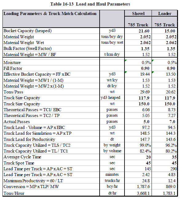
| December 19, 2011 | 121 | |
| Midway Gold Corp. | Recovery Methods |
| Pan Gold Project Feasibility Study | NI 43-101 Technical Report |
|
17
|
RECOVERY METHODS
|
|
17.1.1
|
Process Description
|
Material from the North, Central, and South Pan pits will be processed using conventional heap leaching methods. Ore will be mined and processed first from the Central pit, then the South pit (phase I), from the North pit, and finally from the South pit (phase II).
Ore will be crushed by the primary edge-of-pit mobile jaw crusher and secondary and tertiary cone crushers prior to leaching. Screening at secondary and tertiary crushing stations will control the crush size. The crushed ore will be agglomerated and conveyed to the heap leach pad. Crush size, leach kinetics, and recoveries are based on current metallurgical testing.
|
17.1.2
|
Production Rate and Products
|
The Pan mine and material handling system is designed for a throughput of 17,000 tons of ore per day, or 6.2 million tons of ore per year. The ADR plant is designed at 5,000 gpm, and is expected to produce approximately 80,000 ounces of gold per year. The entire mine and process flow is depicted in Figure 17-1.
| December 19, 2011 | 122 | |
| Midway Gold Corp. | Recovery Methods |
| Pan Gold Project Feasibility Study | NI 43-101 Technical Report |

| December 19, 2011 | 123 | |
| Midway Gold Corp. | Recovery Methods |
| Pan Gold Project Feasibility Study | NI 43-101 Technical Report |
|
17.1.3
|
Primary Crushing
|
Ore will be mined using shovels, loaders, and trucks. The ore will be delivered to the dump bin and grizzly immediately upstream of the primary 38 x 62 jaw crusher (Figure 17-2). The undersize from the grizzly will bypass the crusher and be loaded directly onto the primary ore conveyor. The oversize will be delivered to the jaw crusher and the crushed material will be transferred via a feeder onto the primary ore conveyor, where it will be combined with the bypassed material. The primary overland ore conveyor will deliver material to the primary ore stockpile located next to the secondary/tertiary crushing building.
| December 19, 2011 | 124 | |
| Midway Gold Corp. | Recovery Methods |
| Pan Gold Project Feasibility Study | NI 43-101 Technical Report |
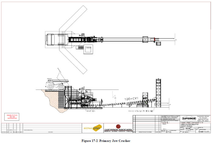
| December 19, 2011 | 125 | |
| Midway Gold Corp. | Recovery Methods |
| Pan Gold Project Feasibility Study | NI 43-101 Technical Report |
The primary crushed ore stockpile will contain a maximum of 20,000 tons of primary crushed ore. The stockpile will be covered with a fabric building and will have 3 live ore feeders, a loader feeder, and a reclaim conveyer which will carry the primary crushed ore to the secondary and tertiary crushing facility.
Equipment components included in the primary crushing, overland conveyor, and stockpile areas are:
|
●
|
Primary Jaw crusher
|
|
●
|
Oil lube pump
|
|
●
|
Rock Box
|
|
●
|
Hydraulic Leveling Jacks (includes 6)
|
|
●
|
Primary Jaw MCC & VSD
|
|
●
|
Rock Breaker
|
|
●
|
Primary Jaw Control House
|
|
●
|
Hydraulic Toggle Assembly
|
|
●
|
48" Heavy Duty Belt Feeder (included above)
|
|
●
|
Jaw crusher transfer conveyor 100-CV-1
|
|
●
|
Ore Overland Conveyor 100-CV 2
|
|
●
|
Tripper incline 200-CV1
|
|
●
|
Tripper Conveyor 200-CV2
|
|
●
|
Loader Belt Feeder 200-LF
|
|
●
|
Feeder Tunnel 200-FT1
|
|
●
|
Tunnel Conveyor 200-CV3
|
|
●
|
Stockpile building
|
|
●
|
Belt Feeders
|
|
17.1.4
|
Secondary Crushing
|
Ore will be crushed and screened at the secondary and tertiary crushing facilities (Figure 17-3). At start-up and during mining of the South Pan pit, the crushing train will consist of a double deck screen and cone crusher capable of reducing the ore size to P80 1½-inch. During mining of the North Pan pit, the crushing train will include an additional screen and a tertiary cone crusher capable of crushing the ore to the finer size of P80 ½-inch.
| December 19, 2011 | 126 | |
| Midway Gold Corp. | Recovery Methods |
| Pan Gold Project Feasibility Study | NI 43-101 Technical Report |
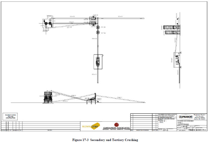
| December 19, 2011 | 127 | |
| Midway Gold Corp. | Recovery Methods |
| Pan Gold Project Feasibility Study | NI 43-101 Technical Report |
Ore smaller than the set limit size will be collected from under the lower screen deck and delivered to the agglomerator by the agglomerator feed conveyor. The secondary and tertiary cone crushers will crush all of the oversized ore to the set size. All ore will be agglomerated and delivered to the leach ore conveyor. The leach ore conveyor will deliver the ore to the edge of the leach pad, where the ore will be transferred onto a chain of mobile conveyors that deliver ore to the mobile radial stacker, which then spreads the ore onto the leach pad.
Equipment components included in conveying and secondary/tertiary crushing are:
|
●
|
Screen Feed Conveyor 300-CV1
|
|
●
|
Screen Tower 300-ST1
|
|
●
|
Screen Discharge Conveyor 300-CV2
|
|
●
|
Surge Bin 300-SB1
|
|
●
|
Transfer Conveyor 300-CV3
|
|
●
|
Crusher Tower 300-CT1
|
|
●
|
Return Conveyor 300-CV4
|
|
●
|
Secondary Cone crusher
|
|
●
|
Tertiary Cone crusher (future)
|
|
●
|
Tertiary Screen (future)
|
|
●
|
Tertiary return conveyors (future)
|
|
●
|
Agglomerator Feed Conveyor 300-CV5
|
|
●
|
Double Deck Screen
|
|
●
|
Tramp Metal Magnet
|
|
17.1.5
|
Agglomeration
|
Cement, lime, and water required for agglomeration will be blended with the ore on the agglomerator feed conveyor (Figure 17-4). The agglomerator will spray water onto the rotating material and agglomerate the fine ore.
| December 19, 2011 | 128 | |
| Midway Gold Corp. | Recovery Methods |
| Pan Gold Project Feasibility Study | NI 43-101 Technical Report |

| December 19, 2011 | 129 | |
| Midway Gold Corp. | Recovery Methods |
| Pan Gold Project Feasibility Study | NI 43-101 Technical Report |
Typical for most Carlin type ores, the reagent consumption is relatively low (Table 17-1). Based on the metallurgical test work, RDI recommended using 0.4 to 0.6 lbs sodium cyanide per ton. 0.50 lbs per ton sodium cyanide consumption at a P80 ½-inch crush size has been used in the economic model.
Table 17-1 Estimated Reagent Consumption
|
LIME
|
1.8 Pounds per ton
|
|
CEMENT
|
5 pounds per ton
|
|
CYANIDE 1 ½” Crush
|
0.27 pounds per ton
|
|
CYANIDE ½” Crush
|
0.50 pounds per ton
|
Tests were completed on both the South and North Pan materials to support these estimates.
Agglomeration equipment includes:
|
●
|
Cement Storage Silo package
|
|
●
|
Lime Storage Silo package
|
|
●
|
Agglomerator Unit
|
|
1.7.1.6
|
Conveying and Stacking
|
Agglomerated ore is delivered to the short overland conveyor, which feeds a series of grasshopper conveyors and ultimately the telestacker conveyor (Figure 17-5). The telestacker conveyor distributes the crushed and agglomerated ore evenly across the leach pad, in 30 foot lifts.
|
●
|
Agglomerator Discharge Conveyor 400-CV1
|
|
●
|
Flat Grade Jump Conveyor 400-JC1-29
|
|
●
|
Feed Conveyor 400-CV3
|
|
●
|
IC Conveyor400-CV4
|
|
●
|
Telestacker Conveyor
|
| December 19, 2011 | 130 | |
| Midway Gold Corp. | Recovery Methods |
| Pan Gold Project Feasibility Study | NI 43-101 Technical Report |
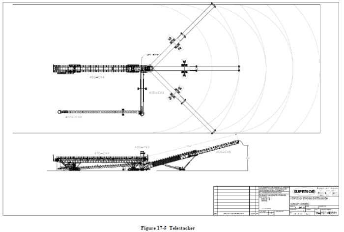
| December 19, 2011 | 131 | |
| Midway Gold Corp. | Recovery Methods |
| Pan Gold Project Feasibility Study | NI 43-101 Technical Report |
|
17.1.7
|
Heap Leach
|
Barren solution will be distributed on the leach pad with drip tube emitters. Pregnant solutions report to the pregnant collection pond, and are subsequently treated in a conventional adsorption/desorption refining (ADR) plant.
|
17.1.8
|
ADR Gold Recovery Plant
|
A general arrangement drawing for the ADR processing facility is shown on Figure 17-6. Summit Valley completed a full set of process flow diagrams and General Arrangement drawings as well as complete engineering drawings and specifications which are included in the Feasibility Study appendices.
The equipment list for the ADR plant is shown in Table 17-2.
| December 19, 2011 | 132 | |
| Midway Gold Corp. | Recovery Methods |
| Pan Gold Project Feasibility Study | NI 43-101 Technical Report |

| December 19, 2011 | 133 | |
| Midway Gold Corp. | Recovery Methods |
| Pan Gold Project Feasibility Study | NI 43-101 Technical Report |

| December 19, 2011 | 134 | |
| Midway Gold Corp. | Project Infrastructure |
| Pan Gold Project Feasibility Study | NI 43-101 Technical Report |
|
18
|
PROJECT INFRASTRUCTURE
|
The Pan project is located within a few miles of an existing high-voltage power line. A major highway (US 50) passes within 6 miles of the project area, water is available on site in adequate quantities, and support for operations personnel and equipment and supplies are available in both Ely and Eureka.
|
18.1
|
Facilities
|
The major buildings planned for the Pan Project include:
|
18.1.1
|
Office Building
|
The office building is a 2-story, 9600-sf building to house the administrative, environmental, and Human Resources staff (Figure 18-1). Building space is allocated for meetings and training.
|
18.1.2
|
Warehouse and Laboratory
|
The warehouse and laboratory will be housed in a 13,050-sf building with a high-bay/low-bay configuration (Figure 18-2). The warehouse will be housed in the high-bay and the laboratory housed in the low-bay. The laboratory will contain sample prep equipment, fire-assay, and solution-assay equipment capable of processing 200 fire-assay samples per day and 100 solution assay samples per day. A fenced-in yard area will be located immediately adjacent to the large overhead doors of the warehouse.
|
18.1.3
|
Truck Shop & Maintenance
|
The truck shop will consist of a 10,500-sf building configured with 2 large bays and a single wash bay with sufficient work space to conduct maintenance on the 150-ton trucks and 992 loaders planned for the project (Figure 18-3). The shop will also house a smaller bay for maintenance of pickups and smaller vehicles.
|
18.1.4
|
Guard House
|
The guard house is a simple, 200-sf security and first aid building, which will be located at the main gate (Figure 18-4).
|
18.1.5
|
Process Building
|
The process building is a 10,800-sf high-bay/low-bay building, with the 30-ft high-bay housing most of the process equipment and the low-bay housing the vault, refinery, and two small offices.
| December 19, 2011 | 135 | |
| Midway Gold Corp. | Project Infrastructure |
| Pan Gold Project Feasibility Study | NI 43-101 Technical Report |
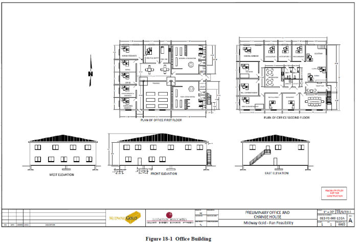
| December 19, 2011 | 136 | |
| Midway Gold Corp. | Project Infrastructure |
| Pan Gold Project Feasibility Study | NI 43-101 Technical Report |
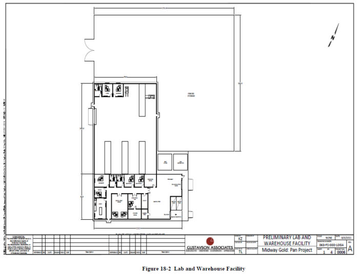
| December 19, 2011 | 137 | |
| Midway Gold Corp. | Project Infrastructure |
| Pan Gold Project Feasibility Study | NI 43-101 Technical Report |
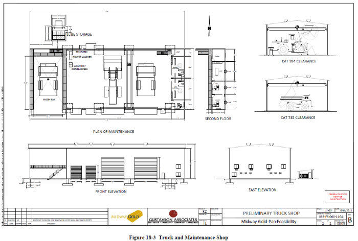
| December 19, 2011 | 138 | |
| Midway Gold Corp. | Project Infrastructure |
| Pan Gold Project Feasibility Study | NI 43-101 Technical Report |
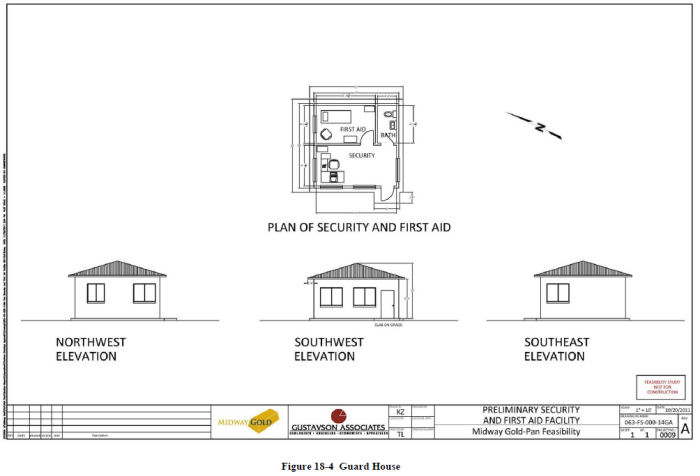
| December 19, 2011 | 139 | |
| Midway Gold Corp. | Project Infrastructure |
| Pan Gold Project Feasibility Study | NI 43-101 Technical Report |
|
18.2
|
Roads
|
The main access road to the mine will originate at US Highway 50, approximately 6 miles from the front gate of the property. The road will be constructed as a gravel embankment. The access road will be built prior to the start of on-site construction and widened prior to the beginning of operations. On-site roads will be constructed to provide for travel between the heap leach pads and the processing plant on the east side of the project area, and to the maintenance shop and crushing facility on the west side. Haul roads will be constructed during the initial development of the pits.
|
18.3
|
Security
|
The guard house at the main gate to the mine site will be manned around the clock. Standard security measures and operating procedures will be established to ensure the security of the site and gold product. The perimeter of the mine site will be fenced with 3-strand barbed wire to keep grazing cattle out. A security chain link fence with a barbed wire top will be installed around the two leach ponds and around the ADR plant.
|
18.4
|
Septic Systems
|
Three septic systems are currently planned on the Pan property: one for the office, one for the warehouse / laboratory, and a third system for the process plant. Portable toilets will be placed at the mining and crushing areas.
|
18.5
|
Water
|
MIDWAY leases water rights sufficient for 800 gpm production in the Pan project area. Drilling was accomplished on site during condemnation drilling, and a well which contacted water at 700+ feet below ground surface was airlift tested. The results indicate that the water meets drinking water standards, and generally has a temperature upwards of 80° F.
Two water wells will be drilled near the gate of the perimeter fence. These wells will be equipped with 250 hp submersible pumps, which will deliver water to the fire water storage tank, the barren leach pond, and the small potable water treatment system. Each well is sized to deliver 800 gpm. Maximum water usage for the Pan Project is summarized in Table 18-1. Although reservoir tests have not yet been completed, regional aquifer production indicates there will be sufficient water for mine development and operations.
| December 19, 2011 | 140 | |
| Midway Gold Corp. | Project Infrastructure |
| Pan Gold Project Feasibility Study | NI 43-101 Technical Report |
Table 18-1 Maximum Water Usage
|
Required Makeup GPM
|
|
|
Leach Pad
|
450
|
|
Roads
|
59
|
|
Conveyor
|
8
|
|
Agglomeration
|
283
|
|
Total
|
800
|
A small water treatment system will be installed to deliver potable water to the office, warehouse, process plant, and truck shop.
Fire water will be supplied to the office, warehouse/laboratory, truck shop, and process plant from a water storage tank located near the gate of the mine. Diesel driven pumps will deliver fire water via underground piping to fire hydrants located next to the various buildings.
|
1.68
|
Power
|
Expected initial power usage (diversified) at the mine and processing plant is approximately 5.6 megawatts. Based on discussions with the power company, Nevada Energy, there is sufficient power available in the local grid to supply the mine and processing plant. A 69 kV line will be built 7.38 miles down Strawberry Road to US 50, where a 69 kV/24.9 kV substation will be installed. The 24.9 kV line will follow the south side of US 50 to the site access road and into the plant substation. Another local mining company will pay for 1/3 of the cost of the 69 kV line and substation. The cost of the 24.9 kV line and site substation will be borne 100% by MIDWAY. Figure 18-5 shows the proposed alignment of the new power line.
| December 19, 2011 | 141 | |
| Midway Gold Corp. | Project Infrastructure |
| Pan Gold Project Feasibility Study | NI 43-101 Technical Report |
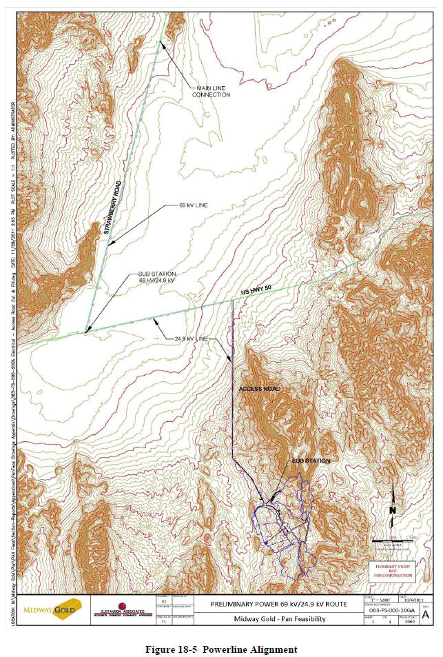
| December 19, 2011 | 142 | |
| Midway Gold Corp. | Project Infrastructure |
| Pan Gold Project Feasibility Study | NI 43-101 Technical Report |
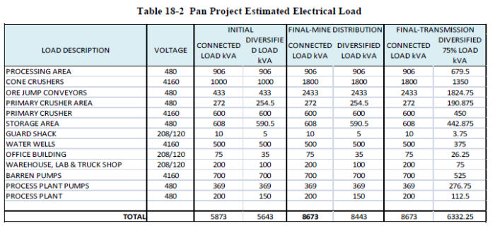
Emergency power will be provided by a generator with sufficient power to run the pregnant leach and barren leach pumps in order to ensure that the leach ponds do not overflow. Minor emergency generator power will be delivered to the process plant to allow for an orderly shutdown in the event of a main supply power failure.
|
18.7
|
Fuel Depot
|
Diesel and gasoline will be purchased in bulk and stored on site at a refueling station. Diesel will be stored in a tank with capacity of 30,000 gal, and a fuel truck will be used to refill the mining equipment. Light duty diesel trucks will refill at the fuel station. Light duty gasoline trucks will similarly refuel at the fuel station on site.
All buildings will be heated with propane delivered from Ely and stored in tanks located on the project site.
|
18.8
|
Communications
|
Current plans call for a microwave-based communication system on site. This system will support internet, VOIP, and data communications necessary for daily operation of the mine, plant, and office.
| December 19, 2011 | 143 | |
| Midway Gold Corp. | Market Studies and Contracts |
| Pan Gold Project Feasibility Study | NI 43-101 Technical Report |
|
19
|
MARKET STUDIES AND CONTRACTS
|
For the economic analysis, the three-year trailing average price of gold was used. This trailing average equated to $1200 per ounce. With gold trading at above $1700 per ounce at the time of preparation of this report, Gustavson feels that the three-year trailing average is an acceptable and conservative pricing to use in the economic analysis.
Gold is a fungible commodity bought and sold universally, and therefore no contracts were negotiated during the Feasibility Study phase of the project. However, it is anticipated that an off-take and smelting agreement will be established with Johnson Matthey or similar organization. Toward that end, discussions with Johnson Matthey were conducted during this study, and the following terms were proposed and were used in the economic analysis:
|
●
|
Treatment Charge: $0.80 per ounce recovered
|
|
●
|
Gold Return: 99.85% of assayed content
|
|
●
|
Silver Return: 97.00% of assayed content
|
|
●
|
Settlement: 15 working days from receipt
|
|
●
|
Pricing: It is assumed that MIDWAY will arrange the pricing and payment with a bank or trading house. If Johnson Matthey is required to provide an early settlement within a few days of receipt, it would cost approx 3% per annum for the number of early days.
|
| December 19, 2011 | 144 | |
| Midway Gold Corp. | Environmental Studies, Permitting and Social or Community Impact |
| Pan Gold Project Feasibility Study | NI 43-101 Technical Report |
|
20
|
ENVIRONMENTAL STUDIES, PERMITTING AND SOCIAL OR COMMUNITY IMPACT
|
|
20.1
|
Permits Required
|
Midway will acquire the permits and authorizations presented in Table 20-1.
Table 20-1 Major Permits and Authorizations Required for Project Development
|
Permit/Approval
|
Granting Agency
|
Permit Purpose
|
|
Federal Permits Approvals and Registrations
|
||
|
Plan of Operations/EIS (Plan of Operations submitted and deemed complete)
|
U.S. Bureau of Land Management
|
Prevent unnecessary or undue degradation associated with Plan of Operations, EIS to disclose environmental impacts and project alternatives. Requires financial assurance. Currently have Plan for exploration with amendment in progress
|
|
Explosives Permit
|
U.S. Bureau of Alcohol, Tobacco & Firearms
|
Storage and use of explosives
|
|
EPA Hazardous Waste ID No.
|
U.S. Environmental Protection Agency
|
Registration as a small-quantity generator of wastes regulated as hazardous
|
|
Notification of Commencement of Operations
|
Mine Safety & Health Administration
|
Mine safety issues, training plan, mine registration
|
|
Nationwide Section 404 Permit
|
U.S. Army Corps of Engineers
|
Installation of any required culverts on the access road.
|
|
Endangered Species Act
|
U.S. Fish and Wildlife Service
|
Only if project affects species listed as threatened or endangered (not anticipated to be necessary)
|
|
Federal Communications Commission
|
FCC
|
Frequency registrations for radio/microwave communication facilities
|
|
State Permits
|
||
|
Air Quality Operating Permit
|
NV Division of Environmental Protection/Bureau of Air Pollution Control
|
Regulates project sources of air emissions. Will require compliance with the new
|
|
Mercury Operating Permit to Construct Air
|
NV Division of Environmental Protection/Bureau of Air Quality Planning/ Nevada Mercury Air Emissions Control Program
|
Requires use of NVMACT for all thermal units that have the potential to emit mercury
|
|
Reclamation Permit
|
NV Division of Environmental Protection/Bureau of Mining Regulation & Reclamation
|
Reclamation of surface disturbance due to mining and mineral processing includes financial assurance requirements. Site currently operates under Reclamation Permit No. 0228.
|
| December 19, 2011 | 145 | |
| Midway Gold Corp. | Environmental Studies, Permitting and Social or Community Impact |
| Pan Gold Project Feasibility Study | NI 43-101 Technical Report |
|
Permit/Approval
|
Granting Agency
|
Permit Purpose
|
|
Water Pollution Control Permit
|
NV Division of Environmental Protection/Bureau of Mining Regulation & Reclamation
|
Prevent degradation of waters of the state from mining, establishes minimum facility design and containment requirements. Site currently operates under WPCP NEV70010.
|
|
Petroleum-Contaminated Soil Management Plan
|
NV Division of Environmental Protection/Bureau of Mining Regulation & Reclamation
|
On-site treatment and management of hydrocarbon-contaminated soils
|
|
Solid Waste Class III Landfill Waiver
|
NV Division of Environmental Protection/Bureau of Solid Waste
|
On-site disposal of non-mining, non-hazardous solid wastes
|
|
General Stormwater Discharge Permit
|
NV Division of Environmental Protection/Bureau of Water Pollution Control
|
Management of site stormwater
|
|
Permit to Appropriate Water
|
NV Division of Water Resources
|
Water appropriation
|
|
Permit to Construct Impoundments
|
NV Division of Water Resources
|
Design and construction of a tailings embankment or other structures with a crest height 20 feet or higher, as measured from the downstream toe to the crest, or that will impound 20 acre-feet or more
|
|
Industrial Artificial Pond Permit
|
NV Department of Wildlife
|
Ponds containing chemicals directly associated with the processing of ore.
|
|
Liquefied Petroleum Gas License
|
NV Board of the Regulation of Liquefied Petroleum Gas
|
Tank specification and installation, handling, and safety requirements
|
|
Potable Water System Permit
|
NV Bureau of Safe Drinking Water
|
Water system for drinking water and other domestic uses (e.g., lavatories)
|
|
Radioactive Materials License
|
NV Bureau of Safe Drinking Water
|
Nuclear flow and mass measurement devices if used in the mineral processing facilities
|
|
Septic Treatment Permit
Sewage Disposal System
|
NV Division of Environmental Protection/Bureau of Water Pollution Control
|
Design, operation, and monitoring of septic and sewage disposal systems
|
|
Hazardous Materials Storage Permit
|
Nevada Fire Marshall
|
Hazardous materials safety
|
|
Local Permits
|
||
|
Building Permits
|
White Pine County Building Planning Department
|
Continued Use
|
|
Conditional Special Use Permit
|
White Pine County Building Planning Department
|
Continued Use
|
|
County Road Use and Maintenance Permit
|
White Pine County Building Planning Department
|
Use and maintenance of county roads
|
| December 19, 2011 | 146 | |
| Midway Gold Corp. | Environmental Studies, Permitting and Social or Community Impact |
| Pan Gold Project Feasibility Study | NI 43-101 Technical Report |
The 2004 Plan of Operations (POO) was submitted on behalf of Castleworth for exploration drilling at the project site, and an Environmental Assessment (EA) was undertaken as part of the permitting process. The EA culminated in a Finding of No Significant Impact (FONSI) and approval to disturb up to 25 acres for drill pads and drill roads. The FONSI was signed in April 2004.
An amendment to the 2004 exploration plan was submitted in 2011 on behalf of Midway, proposing an additional 75 acres of disturbance to construct a new access road, additional drill pads, and spur roads. An EA for that amendment was completed in April 2011 and was approved with a FONSI in August 2011.
Midway has prepared a Mine Plan of Operations (MPO) using the most up-to-date information available. This MPO was deemed to be administratively complete by the BLM in November, 2011. Midway will continue to collect information during drilling and geological exploration activities over the life of the mine, and will amend or revise the MPO as necessary to incorporate new pertinent information. Plans for the first seven years of the 13-year mine life are based on exploration data to date and include leaching simultaneous placement of waste rock waste. Plans for the remaining six years of mine life are based on professional experience and estimates or assumptions of pit dimensions, ore and waste rock volumes, and waste rock characterization.
The MPO proposes to incorporate the authorized exploration disturbance into proposed mining activities. The MPO plan area will encompass the existing exploration area, as well as a mine area which will include:
|
●
|
Two main open pits, the North Pan and the South Pan pits
|
|
●
|
Four satellite pits: the Black Stallion, North Syncline, Syncline, and South Syncline pits
|
|
●
|
Crushing facilities and associated stockpiles
|
|
●
|
Two waste rock disposal sites
|
|
●
|
Heap leach pad, conveyors, processing facilities, and ponds
|
|
●
|
Water supply wells and delivery/storage system
|
|
●
|
Haul and secondary roads
|
The permitting schedule for the Pan Project will be dictated by NEPA process requirements, which typically include at least one year of baseline studies and public review followed by comment periods for scoping and production of draft EIS documents. Completion of an EIS for a new mining project typically requires between 18 and 24 months. With the exception of air permits, the remaining major permits for the project would likely require a NEPA Record of Decision (ROD) prior to permit approval. The air permit process allows a project to be built according to set standards and then an inspection requested, rather than requiring design approval prior to construction. For this reason, preliminary approval of air permits can often be obtained before the NEPA process is complete.
| December 19, 2011 | 147 | |
| Midway Gold Corp. | Capital and Operating Costs |
| Pan Gold Project Feasibility Study | NI 43-101 Technical Report |
|
21
|
CAPITAL AND OPERATING COSTS
|
|
21.1
|
Capital Cost Estimate
|
The capital cost estimate for the Pan Project includes all quoted equipment costs, quoted installation costs, and quantity takeoffs for major components. A breakdown of the total estimated initial capital cost is presented in Table 21-1.
Table 21-1 Pan Project Capital Cost Estimate
|
Feasibility Capital Costs
|
Estimated Cost
|
|||
|
Mine Mobile Equipment
|
$ | 25,614,600 | ||
|
Mine Development
|
$ | 2,000,000 | ||
|
Mine Buildings
|
$ | 1,903,800 | ||
|
Primary Crushing - Edge of Pit to Stockpile
|
$ | 5,604,700 | ||
|
Ore Circuit - From Stockpile to Leach Pad
|
$ | 10,762,800 | ||
|
Gold Recovery Plant
|
$ | 7,290,500 | ||
|
Plant Mobile Equipment
|
$ | 281,600 | ||
|
Leach Pad Installation
|
$ | 6,737,000 | ||
|
Process Ponds
|
$ | 3,623,000 | ||
|
Storm Water Diversion
|
$ | 1,497,200 | ||
|
Infrastructure
|
$ | 13,603,500 | ||
|
Owner's Costs
|
$ | 4,768,800 | ||
|
Reclamation Bond, Facilities
|
$ | 500,000 | ||
|
Subtotal
|
$ | 84,187,500 | ||
|
Contingency
|
$ | 6,765,800 | ||
|
Working Capital
|
$ | 8,214,400 | ||
|
Total Initial Capital
|
$ | 99,167,700 | ||
|
21.1.1
|
Basis
|
The capital cost estimates were generated primarily from quotes from equipment suppliers and contractors. Excluding contingency and working capital, 73% of the estimated costs are from quotes. In-house take-offs and estimated costs from previous construction projects were used for the remaining items. All individual costs include the appropriate sales tax component.
|
21.1.2
|
Mine Development
|
Gustavson has included an allowance for pioneering, clearing, grubbing, and initial haul road construction in the capital cost estimate. The estimated quantities and costs associated with mine development tasks are presented in Table 21-2.
| December 19, 2011 | 148 | |
| Midway Gold Corp. | Capital and Operating Costs |
| Pan Gold Project Feasibility Study | NI 43-101 Technical Report |
Table 21-2 Pan Project Mine Development
|
Description
|
# Units
|
Unit
|
$/Unit
|
Cost
|
|||
|
Mine Development
|
|||||||
|
Pioneering, Clearing and Grubbing
|
1 |
LS
|
$500,000 | $500,000 | |||
|
Haul Road Construction
|
15,000 |
Ft
|
100 | 1,500,000 | |||
|
Total Mine Development Capital
|
$2,000,000 | ||||||
|
21.1.3
|
Mine Equipment
|
Mobile mine equipment requirements were calculated based on haulage cycle times, truck loading parameters, and the required production schedule. Equipment required for the start-up of the mine is listed in Table 21-3. The quotes used for rotary drills are for Atlas Copco DM45’s, the front shovel quote is for a Bucyrus (formerly O&K) RH120E, and the remaining major equipment was quoted by Caterpillar. The quoted equipment includes costs for fire suppression systems.
Table 21-3 Mine Mobile Equipment
|
Description
|
# Units
|
Unit
|
$/Unit
|
Cost
|
||
|
Mine Mobile Equipment
|
||||||
|
Rotary Drill 6.75" - 600HP
|
2 |
Ea
|
$1,023,400 | $2,046,800 | ||
|
Front Shovel - 21.6 yd3
|
1 |
Ea
|
5,444,900 | 5,444,900 | ||
|
Loader - 15 yd3
|
1 |
Ea
|
2,311,300 | 2,311,300 | ||
|
Rear Dump Trucks - 150 ton
|
4 |
Ea
|
2,818,700 | 11,274,800 | ||
|
Rubber Tire Dozer - 554HP
|
1 |
Ea
|
1,095,400 | 1,095,400 | ||
|
Dozer - 464HP
|
1 |
Ea
|
1,053,500 | 1,053,500 | ||
|
Graders 16'
|
1 |
Ea
|
926,700 | 926,700 | ||
|
Water Truck 10,000 gal
|
1 |
Ea
|
940,600 | 940,600 | ||
|
Maintenance Service Truck & Fuel Lube Truck
|
2 |
Ea
|
80,600 | 161,200 | ||
|
Excavator - 1.2 yd3
|
1 |
Ea
|
211,800 | 211,800 | ||
|
Light Plants (10 KW)
|
6 |
Ea
|
23,700 | 142,200 | ||
|
Pumps 40 HP
|
1 |
Ea
|
5,400 | 5,400 | ||
|
Total Mining Mobile Equipment Capital
|
$25,614,600 | |||||
|
21.1.4
|
Mine Buildings
|
The buildings and infrastructure required for the mine department will consist of 10,500 sf truck shop and a fuelling station. The mine dry will be included inside of the administration building. The mine maintenance shop will consist of two large bays for equipment repairs, a large equipment wash bay, and two smaller bays for light vehicles. Mine building details are summarized in Table 21-4.
| December 19, 2011 | 149 | |
| Midway Gold Corp. | Capital and Operating Costs |
| Pan Gold Project Feasibility Study | NI 43-101 Technical Report |
|
Description
|
# Units
|
Unit
|
$/Unit
|
Cost
|
||||
|
Fuel Station
|
1 |
LS
|
107,500 | 107,500 | ||||
|
Total Mine Buildings Capital
|
$1,903,800 | |||||||
|
21.1.5
|
Facilities and Infrastructure
|
The major facilities planned for the Pan Project include:
|
●
|
Office building– 2 story, 9600 sf
|
|
●
|
Warehouse / Laboratory – 13,050 sf
|
|
●
|
Truck shop– 10,500 sf
|
|
●
|
Guard house – 200 sf
|
|
●
|
Process building – high bay / low bay, total 10,800 sf
|
The capital cost associated with the Process Building is included in the capital cost estimated for the gold recovery process.
The water system at Pan will consist of two production wells, a 180,000 gallon storage tank, delivery pipelines, a fire water diesel-driven pump loop, and fire hydrants.
Power supply installation costs will include 2/3 of the cost of construction of a 69 kV line over a distance of 7.38 miles along Strawberry Road to US 50, where a 69 kV/24.9 kV substation will be installed, plus the cost of a 24.9 kV line from the substation to the Pan Project site. MIDWAY will pay for 2/3 of the cost of the 69 kV line and substation, and another local mining company will pay for the other 1/3 of the cost. The estimate for equipment and installation was prepared by Hanlon Engineering. The capital cost for site power distribution was developed by Electrical Consultants Inc. (ECI) from one-line diagrams and quotes on transformers and motor control centers. The estimated capital cost for installation of on-site power distribution is $3,652,300.
The main access road will include 5.78 miles of new gravel surface. The road will be built prior to the start of construction and expanded during construction. An estimated construction cost of $1,788,000 was included for the cost of expanding the road. On-site roads are expected to require approximately 2.3 miles of new construction, at a cost of $147,688 per mile, for a total of $339,700.
Diesel and gas storage will consist of two tanks, delivery pumps, and a containment berm. Propane will be used to heat the office, the warehouse/laboratory, the guard house, truck shop,
| December 19, 2011 | 150 | |
| Midway Gold Corp. | Capital and Operating Costs |
| Pan Gold Project Feasibility Study | NI 43-101 Technical Report |
and the process building. Propane tanks will be installed at each location, and the tanks and associated piping and valves have been included in the capital cost estimate.
Three separate septic systems are planned for the Pan Project. One system will support the office building, one system will support both the truck shop and warehouse complex, and one system will support the process building area. Portable toilets will be used in the mining area.
The perimeter of the mine site will be fenced with 3-strand barbed wire to keep grazing cattle out. A security chain link fence with a barbed wire top will be installed around the two leach ponds and around the ADR plant.
The capital costs associated with infrastructure, facilities, and buildings are summarized in Table 21-5.
| December 19, 2011 | 151 | |
| Midway Gold Corp. | Capital and Operating Costs |
| Pan Gold Project Feasibility Study | NI 43-101 Technical Report |
Table 21-5 Pan Project Infrastructure, Facilities, and Buildings
|
Description
|
# Units
|
Unit
|
$/Unit
|
Cost
|
||||||||
|
Infrastructure
|
||||||||||||
|
Wells
|
1 |
Ea
|
$ | 110,000 | $ | 110,000 | ||||||
|
Pumps
|
2 |
Ea
|
21,500 | 43,000 | ||||||||
|
Piping, includes installation
|
3,000 |
ft
|
14.81 | 44,400 | ||||||||
|
Piping installation
|
0 |
Day
|
1,620 | 0 | ||||||||
|
Pressure Tank
|
1 |
Ea
|
16,100 | 16,100 | ||||||||
|
Fire Water Storage Tank on site
|
1 |
Ea
|
283,300 | 283,300 | ||||||||
|
Fire Loop Piping & Equipment
|
1 |
Ea
|
367,100 | 367,100 | ||||||||
|
Electrical / Controls
|
1 |
Ea
|
10,800 | 10,800 | ||||||||
|
Installation
|
1 |
Ea
|
50,000 | 50,000 | ||||||||
|
69 KV line
|
38,966 |
ft
|
31.59 | 1,230,900 | ||||||||
|
24.9 KV line
|
48,998 |
ft
|
28.84 | 1,413,100 | ||||||||
|
Substation (69/25)
|
1 |
Lot
|
537,500 | 537,500 | ||||||||
|
Substation (25/480)
|
1 |
Lot
|
161,300 | 161,300 | ||||||||
|
Emergency Generator
|
1 |
Lot
|
118,300 | 118,300 | ||||||||
|
Site Power Distribution
|
1 |
Lot
|
3,652,300 | 3,652,300 | ||||||||
|
Main Road access
|
5.78 |
Miles
|
309,343 | 1,788,000 | ||||||||
|
On-Site Road Construction
|
2.3 |
Miles
|
147,688 | 339,700 | ||||||||
|
Propane Tank & piping
|
1 |
Ea
|
51,500 | 51,500 | ||||||||
|
Communications
|
1 |
Ea
|
118,500 | 118,500 | ||||||||
|
Warehouse/Laboratory
|
16,500 |
sf
|
85.40 | 1,409,100 | ||||||||
|
Equipment/Furnishings
|
1 |
Lot
|
53,800 | 53,800 | ||||||||
|
Plant Air Systems
|
1 |
LS
|
53,800 | 53,800 | ||||||||
|
Office
|
5,000 |
sf
|
209.50 | 1,047,500 | ||||||||
|
Laboratory Equipment
|
1 |
LS
|
458,400 | 458,400 | ||||||||
|
Sewage System
|
1 |
LS
|
46,400 | 46,400 | ||||||||
|
Guard House / Security Facility
|
1 |
LS
|
51,500 | 51,500 | ||||||||
|
First Aid Facility
|
1 |
LS
|
25,800 | 25,800 | ||||||||
|
Security Fencing
|
1 |
LS
|
51,500 | 51,500 | ||||||||
|
Diff GPS - Survey
|
1 |
LS
|
69,900 | 69,900 | ||||||||
|
Total Infrastructure Capital
|
$ | 13,603,500 | ||||||||||
|
21.1.6
|
Primary Crushing and Coarse Ore Storage
|
The feasibility analysis for the Pan Project assumes that a Lippman model 3862 Mobile Jaw crusher will be used for primary crushing. Installation will include the 38-inch by 62-inch jaw crusher, a rock-box dump box, a 62-inch by 28-inch vibrating grizzly, feeders and conveyors to
| December 19, 2011 | 152 | |
| Midway Gold Corp. | Capital and Operating Costs |
| Pan Gold Project Feasibility Study | NI 43-101 Technical Report |
deliver the crushed and bypass material to a transfer conveyor, a rock breaker, and a control house. The transfer conveyor moves the crushed material to the 2,798-foot overland conveyor, which delivers crushed ore to the stockpile. The coarse ore from the overland conveyor is delivered to a tripper conveyor, which lifts the ore into the stockpile building and unloads onto the stockpile. The stockpile has both live and dead storage, and is contained in a “clear span” building. The live storage ore is delivered to pan feeders through three separate chutes. The pan feeders feed the takeaway conveyor, which delivers the ore to the secondary crushing area.
The total capital cost for equipment associated with the primary crushing and coarse ore storage material handling area is summarized in Table 21-6.
Table 21-6 Primary Crushing and Material Handling
|
Description
|
# Units
|
Unit
|
$/Unit
|
Cost
|
||||||||
|
Primary Crushing - Edge of Pit to Stockpile
|
||||||||||||
|
Jaw primary
|
1 |
Ea
|
$ | 1,014,500 | $ | 1,014,500 | ||||||
|
Oil lube pump, included in Jaw cost
|
1 |
Ea
|
0 | 0 | ||||||||
|
VGF included above
|
1 |
Ea
|
0 | 0 | ||||||||
|
Rock Box
|
1 |
Ea
|
537,500 | 537,500 | ||||||||
|
Hydraulic Leveling Jacks (includes 6)
|
1 |
Ea
|
40,300 | 40,300 | ||||||||
|
Primary Jaw MCC &VSD
|
1 |
Ea
|
52,800 | 52,800 | ||||||||
|
Rock Breaker
|
1 |
Ea
|
215,000 | 215,000 | ||||||||
|
Primary Jaw Control House
|
1 |
Ea
|
107,500 | 107,500 | ||||||||
|
Hydraulic Toggle Assembly
|
1 |
Ea
|
69,900 | 69,900 | ||||||||
|
Jaw Crusher Transfer Conveyor 100-CV 2
|
1 |
Ea
|
224,300 | 224,300 | ||||||||
|
Ore Overland Conveyor 100-CV 2
|
1 |
Ea
|
1,581,400 | 1,581,400 | ||||||||
|
Tripper Incline 200-CV 1
|
1 |
Ea
|
307,500 | 307,500 | ||||||||
|
Tripper Conveyor 200-CV 2
|
1 |
Ea
|
385,300 | 385,300 | ||||||||
|
Loader Belt Feeder 200-LF
|
1 |
Ea
|
137,200 | 137,200 | ||||||||
|
Feeder Tunnel 200-FT
|
1 |
Ea
|
129,700 | 129,700 | ||||||||
|
Tunnel Conveyor 200-CV 3
|
1 |
Ea
|
264,400 | 264,400 | ||||||||
|
Stockpile Building
|
1 |
Ea
|
361,600 | 361,600 | ||||||||
|
Belt Feeders
|
3 |
Ea
|
58,600 | 175,800 | ||||||||
|
Total Mining Material Handling Capital
|
$ | 5,604,700 | ||||||||||
|
21.1.7
|
Secondary Crushing, Agglomeration and Stacking
|
Secondary crushing will begin with production from the South Pan pit, and will consist of screening and crushing to further reduce the ore from nominal 12-inch size to 80% passing 1.5-inches. The secondary crushed ore is fed through an agglomerator and onto the short overland conveyor, where it is delivered to a string of grasshopper conveyors. The grasshopper conveyors then deliver the ore to the telestacker on the leach pad. The capital cost of equipment required for the secondary crushing facility, agglomerator, and stacking area is shown in Table 21-7.
| December 19, 2011 | 153 | |
| Midway Gold Corp. | Capital and Operating Costs |
| Pan Gold Project Feasibility Study | NI 43-101 Technical Report |
Table 21-7 Secondary Crushing and Stacking
|
Description
|
# Units
|
Unit
|
$/Unit
|
Cost
|
||||||||
|
Ore Circuit - From Stockpile to Leach Pad
|
||||||||||||
|
Screen Feed Conveyor 300-CV 1
|
1 |
Ea
|
$ | 246,000 | $ | 246,000 | ||||||
|
Screen Tower 300-ST 1
|
1 |
Ea
|
46,800 | 46,800 | ||||||||
|
Screen Discharge Conveyor 300-CV 2
|
1 |
Ea
|
273,900 | 273,900 | ||||||||
|
Surge Bin 300-SB 1
|
1 |
Ea
|
144,400 | 144,400 | ||||||||
|
Transfer Conveyor 300-CV 3
|
1 |
Ea
|
57,700 | 57,700 | ||||||||
|
Crusher Tower 300-CT 1
|
1 |
Ea
|
52,100 | 52,100 | ||||||||
|
Return Conveyor 300-CV 4
|
1 |
Ea
|
251,500 | 251,500 | ||||||||
|
Secondary Cone Crusher
|
1 |
Ea
|
2,088,300 | 2,088,300 | ||||||||
|
Agglomerator Feed Conveyor 300-CV 2
|
1 |
Ea
|
186,400 | 186,400 | ||||||||
|
Double Deck Screen
|
2 |
Ea
|
244,800 | 489,600 | ||||||||
|
Belt Metal Detector, 54"
|
1 |
Ea
|
13,400 | 13,400 | ||||||||
|
Belt Weigh Scale, 48"
|
1 |
Ea
|
15,300 | 15,300 | ||||||||
|
Cement Storage Silo package
|
1 |
Ea
|
179,300 | 179,300 | ||||||||
|
Lime Storage Silo package
|
1 |
Ea
|
226,500 | 226,500 | ||||||||
|
Agglomerator Discharge Conveyor 400
|
1 |
Ea
|
143,300 | 143,300 | ||||||||
|
Flat Grade Jump Conveyor 400-CJ 1
|
26 |
Ea
|
57,900 | 1,505,400 | ||||||||
|
Feed Conveyor 400-CV 3
|
1 |
Ea
|
62,800 | 62,800 | ||||||||
|
Telestacker Conveyor
|
1 |
Ea
|
496,200 | 496,200 | ||||||||
|
Concrete Installation
|
3920 |
CuYd
|
248.29 | 973,300 | ||||||||
|
Installation of Crusher and Conveyor
|
1 |
Ea
|
1,311,000 | 1,311,000 | ||||||||
|
Allen Bradley Control System
|
1 |
Ea
|
225,800 | 225,800 | ||||||||
|
Agglomerator Unit – Skid- Mounted
|
1 |
Ea
|
1,773,800 | 1,773,800 | ||||||||
|
Total Process Material Handling Capital
|
$ | 10,762,800 | ||||||||||
When production switches to the North pit a tertiary crusher will be added to the secondary circuit to crush the North ores to 0.5 in. Table 21-8 lists the costs associated with installing the tertiary crusher and associated infrastructure and relocating the primary crushing circuit from the South pit to the North pit.
| December 19, 2011 | 154 | |
| Midway Gold Corp. | Capital and Operating Costs |
| Pan Gold Project Feasibility Study | NI 43-101 Technical Report |
Table 21-8 Secondary Tertiary Crusher
|
Description
|
# Units
|
Unit
|
$/Unit
|
Cost
|
||||||||
|
Tertiary Crusher & Ancillary Facilities
|
||||||||||||
|
Crusher Tower 300-CT 1
|
1 |
Ea
|
$ | 52,100 | $ | 52,100 | ||||||
|
Return Conveyor 300-CV 4
|
1 |
Ea
|
251,500 | 251,500 | ||||||||
|
|
1 |
Ea
|
2,088,300 | 2,088,300 | ||||||||
|
Install Crusher
|
1 |
Ea
|
357,000 | 357,000 | ||||||||
|
Retaining Wall for Primary - North Pit
|
1 |
Ea
|
238,000 | 238,000 | ||||||||
|
Relocate and Install Conveyor to North Pit
|
1 |
Ea
|
178,000 | 178,000 | ||||||||
|
Total Tertiary Crusher & Ancillary Facilities
|
$ | 3,164,900 | ||||||||||
|
21.1.8
|
Leaching
|
Leach pads were designed and the associated costs estimated by SRK with input from Gustavson. Sufficient leach pad area (2.5 million square feet) was included in the initial capital cost for the first 17 months of operation. Expansion of the leach pad is planned during the first summer of operation, and again after year 3, to attain the ultimate leach pad size of 12.8 million square feet. Leach pad capital costs are summarized in Table 21-9.
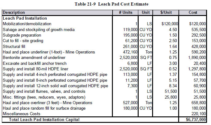
|
21.1.9
|
Process Ponds
|
Capital costs for the process ponds were estimated for the final pond capacity, and include sufficient volume for the maximum leaching capacity of 5000 gpm. Allowance for runoff
| December 19, 2011 | 155 | |
| Midway Gold Corp. | Capital and Operating Costs |
| Pan Gold Project Feasibility Study | NI 43-101 Technical Report |
containment is included in the design. Capital costs associated with the process ponds are presented in Table 21-10.
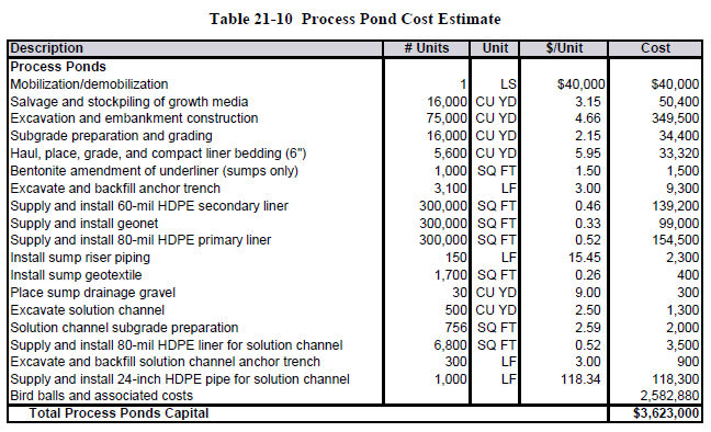
|
21.1.10
|
Storm Water Diversions
|
SRK’s design for storm water diversions is based on the 100-year, 24-hour storm event. The diversions will be built to exist for the life of the mine. The estimated costs for the storm water diversions are presented in Table 21-11.

|
21.1.11
|
Gold Recovery
|
Gold recovery facilities at Pan include an ADR plant, gold refinery, and vault. Summit Valley and WGC Group prepared the capital supply and installation cost for the ADR plant and
| December 19, 2011 | 156 | |
| Midway Gold Corp. | Capital and Operating Costs |
| Pan Gold Project Feasibility Study | NI 43-101 Technical Report |
building. An identical plant was designed, built, and installed by Summit Valley and WGC, and the completed engineering and capital cost estimate presented here is based on the previous installation, updated to today’s dollars. The total gold recovery process area capital cost is shown in Table 21-12.
Table 21-12 Gold Recovery Process
|
Description
|
# Units
|
Unit
|
$/Unit
|
Cost
|
||||||||
|
Gold Recovery Plant
|
||||||||||||
|
Carbon Col - 14.5' dia, w/ pumps - 5000 gpm
|
5 |
ea
|
$ | 245,900 | $ | 1,229,500 | ||||||
|
Acid Wash (stainless steel)
|
1 |
ea
|
148,600 | 148,600 | ||||||||
|
Stripping Circuit - 200 lb
|
1 |
ea
|
120,700 | 120,700 | ||||||||
|
Heater Skid
|
1 |
ea
|
277,400 | 277,400 | ||||||||
|
Electrowinning
|
1 |
ea
|
382,200 | 382,200 | ||||||||
|
Carbon Handling
|
1 |
ea
|
197,100 | 197,100 | ||||||||
|
Carbon Regeneration
|
1 |
ea
|
536,100 | 536,100 | ||||||||
|
Refinery
|
1 |
ea
|
456,700 | 456,700 | ||||||||
|
Reagents Handling
|
1 |
ea
|
155,000 | 155,000 | ||||||||
|
Piping and Valves
|
1 |
lot
|
304,600 | 304,600 | ||||||||
|
Electrical
|
1 |
lot
|
327,200 | 327,200 | ||||||||
|
Engineering
|
1 |
lot
|
387,200 | 387,200 | ||||||||
|
Data Logging System
|
1 |
ea
|
68,500 | 68,500 | ||||||||
|
Freight
|
1 |
lot
|
165,400 | 165,400 | ||||||||
|
Spare Parts See First Fills
|
1 |
lot
|
200,000 | 0 | ||||||||
|
Construction Management
|
1 |
lot
|
216,000 | 216,000 | ||||||||
|
Installation
|
1 |
lot
|
1,560,000 | 1,560,000 | ||||||||
|
Startup Assistance
|
1 |
lot
|
54,000 | 54,000 | ||||||||
|
Process Plant Leak Detection
|
1 |
ea
|
74,200 | 74,200 | ||||||||
|
Building
|
1 |
ea
|
630,100 | 630,100 | ||||||||
|
Total Process Material Handling Capital
|
$ | 7,290,500 | ||||||||||
The mobile equipment requirements for the plant are listed in Table 21-13. The pickups for the plant are included in the administration capital.
| December 19, 2011 | 157 | |
| Midway Gold Corp. | Capital and Operating Costs |
| Pan Gold Project Feasibility Study | NI 43-101 Technical Report |
Table 21-13 Plant Mobile Equipment
|
Description
|
# Units
|
Unit
|
$/Unit
|
Cost
|
||||||||
|
Plant Mobile Equipment
|
||||||||||||
|
Backhoe, with Front End Loader
|
1 |
ea
|
$ | 117,100 | $ | 117,100 | ||||||
|
Crane, 35 ton
|
1 |
ea
|
$ | 107,500 | $ | 107,500 | ||||||
|
Flatbed truck
|
1 |
ea
|
$ | 57,000 | $ | 57,000 | ||||||
|
Total Plant Mobile Equipment Capital
|
$ | 281,600 | ||||||||||
|
21.1.12
|
Owner’s Costs
|
As with any project, there are costs that are borne by the owner (MIDWAY) which are separate and distinct from the cost of construction and installation. The estimated owner’s costs for the Pan Project are based in part on previous projects where the owner’s costs were uniquely identified and tracked. The identified costs include items such as computers, office equipment and supplies, training costs, owner’s staff costs during construction and startup, consulting costs, the cost of vendors’ representatives, recruitment, safety supplies, and on-site office costs. Estimated owner’s costs are presented in Table 21-14.
| December 19, 2011 | 158 | |
| Midway Gold Corp. | Capital and Operating Costs |
| Pan Gold Project Feasibility Study | NI 43-101 Technical Report |
Table 21-14 Owner’s Costs
|
Description
|
# Units
|
Unit
|
$/Unit
|
Cost
|
||||||||
|
Construction Phase Projects
|
||||||||||||
|
Construction Contractors Mob/Demob
|
1 | $ | 127,000 | $ | 127,000 | |||||||
|
Diesel Fuel Purchases
|
1 | 35,000 | 35,000 | |||||||||
|
Electric Power Purchases
|
1 | 100,000 | 100,000 | |||||||||
|
Potable Water Purchases
|
1 | 16,100 | 16,100 | |||||||||
|
Computers
|
1 | 154,300 | 154,300 | |||||||||
|
Site Laboratory Operation - in capital period
|
1 | 171,000 | 171,000 | |||||||||
|
Safety Supplies
|
1 | 164,500 | 164,500 | |||||||||
|
Mine Training, incl Salaries Wages
|
1 | 433,700 | 433,700 | |||||||||
|
Site Environmental Training Programs
|
1 | 25,800 | 25,800 | |||||||||
|
Site Environmental Costs - in capital period
|
1 | 80,900 | 80,900 | |||||||||
|
Site Safety/Security Costs - in capital period
|
1 | 48,200 | 48,200 | |||||||||
|
Site G&A Operating Costs - in capital period
|
1 | 220,500 | 220,500 | |||||||||
|
Pickups for Mine, Plant, G&A
|
16 | 32,300 | 516,800 | |||||||||
|
Emergency Vehicle
|
1 | 69,900 | 69,900 | |||||||||
|
Miscellaneous Construction Materials Purchase
|
1 | 32,300 | 32,300 | |||||||||
|
Small Tools Purchases
|
1 | 96,800 | 96,800 | |||||||||
|
Travel/Housing/Accommodations
|
1 | 142,000 | 142,000 | |||||||||
|
Recruitment
|
1 | 75,000 | 75,000 | |||||||||
|
Vendor Rep Services and Equipment Testing
|
1 | 160,000 | 160,000 | |||||||||
|
Site Construction Insurance
|
1 | 160,000 | 160,000 | |||||||||
|
Engineering - Buildings
|
1 | 429,000 | 429,000 | |||||||||
|
Engineering - Mining
|
1 | 400,000 | 400,000 | |||||||||
|
Consulting Costs - Construction Management
|
1 | 396,000 | 396,000 | |||||||||
|
Consulting Costs - Geotechnical/Environmental
|
1 | 264,000 | 264,000 | |||||||||
|
Consulting Costs - Other
|
1 | 315,000 | 315,000 | |||||||||
|
Project Construction QA/QC
|
1 | 135,000 | 135,000 | |||||||||
|
Total Owner's Construction Phase Projects
|
$ | 4,768,800 | ||||||||||
|
21.1.13
|
EPCM
|
Engineering, procurement, and construction costs are included in the capital cost estimates described in the individual sections above.
|
21.1.14
|
Working Capital
|
Working capital is estimated for the first 2 months of operation in conjunction with first fills and consumable supplies. Estimated working capital costs are shown in Table 21-15.
| December 19, 2011 | 159 | |
| Midway Gold Corp. | Capital and Operating Costs |
| Pan Gold Project Feasibility Study | NI 43-101 Technical Report |
Table 21-15 Working Capital Costs
|
FIRST FILLS
|
tons
|
gallons
|
pounds
|
$/unit
|
extension
|
||||||||||||||
|
Lime
|
50 | 100,000 | $ | 0.099 | $ | 9,900 | |||||||||||||
|
Cyanide
|
20 | 40,000 | $ | 1.30 | $ | 52,000 | |||||||||||||
|
Cement
|
50 | 100,000 | $ | 0.071 | $ | 7,100 | |||||||||||||
|
Diesel
|
10,000 | $ | 3.00 | $ | 30,000 | ||||||||||||||
|
Gasoline
|
1,000 | $ | 3.00 | $ | 3,000 | ||||||||||||||
|
Carbon
|
50 | 100,000 | $ | 1.15 | $ | 115,000 | |||||||||||||
|
Other
|
$ | 16,000 | |||||||||||||||||
|
ANFO
|
40 | 80,000 | $ | 0.30 | $ | 24,000 | |||||||||||||
|
Caps
|
1000 | $ | 3.00 | $ | 3,000 | ||||||||||||||
|
Boosters
|
1000 | $ | 4.58 | $ | 4,580 | ||||||||||||||
|
Tires
|
$ | 100,000 | |||||||||||||||||
|
Warehouse Supplies
|
$ | 1,100,000 | |||||||||||||||||
|
Subtotal- First Fills and Consumables
|
$ | 1,464,580 | |||||||||||||||||
|
Working Capital - 2 months of operating costs
|
$ | 6,749,869 | |||||||||||||||||
|
Total Operating Capital
|
$ | 8,214,449 | |||||||||||||||||
|
21.1.15
|
Sustaining Capital
|
Table 21-16 lists additional mine equipment that will be required to meet production requirements during year 2 of the schedule, as the total tons mined increases above 50,000 tpd.
Table 21-16 Additional Mine Equipment
|
Description
|
# Units
|
Unit
|
$/Unit
|
Cost
|
||||||||
|
Additional Mine Mobile Equipment
|
||||||||||||
|
Rotary Drill 8 inch 475HP
|
1 |
Ea
|
$ | 1,023,400 | $ | 1,023,400 | ||||||
|
Rear Dump Trucks - 150 ton (785)
|
1 |
Ea
|
2,818,700 | 2,818,700 | ||||||||
|
Total Additional Mine Mobile Equipment
|
$ | 3,842,100 | ||||||||||
Sustaining Capital was calculated based on major rebuild items whose costs are capitalized and removed from operating costs. The sustaining capital is based on each individual piece of equipment’s cumulative operating hours, and an hourly rate for replacing the component. The hourly rates were derived from previous project experience and/or the Mine and Mill cost handbook published by InfoMine. Since the equipment is new and will be under warranty for at least the first twelve months, the component costs don’t start accruing until 7,500 hours of operation are cumulated. The sustaining capital costs are also not accrued for the last twelve months of operation, as the major components will not be changed out. Table 21-17 summarizes the sustaining capital cost for scheduled major mining equipment rebuilds.
| December 19, 2011 | 160 | |
| Midway Gold Corp. | Capital and Operating Costs |
| Pan Gold Project Feasibility Study | NI 43-101 Technical Report |
Table 21-17 Mine Sustaining Capital Major Rebuilds
|
Department
|
Year 0
|
Year 1
|
Year 2
|
Year 3
|
Year 4
|
Year 5
|
Year 6
|
Year 7
|
Year 8
|
|||||||||
|
Mine G&A
|
- | 20,453 | 52,296 | 111,689 | 120,989 | 122,910 | 122,643 | 101,540 | - | |||||||||
|
Drilling
|
- | 91,840 | 172,257 | 153,403 | 158,443 | 173,011 | 173,588 | 138,008 | - | |||||||||
|
Haulage
|
- | 304,978 | 850,410 | 738,702 | 674,666 | 922,618 | 943,529 | 780,836 | - | |||||||||
|
Loading
|
- | 129,570 | 311,121 | 315,865 | 336,802 | 491,476 | 563,371 | 334,007 | - | |||||||||
|
Roads & Dumps
|
- | 106,161 | 398,889 | 398,559 | 400,576 | 405,434 | 404,973 | 338,905 | - | |||||||||
|
Grand Total
|
- | 653,002 | 1,784,973 | 1,718,218 | 1,691,476 | 2,115,449 | 2,208,104 | 1,693,296 | - | |||||||||
|
21.1.16
|
Contingency
|
Contingency was developed using a Monte Carlo simulation approach. Each capital cost item was reviewed to determine its likely low cost and likely high cost. This range of capital costs was then built into a simulation using Crystal Ball software, and 10,000 iterations of the estimate were run. The resulting graph, Figure 21-1, was then used to determine the appropriate level of contingency based upon a 90% confidence level. A contingency level of 8% was included as a result of this analysis.

| December 19, 2011 | 161 | |
| Midway Gold Corp. | Capital and Operating Costs |
| Pan Gold Project Feasibility Study | NI 43-101 Technical Report |
|
21.2
|
Operating Cost Estimate
|
|
21.2.1
|
Project Cost and Basis
|
The Pan Project’s cash operating costs are estimated to be $6.54 per ton of ore processed including mining, processing, general and administrative, net proceeds of mines taxes, property taxes and a 5% contingency on operating costs. The unit costs summarized in Tables 21-18 and 21-19 are based on annual ore production of 6,205,000 tons (17,000 t/d) and 365 days of operation.
Table 21-18 Pan Operating Cost Summary by Cost Type
|
Operating Cost
|
Life of Mine
Cost
|
Average
Annual cost
|
Cost/
ton ore
|
Cost/
ton
mined
|
Cost/
oz Au
Produced
|
|
|
Mine - Open Pit
|
||||||
|
Production Equipment - Cost
|
$52,501,000
|
$6,054,600
|
$0.99
|
$0.35
|
$80.91
|
|
|
Support Equipment - Cost
|
10,960,000
|
1,263,900
|
0.21
|
0.07
|
16.89
|
|
|
Materials/Other Requirements
|
27,168,000
|
3,133,100
|
0.51
|
0.18
|
41.87
|
|
|
Hourly Personnel
|
45,702,000
|
5,270,600
|
0.86
|
0.31
|
70.43
|
|
|
Salaried Personnel
|
11,589,000
|
1,336,500
|
0.22
|
0.08
|
17.86
|
|
|
Total Mining
|
$147,920,000
|
$17,058,700
|
$2.78
|
$1.00
|
$227.97
|
|
|
Processing Plant
|
||||||
|
Reagents
|
$66,591,000
|
$7,679,500
|
$1.25
|
$102.63
|
||
|
Other operating costs
|
31,194,000
|
3,597,400
|
0.59
|
48.07
|
||
|
Energy
|
6,593,000
|
760,400
|
0.12
|
10.16
|
||
|
Hourly Personnel
|
24,600,000
|
2,837,000
|
0.46
|
37.91
|
||
|
Salaried Personnel
|
8,465,000
|
976,300
|
0.16
|
13.05
|
||
|
Total Processing
|
$137,443,000
|
$15,850,600
|
$2.58
|
$211.82
|
||
|
General & Administrative
|
||||||
|
General Management
|
$12,634,000
|
$1,457,100
|
$0.24
|
$19.47
|
||
|
Services and Supplies
|
7,147,000
|
824,200
|
0.13
|
11.01
|
||
|
Total General & Administrative
|
$19,781,000
|
$2,281,300
|
$0.37
|
$30.49
|
||
|
Net Proceeds of Mines/Property Tax
|
$27,892,000
|
$3,216,600
|
$0.52
|
$42.99
|
||
|
Operating Cost - Contingency 5%
|
$15,257,000
|
$1,759,500
|
$0.29
|
$23.51
|
||
|
Total Operating Cost
|
$348,293,000
|
$40,166,700
|
$6.54
|
$536.78
|
||
| December 19, 2011 | 162 | |
| Midway Gold Corp. | Capital and Operating Costs |
| Pan Gold Project Feasibility Study | NI 43-101 Technical Report |
Table 21-19 Pan Operating Cost Summary by Cost Center
|
Operating Cost
|
Life of Mine
Cost
|
Average
Annual cost
|
Cost/
ton ore
|
Cost/
ton
mined
|
Cost/
oz Au
Produced
|
|
|
Mine - Open Pit
|
||||||
|
Mine G&A
|
$6,849,000
|
$789,900
|
$0.13
|
$0.05
|
$10.56
|
|
|
Engineering
|
5,011,000
|
577,900
|
0.09
|
0.03
|
7.72
|
|
|
Geology
|
4,058,000
|
468,000
|
0.08
|
0.03
|
6.25
|
|
|
Blasting
|
29,652,000
|
3,419,600
|
0.56
|
0.20
|
45.70
|
|
|
Drilling
|
15,508,000
|
1,788,400
|
0.29
|
0.10
|
23.90
|
|
|
Loading
|
18,646,000
|
2,150,300
|
0.35
|
0.13
|
28.74
|
|
|
Haulage
|
39,815,000
|
4,591,600
|
0.75
|
0.26
|
61.36
|
|
|
Roads & Dumps
|
16,426,000
|
1,894,300
|
0.31
|
0.11
|
25.32
|
|
|
Dewatering
|
755,000
|
87,100
|
0.01
|
0.01
|
1.16
|
|
|
Mine Maintenance
|
11,200,000
|
1,291,600
|
0.21
|
0.08
|
17.26
|
|
|
Total Mining
|
$147,920,000
|
$17,058,700
|
$2.78
|
$1.00
|
$227.97
|
|
|
Processing Plant
|
||||||
|
Plant G&A
|
$56,963,000
|
$6,569,300
|
$1.07
|
$87.79
|
||
|
Primary Crushing
|
10,663,000
|
1,229,700
|
0.20
|
16.43
|
||
|
Secondary Crushing
|
14,934,000
|
1,722,300
|
0.28
|
23.02
|
||
|
Conveying
|
4,819,000
|
555,700
|
0.09
|
7.43
|
||
|
Agglomerator
|
32,260,000
|
3,720,400
|
0.61
|
49.72
|
||
|
Leach Pad
|
6,067,000
|
699,700
|
0.11
|
9.35
|
||
|
Refinery
|
2,494,000
|
287,600
|
0.05
|
3.84
|
||
|
Plant Maintenance
|
3,843,000
|
443,200
|
0.07
|
5.92
|
||
|
Assay Lab
|
5,400,000
|
622,700
|
0.10
|
8.32
|
||
|
Total Processing
|
$137,443,000
|
$15,850,600
|
$2.58
|
$211.82
|
||
|
General & Administrative
|
||||||
|
Administration
|
$8,773,000
|
$1,011,800
|
$0.16
|
$13.52
|
||
|
Accounting
|
3,478,000
|
401,100
|
0.07
|
5.36
|
||
|
Purchasing
|
2,491,000
|
287,300
|
0.05
|
3.84
|
||
|
Human Relations
|
1,057,000
|
121,900
|
0.02
|
1.63
|
||
|
Security & Safety
|
2,659,000
|
306,600
|
0.05
|
4.10
|
||
|
Environmental
|
1,323,000
|
152,600
|
0.02
|
2.04
|
||
|
Total General & Administrative
|
$19,781,000
|
$2,281,300
|
$0.37
|
$30.49
|
||
|
Net Proceeds of Mines/Property Tax
|
$27,892,000
|
$3,216,600
|
$0.52
|
$42.99
|
||
|
Operating Cost - Contingency 5%
|
$15,257,000
|
$1,759,500
|
$0.29
|
$23.51
|
||
|
Total Operating cost
|
$348,293,000
|
$40,166,700
|
$6.54
|
$536.78
|
||
| December 19, 2011 | 163 | |
| Midway Gold Corp. | Capital and Operating Costs |
| Pan Gold Project Feasibility Study | NI 43-101 Technical Report |
The yearly cash operating costs are estimated to average a little over $40 million per year during normal operations.
Operating cost estimates are based on projected production schedules, equipment requirements, operating hours, hourly equipment operating costs, manpower requirements and material consumption rates from detailed testing. Cost factors are based on past experience from similar operations as well as equipment usage estimates and cost parameters from the CAT or CostMine handbook and plant operating consumption rates from Summit Valley (a mining process plant constructor; a subsidiary of FLSmidth in Salt Lake City, Utah). As discussed in the previous section, the mine equipment is scheduled to mine the over-liner and under-liner material during leach pad construction, and the cost associated with this work is included in the sustaining capital cost estimate as a line item cost. The major component rebuild costs are not included in the operating costs as these items are capitalized.
|
21.2.2
|
Project Manpower
|
Project wages and salaries shown below are generally based on Mine and Mill Equipment Cost data provided by InfoMine. The scheduled hours for hourly workers are based on a 12 hour shift operating schedule averaged over the year with 5% total projected overtime. The scheduled salary cost component is figured on a 40 hour work week. During times of major equipment rebuilds 70% of the maintenance labor costs are distributed to the mine and plant equipment and charged to sustaining capital. The remaining 30% remains in operating costs for routine maintenance items. The payroll burdens are estimated to be 35% of the total salaries and wages plus overtime. The average yearly manpower costs and benefits for the Pan Project are projected in Table 21-20.
Table 21-20 Pan Summary Average Yearly Manpower Costs
|
Project Summary
|
Min
year
#
|
Max
year
#
|
Average
#
|
Hourly
Rate/
Salary
|
Burden
|
Burdened
hourly
rate/
salary
|
Annual
Total
|
|
|
Mine Department
|
||||||||
|
Hourly Personnel
|
51
|
66
|
60
|
$26.46
|
35%
|
$35.72
|
$4,458,400
|
|
|
Salaried Personnel
|
15
|
15
|
15
|
99,000
|
35%
|
133,700
|
2,004,900
|
|
|
Total Mine Department & Cost
|
66
|
81
|
75
|
$6,463,300
|
||||
|
Plant Department
|
||||||||
|
Hourly Personnel
|
46
|
46
|
46
|
$22.27
|
35%
|
$30.06
|
$2,875,800
|
|
|
Salaried Personnel
|
7
|
7
|
7
|
70,600
|
35%
|
95,300
|
667,400
|
|
|
Total Plant Department & Cost
|
53
|
53
|
53
|
$3,543,200
|
||||
|
General/Admin Department
|
||||||||
|
General & Administrative
|
7
|
7
|
7
|
$68,200
|
35%
|
$92,100
|
$644,700
|
|
|
Compliance Department
|
10.5
|
10.5
|
10.5
|
49,500
|
35%
|
66,800
|
701,500
|
|
|
Total Salary Personnel & Cost
|
17.5
|
17.5
|
17.5
|
$1,346,200
|
||||
|
Total, All Departments
|
136.5
|
151.5
|
145.5
|
$11,352,700
|
||||
| December 19, 2011 | 164 | |
| Midway Gold Corp. | Capital and Operating Costs |
| Pan Gold Project Feasibility Study | NI 43-101 Technical Report |
Positions requiring a fraction of a full-time commitment are either combined with another on-site fractional position or one shared with the corporate office. Projected manpower and annual costs for personnel in the mine department are listed in Table 21-21, based on the average manpower levels estimated for the life-of-mine. The mine department represents approximately 50% of the total manpower for the project.
Table 21-21 Mine Manpower
|
Mine Department
|
Min
year
#
|
Max
year
#
|
Average
#
|
Hourly
Rate/
Salary
|
Burden
|
Burdened
hourly rate/
salary
|
Annual
cost/person;
Total
|
|
|
Hourly Personnel
|
||||||||
|
Driller
|
8
|
12
|
9.5
|
$27.00
|
35%
|
$36.45
|
$75,800
|
|
|
Blaster
|
2
|
2
|
2
|
27.00
|
35%
|
36.45
|
75,800
|
|
|
Blaster Helper
|
2
|
2
|
2
|
24.00
|
35%
|
32.40
|
67,400
|
|
|
Excavator/Loader Operator
|
4.0
|
8.0
|
5.5
|
29.00
|
35%
|
39.15
|
81,400
|
|
|
Truck Driver
|
14.0
|
20.0
|
17.0
|
24.00
|
35%
|
32.40
|
67,400
|
|
|
Dozer Operator
|
4
|
4
|
4
|
27.00
|
35%
|
36.45
|
75,800
|
|
|
Utility Operator
|
4
|
4
|
4
|
27.00
|
35%
|
36.45
|
75,800
|
|
|
Lead Mechanic
|
2
|
2
|
2
|
30.00
|
35%
|
40.50
|
84,200
|
|
|
Heavy Equip Mechanic
|
3
|
4
|
6
|
29.00
|
35%
|
39.15
|
81,400
|
|
|
Light Vehicle Mechanic
|
2
|
2
|
2
|
29.00
|
35%
|
39.15
|
81,400
|
|
|
Welder/Mechanic
|
2
|
2
|
2
|
27.00
|
35%
|
36.45
|
75,800
|
|
|
Apprentice
|
2
|
2
|
2
|
22.00
|
35%
|
29.70
|
61,800
|
|
|
Planner
|
1
|
1
|
1
|
27.00
|
35%
|
36.45
|
75,800
|
|
|
Electrician
|
1
|
1
|
1
|
29.00
|
35%
|
39.15
|
81,400
|
|
|
Total Hourly Personnel & Cost
|
51
|
66
|
60
|
$4,458,400
|
||||
|
Salaried Personnel
|
||||||||
|
Mine Superintendant
|
1
|
1
|
1
|
$125,000
|
35%
|
$168,800
|
$168,800
|
|
|
Mine Foreman
|
4
|
4
|
4
|
100,000
|
35%
|
135,000
|
135,000
|
|
|
Maintenance Superintendent
|
1
|
1
|
1
|
125,000
|
35%
|
168,800
|
168,800
|
|
|
Maintenance Foreman
|
4
|
4
|
4
|
100,000
|
35%
|
135,000
|
135,000
|
|
|
Sr Mining Engineer
|
1
|
1
|
1
|
110,000
|
35%
|
148,500
|
148,500
|
|
|
Jr Mining Engineer
|
1
|
1
|
1
|
85,000
|
35%
|
114,800
|
114,800
|
|
|
Chief Surveyor
|
1
|
1
|
1
|
70,000
|
35%
|
94,500
|
94,500
|
|
|
Surveyor
|
1
|
1
|
1
|
60,000
|
35%
|
81,000
|
81,000
|
|
|
Sr Geologist
|
1
|
1
|
1
|
110,000
|
35%
|
148,500
|
148,500
|
|
|
Total Salaried Personnel/Cost
|
15
|
15
|
15
|
$2,004,900
|
||||
|
Total Mine Department
|
66
|
81
|
75
|
$6,463,300
|
||||
The estimated manpower and annual costs for personnel in the processing department are listed in Table 21-22, based on the average manpower levels estimated for the life-of-mine. The processing department makes up approximately 35% of the total manpower for the project.
| December 19, 2011 | 165 | |
| Midway Gold Corp. | Capital and Operating Costs |
| Pan Gold Project Feasibility Study | NI 43-101 Technical Report |
Table 21-22 Processing Department Manpower
|
Processing Department
|
Min
year
#
|
Max
year
#
|
Average
#
|
Hourly
Rate/
Salary
|
Burden
|
Burdened
hourly rate/
salary
|
Annual
cost/person;
Total
|
|
|
Hourly Personnel
|
||||||||
|
Primary Crusher Operator
|
4
|
4
|
4
|
$24.00
|
35%
|
$32.40
|
$67,400
|
|
|
Secondary Crusher Operator
|
4
|
4
|
4
|
21.80
|
35%
|
29.43
|
61,200
|
|
|
Agglomerator Operator
|
4
|
4
|
4
|
21.80
|
35%
|
29.43
|
61,200
|
|
|
Plant Operator
|
4
|
4
|
4
|
22.95
|
35%
|
30.98
|
64,400
|
|
|
Refinery Operator
|
2
|
2
|
2
|
22.95
|
35%
|
30.98
|
64,400
|
|
|
Stacker Operator
|
4
|
4
|
4
|
21.00
|
35%
|
28.35
|
59,000
|
|
|
Pad Operator
|
2
|
2
|
2
|
20.25
|
35%
|
27.34
|
56,900
|
|
|
Pad Helper
|
2
|
2
|
2
|
18.75
|
35%
|
25.31
|
52,600
|
|
|
Assayer
|
4
|
4
|
4
|
23.80
|
35%
|
32.13
|
66,800
|
|
|
Sample Prep
|
4
|
4
|
4
|
21.80
|
35%
|
29.43
|
61,200
|
|
|
Mechanic
|
4
|
4
|
4
|
22.32
|
35%
|
30.13
|
62,700
|
|
|
Mechanic Helper
|
4
|
4
|
4
|
21.80
|
35%
|
29.43
|
61,200
|
|
|
Electrician
|
4
|
4
|
4
|
23.83
|
35%
|
32.17
|
66,900
|
|
|
Total Hourly Personnel & Cost
|
46
|
46
|
46
|
$2,875,800
|
||||
|
Salaried Personnel
|
||||||||
|
Plant Superintendent
|
1
|
1
|
1
|
$102,600
|
35%
|
$138,500
|
$138,500
|
|
|
Shift Foreman
|
4
|
4
|
4
|
66,000
|
35%
|
89,100
|
89,100
|
|
|
Clerk
|
1
|
1
|
1
|
42,029
|
35%
|
56,700
|
56,700
|
|
|
Metallurgist (Senior)
|
1
|
1
|
1
|
85,800
|
35%
|
115,800
|
115,800
|
|
|
Total Salaried Personnel/Cost
|
7
|
7
|
7
|
$667,400
|
||||
|
Total Processing Department
|
53
|
53
|
53
|
$3,543,200
|
||||
The estimated manpower and annual costs for personnel in the general & administration department is provided in Table 21-23, based on the average manpower levels projected for the life-of-mine. The general and administration department represents approximately 15% of the total manpower for the project.
| December 19, 2011 | 166 | |
| Midway Gold Corp. | Capital and Operating Costs |
| Pan Gold Project Feasibility Study | NI 43-101 Technical Report |
Table 21-23 General and Administration Department Manpower
|
General/Admin Department
|
Min
year
#
|
Max
year
#
|
Average
#
|
Hourly
Rate/
Salary
|
Burden
|
Burdened
hourly rate/
salary
|
Annual
cost/person;
Total
|
|
|
General & Administrative
|
||||||||
|
General Manager
|
1
|
1
|
1
|
$171,000
|
35%
|
$230,900
|
$230,900
|
|
|
Accountant
|
2
|
2
|
2
|
72,000
|
35%
|
97,200
|
97,200
|
|
|
Clerk
|
2
|
2
|
2
|
42,000
|
35%
|
56,700
|
56,700
|
|
|
Secretary
|
1
|
1
|
1
|
40,000
|
35%
|
54,000
|
54,000
|
|
|
Janitor
|
1
|
1
|
1
|
18.50
|
35%
|
24.98
|
52,000
|
|
|
Total General & Administrative
|
7
|
7
|
7
|
$644,700
|
||||
|
Compliance Department
|
||||||||
|
Compliance Manager
|
0.5
|
0.5
|
0.5
|
81,631
|
35%
|
110,200
|
110,200
|
|
|
Environmental Engineer
|
0.5
|
0.5
|
0.5
|
81,631
|
35%
|
110,200
|
110,200
|
|
|
Health & Safety
|
1
|
1
|
1
|
40,284
|
35%
|
54,400
|
54,400
|
|
|
Human Resources
|
0.5
|
0.5
|
0.5
|
101,000
|
35%
|
136,400
|
136,400
|
|
|
Security
|
4
|
4
|
4
|
41,000
|
35%
|
55,400
|
55,400
|
|
|
Purchasing Agent
|
1
|
1
|
1
|
67,500
|
35%
|
91,100
|
91,100
|
|
|
Warehousemen
|
3
|
3
|
3
|
18.50
|
35%
|
24.98
|
52,000
|
|
|
Total Compliance Department
|
10.5
|
10.5
|
10.5
|
$701,500
|
||||
|
Total G&A Department
|
17.5
|
17.5
|
17.5
|
$1,346,200
|
||||
|
21.2.3
|
Mine Operating Costs
|
The estimated yearly mine department operating costs are listed by cost center in Table 21-24. The Mine G&A costs are negative during the first two years because of the inclusion of summary back charges for capital expenditures related to leach pad construction activities. The operating costs rise during year five due to the high strip ratio in the South pit during that time.
Table 21-24 Pan Yearly Mine Operating Costs
|
Cost Center
|
Sum of
Yr 0
|
Sum of
Yr 1
|
Sum of
Yr 2
|
Sum of
Yr 3
|
Sum of
Yr 4
|
Sum of
Yr 5
|
Sum of
Yr 6
|
Sum of
Yr 7
|
Sum of
Yr 8
|
Sum of
Yr 9
|
|
Mine G&A
|
($1,552,458)
|
$1,025,648
|
$1,066,512
|
$1,002,817
|
$1,028,041
|
$1,087,405
|
$1,071,633
|
$1,046,221
|
$952,586
|
$120,543
|
|
Engineering
|
345,180
|
565,091
|
596,536
|
547,587
|
567,213
|
613,405
|
600,520
|
581,359
|
522,903
|
70,921
|
|
Geology
|
297,414
|
444,248
|
520,817
|
399,495
|
449,227
|
566,270
|
530,914
|
485,070
|
340,921
|
24,004
|
|
Blasting
|
2,127,874
|
3,231,457
|
3,954,294
|
2,805,427
|
3,276,307
|
4,392,231
|
4,057,610
|
3,638,590
|
2,166,896
|
0
|
|
Drilling
|
1,118,073
|
1,569,988
|
2,188,891
|
1,468,153
|
1,645,843
|
2,206,320
|
2,261,420
|
1,868,623
|
1,180,720
|
0
|
|
Loading
|
1,354,046
|
1,822,128
|
2,399,653
|
1,881,976
|
1,946,994
|
2,739,045
|
2,795,167
|
2,061,609
|
1,599,163
|
46,427
|
|
Haulage
|
2,933,580
|
3,843,845
|
5,316,323
|
3,868,598
|
3,571,726
|
5,193,597
|
5,324,658
|
5,335,588
|
4,176,830
|
250,724
|
|
Roads & Dumps
|
1,017,026
|
1,851,269
|
1,991,989
|
1,967,480
|
1,975,396
|
1,994,025
|
1,993,596
|
1,981,101
|
1,654,532
|
0
|
|
Dewatering
|
57,554
|
88,470
|
89,272
|
89,047
|
89,129
|
89,321
|
89,289
|
89,188
|
74,176
|
0
|
|
Mine Maint
|
1,103,226
|
1,742,444
|
1,268,092
|
1,241,535
|
1,254,973
|
1,041,247
|
988,597
|
1,057,236
|
1,218,166
|
284,031
|
|
Grand Total
|
$8,801,515
|
$16,184,589
|
$19,392,378
|
$15,272,115
|
$15,804,849
|
$19,922,866
|
$19,713,403
|
$18,144,585
|
$13,886,892
|
$796,651
|
| December 19, 2011 | 167 | |
| Midway Gold Corp. | Capital and Operating Costs |
| Pan Gold Project Feasibility Study | NI 43-101 Technical Report |
|
21.2.4
|
Mine Equipment Costs
|
Monthly required operating hours are calculated for each piece of equipment based on the production schedule, equipment availabilities, usages, drilling/blasting parameters, and load/haul parameters. Cost factors are based on past project experience and equipment cost parameters from the CAT and CostMine handbooks. The diesel fuel cost is estimated at $3.50/gal. The estimated yearly operating costs for the major mining equipment items are shown in Table 21-25, with all non-equipment costs summarized.
Table 21-25 Yearly Equipment Hourly Cost
|
Category
|
Sum of
Yr 0
|
Sum of
Yr 1
|
Sum of
Yr 2
|
Sum of
Yr 3
|
Sum of
Yr 4
|
Sum of
Yr 5
|
Sum of
Yr 6
|
Sum of
Yr 7
|
Sum of
Yr 8
|
Sum of
Yr 9
|
|
Mine Department
|
||||||||||
|
16H
|
115,959
|
205,914
|
237,410
|
236,741
|
236,741
|
236,741
|
237,410
|
236,741
|
199,290
|
0
|
|
CAT320CL
|
25,383
|
51,341
|
58,362
|
58,198
|
58,198
|
58,198
|
58,362
|
58,198
|
48,992
|
0
|
|
DM45
|
1,035,349
|
1,565,213
|
2,184,103
|
1,463,379
|
1,641,068
|
2,201,545
|
2,256,631
|
1,863,849
|
1,176,700
|
0
|
|
Fuel Truck
|
30,822
|
54,015
|
54,168
|
54,015
|
54,015
|
54,015
|
54,168
|
54,015
|
45,470
|
0
|
|
Gen Sets
|
7,617
|
13,893
|
14,397
|
14,239
|
14,288
|
14,403
|
14,407
|
14,323
|
11,918
|
0
|
|
Light Plants
|
76,551
|
134,154
|
134,533
|
134,154
|
134,154
|
134,154
|
134,533
|
134,154
|
112,932
|
0
|
|
Lube Truck
|
40,005
|
70,471
|
70,980
|
70,702
|
70,735
|
70,811
|
70,987
|
70,758
|
70,664
|
11,172
|
|
Pressure Washer
|
7,789
|
13,832
|
14,026
|
13,947
|
13,964
|
14,002
|
14,029
|
13,975
|
11,718
|
0
|
|
Service Truck
|
53,332
|
94,188
|
95,074
|
94,650
|
94,715
|
94,869
|
95,087
|
94,762
|
79,585
|
0
|
|
Rock Breaker
|
3,947
|
6,916
|
6,936
|
6,916
|
6,916
|
6,916
|
6,936
|
6,916
|
6,916
|
1,094
|
|
Bobcat
|
22,793
|
40,850
|
41,741
|
41,427
|
41,509
|
41,701
|
41,757
|
41,568
|
34,759
|
0
|
|
Water Truck
|
25,064
|
44,960
|
44,960
|
44,960
|
44,960
|
44,960
|
44,960
|
44,960
|
44,960
|
0
|
|
Compressor
|
13,103
|
23,506
|
24,038
|
23,853
|
23,902
|
24,017
|
24,048
|
23,937
|
20,010
|
0
|
|
785-1
|
611,281
|
1,059,310
|
1,096,947
|
1,085,046
|
1,076,209
|
1,067,373
|
1,061,502
|
1,049,701
|
1,040,864
|
164,259
|
|
785-2
|
611,281
|
1,059,310
|
1,096,947
|
1,085,046
|
1,076,209
|
1,067,373
|
1,061,502
|
1,049,701
|
1,040,864
|
86,465
|
|
785-3
|
561,787
|
1,051,952
|
1,096,947
|
1,085,046
|
1,076,209
|
1,067,373
|
1,061,502
|
1,049,701
|
783,235
|
0
|
|
785-4
|
426,272
|
584,702
|
1,089,791
|
538,756
|
171,248
|
977,962
|
1,061,502
|
1,049,701
|
783,235
|
0
|
|
785-5
|
581,228
|
0
|
823,743
|
0
|
81,824
|
887,434
|
963,591
|
953,187
|
471,546
|
0
|
|
785-6
|
82,194
|
0
|
0
|
0
|
0
|
0
|
0
|
82,530
|
0
|
0
|
|
RH120
|
963,532
|
1,713,255
|
1,796,296
|
1,775,253
|
1,759,241
|
1,743,229
|
1,732,066
|
1,711,204
|
1,423,899
|
0
|
|
D9-1
|
416,199
|
763,120
|
805,600
|
803,358
|
803,358
|
803,358
|
805,600
|
803,358
|
673,362
|
0
|
|
RTD 834H
|
429,044
|
791,514
|
846,180
|
843,824
|
843,824
|
843,824
|
846,180
|
843,824
|
707,426
|
0
|
|
CAT992
|
326,458
|
0
|
472,279
|
0
|
71,079
|
855,722
|
930,003
|
226,559
|
89,194
|
46,426
|
|
Non-Equipment
|
2,334,525
|
6,842,173
|
7,286,920
|
5,798,605
|
6,410,483
|
7,612,886
|
7,136,640
|
6,666,963
|
5,009,353
|
487,235
|
|
Total Mine Dept
|
8,801,515
|
16,184,589
|
19,392,378
|
15,272,115
|
15,804,849
|
19,922,866
|
19,713,403
|
18,144,585
|
13,886,892
|
796,651
|
|
21.2.5
|
Mine Operating Cost Statistics
|
The life of mine operating cost per ton mined is projected to be $1.00/ton, and the life of mine cost per ton processed is estimated at $2.78/ton. The yearly cost/ton by category is shown in Table 21-26.
| December 19, 2011 | 168 | |
| Midway Gold Corp. | Capital and Operating Costs |
| Pan Gold Project Feasibility Study | NI 43-101 Technical Report |
Table 21-26 Mine Operating Cost Statistics
|
Operating Statistics
Mine Department - $'s
|
Yr 0
Total
|
Yr 1
Total
|
Yr 2
Total
|
Yr 3
Total
|
Yr 4
Total
|
Yr 5
Total
|
Yr 6
Total
|
Yr 7
Total
|
Yr 8
Total
|
Yr 9
Total
|
Life of
Mine
|
|
$ per ton Mined
|
|||||||||||
|
Mine G&A
|
-0.14
|
0.06
|
0.05
|
0.07
|
0.06
|
0.05
|
0.05
|
0.06
|
0.09
|
0.00
|
0.05
|
|
Engineering
|
0.03
|
0.04
|
0.03
|
0.04
|
0.03
|
0.03
|
0.03
|
0.03
|
0.05
|
0.00
|
0.03
|
|
Geology
|
0.03
|
0.03
|
0.03
|
0.03
|
0.03
|
0.02
|
0.03
|
0.03
|
0.03
|
0.00
|
0.03
|
|
Blasting
|
0.20
|
0.20
|
0.20
|
0.21
|
0.20
|
0.19
|
0.20
|
0.20
|
0.21
|
0.00
|
0.20
|
|
Drilling
|
0.10
|
0.10
|
0.11
|
0.11
|
0.10
|
0.10
|
0.11
|
0.10
|
0.11
|
0.00
|
0.10
|
|
Loading
|
0.13
|
0.11
|
0.12
|
0.14
|
0.12
|
0.12
|
0.13
|
0.11
|
0.16
|
0.00
|
0.13
|
|
Haulage
|
0.27
|
0.24
|
0.26
|
0.29
|
0.22
|
0.23
|
0.26
|
0.29
|
0.41
|
0.00
|
0.27
|
|
Roads & Dumps
|
0.09
|
0.12
|
0.10
|
0.15
|
0.12
|
0.09
|
0.10
|
0.11
|
0.16
|
0.00
|
0.11
|
|
Dewatering
|
0.01
|
0.01
|
0.00
|
0.01
|
0.01
|
0.00
|
0.00
|
0.00
|
0.01
|
0.00
|
0.01
|
|
Mine Maintenance
|
0.10
|
0.11
|
0.06
|
0.09
|
0.08
|
0.05
|
0.05
|
0.06
|
0.12
|
0.00
|
0.08
|
|
Total Mine Department
|
0.82
|
1.01
|
0.96
|
1.13
|
0.97
|
0.88
|
0.95
|
1.00
|
1.35
|
0.00
|
1.00
|
|
$ per ton Processed
|
|||||||||||
|
Mining
|
|||||||||||
|
Mine G&A
|
-0.51
|
0.17
|
0.17
|
0.16
|
0.17
|
0.18
|
0.17
|
0.17
|
0.15
|
0.22
|
0.13
|
|
Engineering
|
0.11
|
0.09
|
0.10
|
0.09
|
0.09
|
0.10
|
0.10
|
0.09
|
0.08
|
0.13
|
0.09
|
|
Geology
|
0.10
|
0.07
|
0.08
|
0.06
|
0.07
|
0.09
|
0.09
|
0.08
|
0.05
|
0.04
|
0.08
|
|
Blasting
|
0.70
|
0.52
|
0.64
|
0.45
|
0.53
|
0.71
|
0.65
|
0.59
|
0.35
|
0.00
|
0.56
|
|
Drilling
|
0.37
|
0.25
|
0.35
|
0.24
|
0.27
|
0.36
|
0.36
|
0.30
|
0.19
|
0.00
|
0.29
|
|
Loading
|
0.45
|
0.29
|
0.39
|
0.30
|
0.31
|
0.44
|
0.45
|
0.33
|
0.26
|
0.09
|
0.35
|
|
Haulage
|
0.96
|
0.62
|
0.85
|
0.62
|
0.58
|
0.84
|
0.86
|
0.86
|
0.67
|
0.47
|
0.75
|
|
Roads & Dumps
|
0.33
|
0.30
|
0.32
|
0.32
|
0.32
|
0.32
|
0.32
|
0.32
|
0.27
|
0.00
|
0.31
|
|
Dewatering
|
0.02
|
0.01
|
0.01
|
0.01
|
0.01
|
0.01
|
0.01
|
0.01
|
0.01
|
0.00
|
0.01
|
|
Mine Maintenance
|
0.36
|
0.28
|
0.20
|
0.20
|
0.20
|
0.17
|
0.16
|
0.17
|
0.20
|
0.53
|
0.21
|
|
Total Mine Department
|
2.89
|
2.61
|
3.12
|
2.46
|
2.55
|
3.21
|
3.17
|
2.92
|
2.24
|
1.48
|
2.78
|
|
21.2.6
|
Plant Operating Costs
|
The estimated yearly processing department operating costs by cost center are shown in Table 21-27 below. The plant operations consist of primary crushing (including the utilization of a 15 cubic yard front end loader to feed material to the crusher), secondary crushing, agglomeration of the crushed ore prior to stacking on the leach pad, conveying and stacking on the pad, processing in the plant to a doré and shipment to a final refinery.
| December 19, 2011 | 169 | |
| Midway Gold Corp. | Capital and Operating Costs |
| Pan Gold Project Feasibility Study | NI 43-101 Technical Report |
Table 21-27 Pan Yearly Plant Operating Costs
|
Cost Center
|
Sum of
Yr 0
|
Sum of
Yr 1
|
Sum of
Yr 2
|
Sum of
Yr 3
|
Sum of
Yr 4
|
Sum of
Yr 5
|
Sum of
Yr 6
|
Sum of
Yr 7
|
Sum of
Yr 8
|
Sum of
Yr 9
|
|
Plant G&A
|
$3,328,767
|
$6,615,859
|
$6,635,731
|
$6,617,600
|
$6,617,600
|
$6,617,600
|
$6,635,731
|
$6,617,600
|
$6,617,600
|
$659,470
|
|
Primary Crushing
|
599,422
|
1,223,623
|
1,230,862
|
1,239,004
|
1,244,691
|
1,244,691
|
1,248,117
|
1,244,691
|
1,244,691
|
143,167
|
|
Secondary Crushing
|
855,482
|
1,737,348
|
1,742,107
|
1,737,348
|
1,737,348
|
1,737,348
|
1,742,107
|
1,737,348
|
1,737,348
|
170,325
|
|
Conveying
|
277,709
|
557,016
|
558,583
|
557,016
|
557,016
|
557,016
|
558,583
|
557,016
|
557,016
|
82,217
|
|
Agglomerator
|
1,845,333
|
3,756,145
|
3,766,436
|
3,756,145
|
3,756,145
|
3,756,145
|
3,766,436
|
3,756,145
|
3,756,145
|
345,314
|
|
Leach Pad
|
351,197
|
701,145
|
703,066
|
701,145
|
701,145
|
701,145
|
703,066
|
701,145
|
701,145
|
102,429
|
|
Refinery
|
144,323
|
287,587
|
287,940
|
287,587
|
287,587
|
287,587
|
287,940
|
287,587
|
287,587
|
47,857
|
|
Plant Maint
|
437,407
|
642,992
|
422,409
|
393,719
|
379,716
|
377,839
|
377,161
|
376,130
|
376,130
|
59,632
|
|
Assay Lab
|
313,500
|
623,215
|
624,922
|
623,215
|
623,215
|
623,215
|
624,922
|
623,215
|
623,215
|
97,716
|
|
Grand Total
|
$8,153,140
|
$16,144,930
|
$15,972,057
|
$15,912,780
|
$15,904,463
|
$15,902,586
|
$15,944,063
|
$15,900,878
|
$15,900,878
|
$1,708,126
|
|
21.2.7
|
Plant Equipment Costs
|
Monthly required operating hours are calculated for each piece of equipment based on the production schedule, equipment availabilities, usages, drilling/blasting parameters and load/haul parameters. Cost factors are based on past project experience and equipment cost parameters from the CAT and CostMine handbooks. The diesel fuel cost is estimated at $3.50/gal. The estimated yearly operating costs for the major processing equipment items are shown in Table 21-28, with all non-equipment costs summarized.
Table 21-28 Yearly Plant Equipment and Non-Equipment Costs
|
Category
|
Sum of
Yr 0
|
Sum of
Yr 1
|
Sum of
Yr 2
|
Sum of
Yr 3
|
Sum of
Yr 4
|
Sum of
Yr 5
|
Sum of
Yr 6
|
Sum of
Yr 7
|
Sum of
Yr 8
|
Sum of
Yr 9
|
|
Plant Department
|
||||||||||
|
Backhoe 430
|
4,603
|
10,902
|
12,678
|
12,643
|
12,643
|
12,643
|
12,678
|
12,643
|
12,643
|
2,044
|
|
Crane 35 ton
|
7,599
|
15,075
|
15,116
|
15,075
|
15,075
|
15,075
|
15,116
|
15,075
|
15,075
|
2,437
|
|
Conveying #1
|
237,266
|
474,532
|
475,873
|
474,532
|
474,532
|
474,532
|
475,873
|
474,532
|
474,532
|
75,067
|
|
Cone Crusher
|
855,482
|
1,737,348
|
1,742,107
|
1,737,348
|
1,737,348
|
1,737,348
|
1,742,107
|
1,737,348
|
1,737,348
|
170,325
|
|
Conveying #2
|
24,035
|
49,020
|
49,155
|
49,020
|
49,020
|
49,020
|
49,155
|
49,020
|
49,020
|
4,249
|
|
Tertiary Crusher
|
0
|
0
|
0
|
0
|
0
|
0
|
0
|
0
|
0
|
0
|
|
Conveying #3
|
16,408
|
33,464
|
33,555
|
33,464
|
33,464
|
33,464
|
33,555
|
33,464
|
33,464
|
2,901
|
|
Lime Silo
|
581,624
|
1,186,221
|
1,189,471
|
1,186,221
|
1,186,221
|
1,186,221
|
1,189,471
|
1,186,221
|
1,186,221
|
102,821
|
|
Cement Silo
|
1,109,554
|
2,262,932
|
2,269,132
|
2,262,932
|
2,262,932
|
2,262,932
|
2,269,132
|
2,262,932
|
2,262,932
|
196,150
|
|
Agglomerator
|
154,154
|
306,992
|
307,833
|
306,992
|
306,992
|
306,992
|
307,833
|
306,992
|
306,992
|
46,342
|
|
Conveying Pad
|
158,758
|
316,653
|
317,520
|
316,653
|
316,653
|
316,653
|
317,520
|
316,653
|
316,653
|
47,813
|
|
D8-Pad
|
0
|
0
|
0
|
0
|
0
|
0
|
0
|
0
|
0
|
0
|
|
CAT992
|
32,173
|
76,686
|
80,775
|
92,067
|
97,754
|
97,754
|
98,030
|
97,754
|
97,754
|
15,464
|
|
Non-Equipment
|
4,971,484
|
9,675,105
|
9,478,842
|
9,425,833
|
9,411,829
|
9,409,952
|
9,433,593
|
9,408,244
|
9,408,244
|
1,042,513
|
|
Total Plant Dept
|
8,153,140
|
16,144,930
|
15,972,057
|
15,912,780
|
15,904,463
|
15,902,586
|
15,944,063
|
15,900,878
|
15,900,878
|
1,708,126
|
| December 19, 2011 | 170 | |
| Midway Gold Corp. | Capital and Operating Costs |
| Pan Gold Project Feasibility Study | NI 43-101 Technical Report |
|
21.2.8
|
Plant Operating Cost Statistics
|
The life of mine operating cost per ton processed is estimated at $2.58/ton. The yearly cost/ton by category is shown on Table 21-29.
Table 21-29 Yearly Plant Operating Cost Statistics
|
Operating Statistics
Plant Department - $'s
|
Yr 0
Total
|
Yr 1
Total
|
Yr 2
Total
|
Yr 3
Total
|
Yr 4
Total
|
Yr 5
Total
|
Yr 6
Total
|
Yr 7
Total
|
Yr 8
Total
|
Yr 9
Total
|
Life of
Mine
|
|
$ per ton Processed
|
|||||||||||
|
Processing
|
|||||||||||
|
Plant G&A
|
1.09
|
1.07
|
1.07
|
1.07
|
1.07
|
1.07
|
1.07
|
1.07
|
1.07
|
1.23
|
1.07
|
|
Primary Crushing (w/ loader)
|
0.20
|
0.20
|
0.20
|
0.20
|
0.20
|
0.20
|
0.20
|
0.20
|
0.20
|
0.27
|
0.20
|
|
Secondary Crushing
|
0.28
|
0.28
|
0.28
|
0.28
|
0.28
|
0.28
|
0.28
|
0.28
|
0.28
|
0.32
|
0.28
|
|
Conveying
|
0.09
|
0.09
|
0.09
|
0.09
|
0.09
|
0.09
|
0.09
|
0.09
|
0.09
|
0.15
|
0.09
|
|
Agglomerator
|
0.61
|
0.61
|
0.61
|
0.61
|
0.61
|
0.61
|
0.61
|
0.61
|
0.61
|
0.64
|
0.61
|
|
Leach Pad
|
0.12
|
0.11
|
0.11
|
0.11
|
0.11
|
0.11
|
0.11
|
0.11
|
0.11
|
0.19
|
0.11
|
|
Refinery
|
0.05
|
0.05
|
0.05
|
0.05
|
0.05
|
0.05
|
0.05
|
0.05
|
0.05
|
0.09
|
0.05
|
|
Plant Maintenance
|
0.14
|
0.10
|
0.07
|
0.06
|
0.06
|
0.06
|
0.06
|
0.06
|
0.06
|
0.11
|
0.07
|
|
Assay Lab
|
0.10
|
0.10
|
0.10
|
0.10
|
0.10
|
0.10
|
0.10
|
0.10
|
0.10
|
0.18
|
0.10
|
|
Total Plant Department
|
2.68
|
2.60
|
2.57
|
2.56
|
2.56
|
2.56
|
2.56
|
2.56
|
2.56
|
3.18
|
2.58
|
|
21.2.9
|
General and Administration Costs
|
The estimated yearly general & administration department costs by cost center are shown in Table 21-30. All general management costs are contained in the G&A cost estimate, including insurance, legal, and other outside services, as well as accounting and human resources.
Table 21-30 Pan Yearly General and Administration Costs
|
Cost Center
|
Sum of
Yr 0
|
Sum of
Yr 1
|
Sum of
Yr 2
|
Sum of
Yr 3
|
Sum of
Yr 4
|
Sum of
Yr 5
|
Sum of
Yr 6
|
Sum of
Yr 7
|
Sum of
Yr 8
|
Sum of
Yr 9
|
|
Administration
|
$615,307
|
$998,829
|
$999,775
|
$998,829
|
$998,829
|
$998,829
|
$999,775
|
$998,829
|
$998,829
|
$166,643
|
|
Accounting
|
228,695
|
397,701
|
398,695
|
397,701
|
397,701
|
397,701
|
398,695
|
397,701
|
397,701
|
65,221
|
|
Purchasing
|
186,929
|
282,061
|
282,759
|
282,061
|
282,061
|
282,061
|
282,759
|
282,061
|
282,061
|
45,731
|
|
Human Resources
|
76,036
|
120,075
|
120,262
|
120,075
|
120,075
|
120,075
|
120,262
|
120,075
|
120,075
|
19,894
|
|
Security & Safety
|
199,815
|
300,983
|
301,739
|
300,983
|
300,983
|
300,983
|
301,739
|
300,983
|
300,983
|
49,352
|
|
Environmental
|
92,706
|
150,621
|
150,772
|
150,621
|
150,621
|
150,621
|
150,772
|
150,621
|
150,621
|
25,114
|
|
Grand Total
|
$1,399,487
|
$2,250,270
|
$2,254,002
|
$2,250,270
|
$2,250,270
|
$2,250,270
|
$2,254,002
|
$2,250,270
|
$2,250,270
|
$371,954
|
| December 19, 2011 | 171 | |
| Midway Gold Corp. | Capital and Operating Costs |
| Pan Gold Project Feasibility Study | NI 43-101 Technical Report |
|
21.2.10
|
General and Administration Cost Statistics
|
The life of mine general & administration cost per ton processed is projected at $0.37/ton. The yearly cost/ton by category is shown on Table 21-31.
Table 21-31 Yearly Plant Operating Cost Statistics
|
Operating Statistics
G&A Department - $'s
|
Yr 0
Total
|
Year 1
Total
|
Yr 2
Total
|
Yr 3
Total
|
Yr 4
Total
|
Yr 5
Total
|
Yr 6
Total
|
Yr 7
Total
|
Yr 8
Total
|
Yr 9
Total
|
Life of
Mine
|
|
$ per ton Processed
|
|||||||||||
|
G&A
|
|||||||||||
|
Administration
|
0.20
|
0.16
|
0.16
|
0.16
|
0.16
|
0.16
|
0.16
|
0.16
|
0.16
|
0.31
|
0.16
|
|
Accounting
|
0.08
|
0.06
|
0.06
|
0.06
|
0.06
|
0.06
|
0.06
|
0.06
|
0.06
|
0.12
|
0.07
|
|
Purchasing
|
0.06
|
0.05
|
0.05
|
0.05
|
0.05
|
0.05
|
0.05
|
0.05
|
0.05
|
0.09
|
0.05
|
|
Human Relations
|
0.02
|
0.02
|
0.02
|
0.02
|
0.02
|
0.02
|
0.02
|
0.02
|
0.02
|
0.04
|
0.02
|
|
Security & Safety
|
0.07
|
0.05
|
0.05
|
0.05
|
0.05
|
0.05
|
0.05
|
0.05
|
0.05
|
0.09
|
0.05
|
|
Environmental
|
0.03
|
0.02
|
0.02
|
0.02
|
0.02
|
0.02
|
0.02
|
0.02
|
0.02
|
0.05
|
0.02
|
|
Total G&A Department
|
0.46
|
0.36
|
0.36
|
0.36
|
0.36
|
0.36
|
0.36
|
0.36
|
0.36
|
0.69
|
0.37
|
|
21.2.11
|
Insurance
|
General liability and property insurance is estimated to require approximately $20,000/month, from comparisons with operations of similar size and extent.
|
21.2.12
|
Net Proceeds of Mines/Property Tax
|
The State of Nevada imposes a yearly tax on the net proceeds of all mining operations conducted within the state, plus a yearly property tax on all fixed and mobile equipment employed by the mining operations. The net proceeds of mines tax is based on the income derived from sales of all products from the mine less A) royalties; B) mine, plant, and administration expenses sourced in the state of Nevada; C) development expenses paid during the year; D) prescribed depreciation of tangible assets according to set, pre-defined classifications contained in state regulations; and E) reclamation expenditures incurred during the year of the tax. The tax rate for the net proceeds of mines tax is set by law at 5%.
Tangible fixed and mobile equipment is subject to a yearly property tax at the rate imposed by White Pine County, the jurisdiction of the mining operations – which rate is currently 35% of 3.66% (equivalent to 1.281% of property replacement value, less depreciation).
The combined net proceeds and property taxes equate to an average cost of approximately $0.52/ton of ore processed.
| December 19, 2011 | 172 | |
| Midway Gold Corp. | Capital and Operating Costs |
| Pan Gold Project Feasibility Study | NI 43-101 Technical Report |
|
21.2.13
|
Contingency
|
Gustavson applied a contingency of 5% to the costs of mining, processing and general & administration costs for the Pan project.
|
21.2.14
|
Income Tax
|
Income taxes for the Pan Project were based on US Federal Income Tax rules and regulations, since Nevada imposes no state income tax. From the operating revenues minus operating expenses (the operating margin), a deduction was calculated for depreciation of fixed and mobile assets. Buildings and improvements to land were amortized over units of production (since the mine has a short life), fixed plant equipment was depreciated over 10 years at straight line rates, mobile mine and plant equipment was depreciated over 6 years at straight line rates, and light vehicles were depreciated over 5 years at straight line rates. These depreciation rates were chosen to limit the impact of alternative minimum taxes on the project.
Federal law allows a mining operation to deduct either cost depletion (the charging of the cost of the acquisition of reserves over the life of the mine) or percentage depletion (the application of a percentage to the gross income less royalties to determine an allowed deduction against taxable income), which represents a significant deduction. The allowed rate for gold projects is 15%. In years 5, 6 and 7 percentage depletion caused a minimum tax to be applicable. After the inclusion of the minimum tax, the income tax yielded an effective tax rate of at least 20% of the operating margin less allowable depreciation, consistent with federal rules and regulations.
| December 19, 2011 | 173 | |
| Midway Gold Corp. | Economic Analysis |
| Pan Gold Project Feasibility Study | NI 43-101 Technical Report |
|
22
|
ECONOMIC ANALYSIS
|
|
22.1
|
Financial Analysis
|
The financial evaluation for the Pan Project is based upon the design for mining, processing and operations activities completely contained in MIDWAY ground mining proven and probable reserves of 53.3 million tons grading 0.016 opt Gold in an open pit, with an overall Strip Ratio for both pits of 1.79:1. All ores will be processed in a 17,000-ton per day Heap Leach Process employing a standard Carbon Adsorption circuit operating at 5,000 gallons per minute. Mining will occur in two separate main pits, the South Pit and the North Pit, and four satellite pits. Metal recoveries are expected to average 85% in ores from the South Pit and 65% in ores from the North Pit.
From an optimization study, the cut-off grade for the design of the South Pit, the area to be mined first, is 0.006 Au opt, which is equivalent to 0.21 grams gold per metric ton of ore (gpt). The cut-off grade for the design of the North Pit is 0.008 Au opt, or 0.27 gpt, which allows for the lower percentage recovery projected for the north area ores.
A 5% contingency was added to the operating costs, and from an analysis of the expected variation of projected capital costs an 8% contingency was provided for capital costs. The mine would operate on two twelve-hour shift per day basis 356 days per year, while the plant would operate 365 days per year on two twelve-hour shifts per day.
Cash flows were calculated on an after-tax basis, utilizing a federal income tax rate of 35% and including the deductions for percentage depletion as allowed by federal law. An alternative minimum tax rate of 20% was used to calculate an additional alternative minimum tax in those years in which percentage depletion created a minimum tax condition. Nevada has no state income tax.
|
22.2
|
Commodity Price(s)
|
The three year trailing average price of gold, as of October 31, 2011 and net of the expected deductions for refining at a third party refiner in the western United States, was calculated to be $1,200/ounce of gold and was applied to all years of gold sales.
|
22.3
|
Royalties and Taxes
|
Based upon a review of the underlying property agreements by MIDWAY, a 4% royalty was calculated and used in the derivation of net revenues.
|
22.4
|
Cash Flow Analysis
|
An analysis of the projected capital expenditures, revenues net of royalties, operating expenses, and income taxes was prepared on an annual basis to determine the estimated after-tax cash flows from the project. Federal income tax depreciation and percentage depletion rules were
| December 19, 2011 | 174 | |
| Midway Gold Corp. | Economic Analysis |
| Pan Gold Project Feasibility Study | NI 43-101 Technical Report |
applied to the appropriate capital asset and income categories to calculate the regular income tax burden. Alternative minimum tax provisions were applied to those years in which the regular tax was below the minimum allowable level.
Projected economic outcomes were prepared on an annual basis, including the internal rate of return and utilizing a 5% discount factor for net present value calculations. An analysis of the years required for payback of initial capital and the payback multiple (the positive cash flows as a multiple of the total capital investment) were also generated.
|
22.5
|
Economic Projection
|
The project is projected to have a total lifespan of 9.75 years: one year of construction and pre-production, 8.25 years of full operations and one-half year of residual gold production. Approximately 864,000 ounces of gold are projected to be mined and 649,000 ounces of gold recovered and produced for sale. An initial capital investment of $99.168 million, including contingency and working capital, is expected to be required with a total of $154.904 million over the life-of-mine, including reclamation, contingency and all sustaining capital. Following the Gold Institute (GI) guidelines, cash operating cost is projected to be $537 per ounce of gold. The GI total cash cost (including royalties) would be $585 per ounce and the GI total production cost is expected to be $824 per ounce. The economic projection for the Pan Project is presented in Table 22-1.
Table 22-1 Economic Projection
|
Gold Price
|
Net Present
Value @ 5%
|
Internal Rate
of Return
|
Payback
Period
|
Payback
Multiple
|
|
$855
|
$4,100,000
|
6.0%
|
7.22
|
1.30
|
|
$1,200
|
$122,600,000
|
32.4%
|
2.59
|
2.88
|
|
$1,550
|
$235,100,000
|
55.7%
|
1.70
|
4.53
|
|
$1,900
|
$344,400,000
|
79.1%
|
1.20
|
6.30
|
|
22.6
|
Sensitivity Analysis
|
|
22.6.1
|
Price
|
Consistent with almost all gold projects, the Pan Project is very responsive to changes in the price of gold. For this study, an increase in the average gold price to $1550 per ounce increases the NPV-5 by 92% to approximately $235 million. An increase to $1900/oz in the gold price results in an NPV-5 of $344 million, an increase of 181% (Figure 22-1).
| December 19, 2011 | 175 | |
| Midway Gold Corp. | Economic Analysis |
| Pan Gold Project Feasibility Study | NI 43-101 Technical Report |
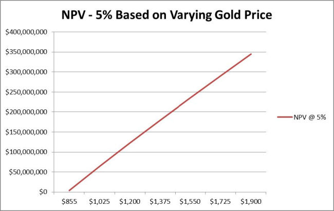
Figure 22-1 Gold Price Sensitivity
|
22.6.2
|
Operating Cost, Capital Cost and Gold Grade
|
The project is quite sensitive to the cost of operations, incurring an $18 million decline in the NPV-5 for each increase of 10% in the operating costs, yielding a $13 million decline in the NPV-5 for each increase of 10% in the capital costs, and experiencing a $40 million increase in the NPV-5 for each increase of 10% in the average ore grade fed to the processing plant, as shown in Figure 22-2.
| December 19, 2011 | 176 | |
| Midway Gold Corp. | Economic Analysis |
| Pan Gold Project Feasibility Study | NI 43-101 Technical Report |

| December 19, 2011 | 177 | |
| Midway Gold Corp. | Adjacent Properties |
| Pan Gold Project Feasibility Study | NI 43-101 Technical Report |
|
23
|
ADJACENT PROPERTIES
|
Adjacent properties have no known existing, potential, or reasonable future material impact on the Pan Project. MIDWAY’s Gold Rock Project is located 8 miles to the southeast of Pan, and could offer opportunities for synergistic development.
| December 19, 2011 | 178 | |
| Midway Gold Corp. | Other Relevant Data and Information |
| Pan Gold Project Feasibility Study | NI 43-101 Technical Report |
|
24
|
OTHER RELEVANT DATA AND INFORMATION
|
Gustavson knows of no additional information or explanation necessary to make this report more understandable. This Technical Report has been prepared to accurately and independently reflect the information contained in the Feasibility Study prepared by Gustavson Associates.
| December 19, 2011 | 179 | |
| Midway Gold Corp. | Interpretation and Conclusion |
| Pan Gold Project Feasibility Study | NI 43-101 Technical Report |
|
25
|
INTERPRETATION AND CONCLUSIONS
|
Based on the work done as part of and resulting from this Feasibility Study, Gustavson concludes:
|
●
|
The Pan deposit now contains over 1.1 million ounces of gold in Measured and Indicated Mineral Resource categories using a 0.004 opt cutoff.
|
|
●
|
There continues to be good potential for the discovery of additional Mineral Resources at Pan.
|
|
●
|
There is a proven and probable Mineral Reserve of 53,254,000 tons, containing 864,000 ounces of gold.
|
|
●
|
The Pan project is an economic mining project generating approximately $122 million net present value, and an internal rate of return of 32.4% at a gold price of $1200.
|
| December 19, 2011 | 180 | |
| Midway Gold Corp. | Recommendations |
| Pan Gold Project Feasibility Study | NI 43-101 Technical Report |
|
26
|
RECOMMENDATIONS
|
Based on the results of this Feasibility Study, Gustavson recommends:
|
●
|
Continuation of drilling to fill-in areas that are promising development areas, specifically between the North and South pits. MIDWAY is planning on $ 1.5 million in drilling for the next two years.
|
|
●
|
Finalization of engineering for infrastructure, buildings, mining, and site facilities. This is currently estimated at $0.86 million (included in capital costs in the Feasibility Study)
|
|
●
|
Support for the EIS and permitting, estimated to be $ 0.4 million over the next 2 years.
|
|
●
|
Construction of the access road which is estimated at $ 1.7 million.
|
|
●
|
Drilling and testing of a water well, estimated at $0.1 million.
|
|
●
|
Purchase of long-lead equipment estimated at approximately $ 2.0 million.
|
|
●
|
Additional Geotechnical testing for pit-slope designs, as discussed in the Mining Section of this Technical Report. The estimated cost for this work is approximately $0.2 million.
|
| December 19, 2011 | 181 | |
| Midway Gold Corp. | References |
| Pan Gold Project Feasibility Study | NI 43-101 Technical Report |
|
27
|
REFERENCES
|
|
|
Adair, D.H. and Stringham B.F., 1960, Intrusive Igneous Rocks of East Central Nevada, in Guidebook to the Geology of East-Central Nevada, Intermountain Association of Petroleum Geologists and Eastern Nevada Geological Society, 11th Annual Field Conference, Salt Lake City, Utah, 1960
|
|
|
AMEC, 2008, T. Wakefield and E.J.C. Orbock, E. Pan Mineral Resource Estimate and Data Review, File No. 158964. Prepared by AMEC for Midway Gold Corp., May 9th, 2008.
|
|
|
Armstrong, 1970, Geochronology of Tertiary Igneous Rocks, Eastern Basin and Range Province, Western Utah, Eastern Nevada, and Vicinity, Geochem. Et Cosmochim Acta, v34, no2.
|
|
|
Ashleman, J. and Bernardi, M., 2001, Pan Prospect, White Pine County, Nevada, Geologic Map, Unpublished Geologic Mapping of the Pan Project Area, Degerstrom and Latitude Minerals.
|
|
|
Bradbury, J.A., 2000, Column Leach Test work, Pan Core Samples, NA Degerstrom Inc., report to Latitude Minerals Corp.
|
|
|
Gathje, J.C., 1988, HRI Project 005-851, Cyanide Leach Tests of Three Pan Gold Ore Samples, Hazen Research Inc for Echo Bay Management Corp.
|
|
|
Golder Associates, Inc., 2010, Pan Project White Pine County, NV Draft Report on Scoping Level Pit Slope Evaluation for Midway Gold Corp Resources, Inc.
|
|
|
Golder Associates, Inc., 2011, Pan Project White Pine County, Nevada, Pre-Feasibility Level Pit Slope Evaluation for Midway Gold Corp Resources, Inc., April 2011.
|
|
|
Gustavson Associates, LLC, 2010, NI 43-101 Preliminary Economic Assessment of the Pan Gold Project, White Pine County, Nevada, July 20, 2010.
|
|
|
Gustavson Associates, LLC, 2011, NI 43-101 Preliminary Feasibility Study of the Pan Gold Project, White Pine County, Nevada, April 4, 2011.
|
|
|
Gustavson Associates, LLC, 2011, NI 43-101 Updated Mineral Resource Estimate for the Pan Gold Project, White Pine County, Nevada, September 1, 2011.
|
|
|
Harris, D., 2007, Pan Project Geology Map, Unpublished Geologic Map of the Pan Property, Midway Gold Corp Resources, Inc. (Midway Gold US Inc.).
|
| December 19, 2011 | 182 | |
| Midway Gold Corp. | References |
| Pan Gold Project Feasibility Study | NI 43-101 Technical Report |
|
|
Harris, D., 2009, Pan Project White Pine County, Nevada NI 43-101 Technical Report, Midway Gold Resources, Inc. for Midway Gold Corp (Midway Gold US Inc.)
|
|
|
Hose, R.K and Blake, M.C., 1976, Part II, Mineral Resources, in Geology and Mineral Resources of White Pine County, Nevada, Nevada Bureau of Mines and Geology, Bulletin 85.
|
|
|
Jeanne, R.A., 1988, Pan Project, Operations Conducted in 1987, Echo Bay Exploration Inc., report to Lyle F. Campbell Trust.
|
|
|
Jeanne, R.A., 1988, Report on Exploration, Pan Project, White Pine County, Nevada, Echo Bay Exploration, Inc., Internal Report.
|
|
|
KCA, 2004, T. Albert, Pan Metallurgical Program, Kappes, Cassidy, & Associates, for Castleworth Ventures.
|
|
|
McClelland, G.E., 1987, Report on Column Percolation Leach Tests on Pan Jasperoids, ML Job No. 1049, McClelland Laboratories, Inc, memorandum to Echo Bay Management Corp.
|
|
|
McClelland, G.E., 1987, Interim Report on Preliminary Cyanidation Test work on Pan Jasperoids, MLI Job No. 1049, McClelland Laboratories Inc. memorandum to Echo Bay Management Corp.
|
|
|
MDA, 2005, M. Gustin. Pan Gold Project, Updated Technical Report, White Pine County, Nevada USA, Prepared by Mine Development Associates Mine Engineering Services for Castleworth Ventures Inc. January 2005.
|
|
|
Muerhoff, C.V., 2003, Technical Report, Pan Gold Project, White Pine County, Nevada, USA, Mine Development Associates, Inc, Independent technical report prepared for Castleworth Ventures Inc.
|
|
|
Myers, I.A., 1990, Status of Pan Project, Alta Gold Co., internal memorandum.
|
|
|
Myers, I.A., 1990, Update of Metallurgical Study of the Pan Deposits, Alta Gold Co. internal memorandum.
|
|
|
Myers, I.A., 1990, Final Review of Metallurgical Study Conducted for the Pan Project, Alta Gold internal memorandum.
|
|
|
Myers, I.A., 1990, Metallurgical Study, Pan Project, Alta Gold Co internal memorandum.
|
| December 19, 2011 | 183 | |
| Midway Gold Corp. | References |
| Pan Gold Project Feasibility Study | NI 43-101 Technical Report |
|
|
Myers, I.A., 1990, Pan Mineral Lease, 1989 Activities Report, Alta Bay Joint Venture, Alta Bay Venture Report to LFC Trust.
|
|
|
Myers, I.A., 1991, Pan Project, 1990 Annual Report, Alta Bay Joint Venture, Alta Bay Venture Report to LFC Trust.
|
|
|
Resource Development Inc., 2011, Metallurgical Testing of Midway Pan Samples, September 28, 2011.
|
|
|
Sherrin, C.H., 1988, Report on Agitate Cyanidation Tests - Pan Cuttings Composites, MLI Job No. 1140, McClelland Laboratories for Echo Bay Exploration.
|
|
|
Shrake, T., 1984, Geology and Hydrothermal Alteration of the Pan Disseminated Gold Occurrence, White Pine County, Nevada, M.S. Thesis, University of Idaho.
|
|
|
Smith, R.M., 1976, Part II, Mineral Resources, in Geology and Mineral Resources of White Pine County, Nevada, Nevada Bureau of Mines and Geology, Bulletin 85.
|
|
|
SRK, 2009, Draft Report, Pan Gold Project, White Pine County, Nevada, prepared for Confidential Client by SRK Consulting.
|
|
|
Thompson, P., 1987, Results of Assay Screen and Cyanide Leach Testing 3 Each Composite Ore Samples, Project o. P-1349, Dawson Metallurgical Laboratories, Inc, memorandum to Echo Bay Mines.
|
|
|
White, R. and Buxton, C., 1999, Resource Estimation and Exploration Potential for the Pan Gold Deposit, White Pine County, Nevada, Lynn Canal Geological Services report to Latitude Minerals Corp.
|
|
|
Western Regional Climate Website, 2008, Desert Research Institute (www.wrcc.dri.edu)
|
|
|
Wright, J.L., 2008, Pan Property Gravity Survey Phase II, GIS Database, Report to Midway Gold Corp, 16p
|
| December 19, 2011 | 184 | |